
Akaroa Harbour: Difference between revisions
c/e; add link to Wikivoyage |
No edit summary |
||
| Line 19: | Line 19: | ||
}} |
}} |
||
'''Akaroa Harbour''' is part of [[Banks Peninsula]] in the [[Canterbury Region]] of [[New Zealand]]. It enters from the southern coast of the peninsula, heading in a predominantly northerly direction. The name Akaroa is [[Ngāi Tahu|Kāi Tahu]] [[Māori language|Māori]] for "Long Harbour".<ref name="Reed2002">{{cite book|last=Reed|first=Alexander Wyclif|title=The Reed Dictionary of New Zealand Place Names |url= http://books.google.com/books?id=N3OhAAAACAAJ |date=2002-01-23|publisher=Reed Books |isbn=9780790007618}}</ref> [[Ōnawe Peninsula]] is at the head of the harbour, the former site of a Māori [[pā]]. |
'''Akaroa Harbour''' is part of [[Banks Peninsula]] in the [[Canterbury Region]] of [[New Zealand]]. It enters from the southern coast of the peninsula, heading in a predominantly northerly direction. The name Akaroa is [[Ngāi Tahu|Kāi Tahu]] [[Māori language|Māori]] for "Long Harbour".<ref name="Reed2002">{{cite book|last=Reed|first=Alexander Wyclif|title=The Reed Dictionary of New Zealand Place Names |url= http://books.google.com/books?id=N3OhAAAACAAJ |date=2002-01-23|publisher=Reed Books |isbn=9780790007618}}</ref> [[Ōnawe Peninsula]] is at the head of the harbour, the former site of a Māori [[pā]]. The entire harbour is the [[caldera]] of an extinct [[volcano]].<ref>{{cite journal|title=The Basal Beds of the Akaroa Volcano|author=R. Speight|journal=Transactions and Proceedings of the Royal Society of New Zealand|volume=70|year=1940|page=6-}}</ref> |
||
The towns or settlements of [[Akaroa]], [[Duvauchelle]], Barrys Bay, French Farm and Wainui lie on the shoreline of the harbour. [[Cruise ship]]s occasionally enter the harbour, with the passengers visiting Akaroa.<ref>{{cite web|url=http://ccc.govt.nz/visiting/cruiseshipvisits.aspx |title=Cruise ship visits |date=2 November 2011|publisher=Christchurch City Council|accessdate=10 May 2012}}</ref> |
The towns or settlements of [[Akaroa]], [[Duvauchelle]], Barrys Bay, French Farm and Wainui lie on the shoreline of the harbour. [[Cruise ship]]s occasionally enter the harbour, with the passengers visiting Akaroa.<ref>{{cite web|url=http://ccc.govt.nz/visiting/cruiseshipvisits.aspx |title=Cruise ship visits |date=2 November 2011|publisher=Christchurch City Council|accessdate=10 May 2012}}</ref> |
||
Revision as of 07:46, 3 March 2015
.svg)
Akaroa Harbour is part of Banks Peninsula in the Canterbury Region of New Zealand. It enters from the southern coast of the peninsula, heading in a predominantly northerly direction. The name Akaroa is Kāi Tahu Māori for "Long Harbour".[1] Ōnawe Peninsula is at the head of the harbour, the former site of a Māori pā. The entire harbour is the caldera of an extinct volcano.[2]
The towns or settlements of Akaroa, Duvauchelle, Barrys Bay, French Farm and Wainui lie on the shoreline of the harbour. Cruise ships occasionally enter the harbour, with the passengers visiting Akaroa.[3]
The 475-hectare (1,170-acre) Akaroa Marine Reserve was given approval in 2013 after a 17 year campaign to get it established.
As of 2011[update], of the seven sites that are sampled in the harbour for water quality, six are graded as "good" and one as "fair" in terms of recreational use. Rainfall affects the grading.[4]
-
 Ships in Akaroa Harbour in the early 19th century. Some Maori whare are in the foreground.
 -
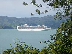 The Sapphire Princess in Akaroa Harbour. (Summer 2010)


See also
References
- ^ Reed, Alexander Wyclif (2002-01-23). The Reed Dictionary of New Zealand Place Names. Reed Books. ISBN 9780790007618.
- ^ R. Speight (1940). "The Basal Beds of the Akaroa Volcano". Transactions and Proceedings of the Royal Society of New Zealand. 70: 6-.
- ^ "Cruise ship visits". Christchurch City Council. 2 November 2011. Retrieved 10 May 2012.
- ^ "Recreational Water Quality Map 2011". Environment Canterbury. 2011. Retrieved 10 May 2012.
External links
- Akaroa and Akaroa Harbour at Te Ara: The Encyclopedia of New Zealand (published in the 1966 An Encyclopaedia of New Zealand)
- Akaroa Harbour Issues Working Party at Environment Canterbury
- Save Akaroa Harbour (Akaroa Harbour Marine Protection Society)