
Long Run (Elk Run tributary): Difference between revisions
m Robot - Moving category Rivers of Sullivan County, Pennsylvania to Category:Rivers and streams of Sullivan County, Pennsylvania per CFD at Wikipedia:Categories for discussion/Log/2015 December 9. |
Cyberbot II (talk | contribs) Rescuing 1 sources. #IABot |
||
| Line 25: | Line 25: | ||
The elevation near the [[river mouth|mouth]] of Long Run is {{convert|1217|ft|m}} above [[sea level]].<ref name = "gnis">{{Citation|author = [[Geographic Names Information System]]|url = http://gnis.usgs.gov/apex/f?p=136:3:0::NO:3:P3_FID,P3_TITLE:1179887,Long%20Run|title = Feature Detail Report for: Long Run|accessdate = January 9, 2015}}</ref> The elevation of the stream's [[river source|source]] is between {{convert|2360|and|2380|ft|m}} above sea level.<ref name = "nationalmap"/> |
The elevation near the [[river mouth|mouth]] of Long Run is {{convert|1217|ft|m}} above [[sea level]].<ref name = "gnis">{{Citation|author = [[Geographic Names Information System]]|url = http://gnis.usgs.gov/apex/f?p=136:3:0::NO:3:P3_FID,P3_TITLE:1179887,Long%20Run|title = Feature Detail Report for: Long Run|accessdate = January 9, 2015}}</ref> The elevation of the stream's [[river source|source]] is between {{convert|2360|and|2380|ft|m}} above sea level.<ref name = "nationalmap"/> |
||
Most of the valley of Long Run is on a glacial or resedimented [[till]] known as the Wisconsinan Bouldery Till. This till contains numerous [[boulder]]s consisting of [[sandstone]], [[quartz]], and [[conglomerate (geology)|conglomerate]]. The rest of the stream's valley, as well as the slopes of the valley, are on [[bedrock]] consisting of [[shale]] and sandstone. A till known as the Wisconsinan Till occurs near the headwaters of the stream.<ref>{{Citation|author |
Most of the valley of Long Run is on a glacial or resedimented [[till]] known as the Wisconsinan Bouldery Till. This till contains numerous [[boulder]]s consisting of [[sandstone]], [[quartz]], and [[conglomerate (geology)|conglomerate]]. The rest of the stream's valley, as well as the slopes of the valley, are on [[bedrock]] consisting of [[shale]] and sandstone. A till known as the Wisconsinan Till occurs near the headwaters of the stream.<ref>{{Citation|author=Duane D. Braun |url=http://www.dcnr.state.pa.us/topogeo/openfile/elkgrove.pdf |title=SURFICIAL GEOLOGY OF THE ELK GROVE 7.5-MINUTE QUADRANGLE SULLIVAN, COLUMBIA, AND LYCOMING COUNTIES, PENNSYLVANIA |page=20 |year=2007 |accessdate=January 10, 2015 |deadurl=unfit |archiveurl=https://web.archive.org/web/20070712171601/http://www.dcnr.state.pa.us/topogeo/openfile/elkgrove.pdf |archivedate=July 12, 2007 }}</ref> |
||
==Watershed== |
==Watershed== |
||
Revision as of 21:32, 2 April 2016
| Long Run | |
|---|---|
| Physical characteristics | |
| Mouth | Elk Run in Davidson Township, Sullivan County, Pennsylvania |
• coordinates | 41°18′37″N 76°24′37″W / 41.31026°N 76.41018°W |
| Basin features | |
| Progression | Elk Run → West Branch Fishing Creek → Fishing Creek → Susquehanna River → Chesapeake Bay |
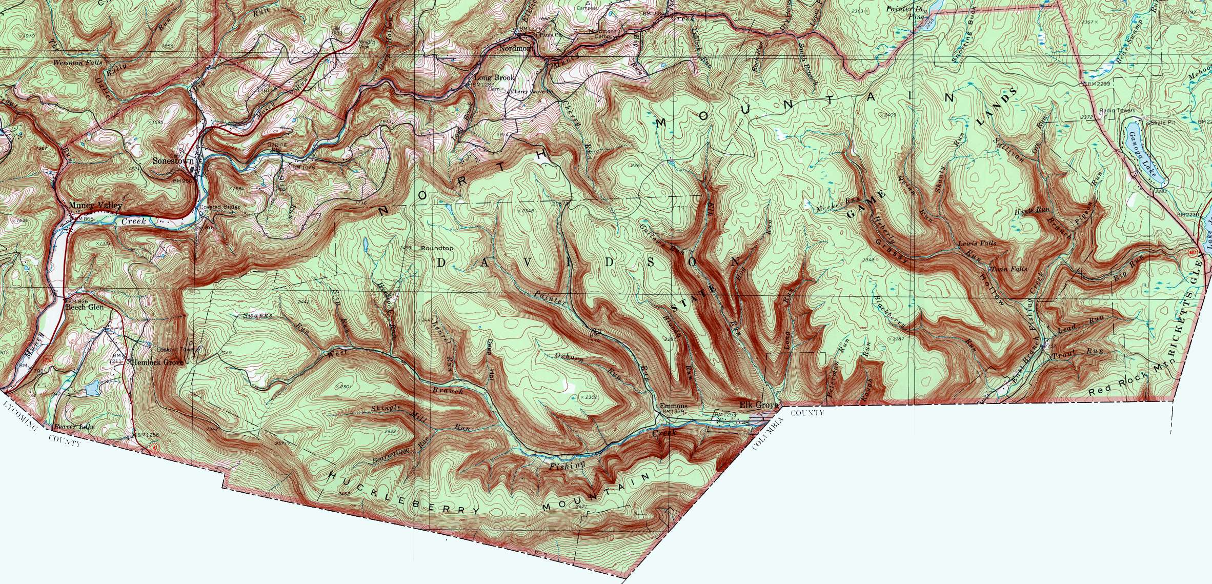
Long Run is a tributary of Elk Run in Sullivan County, Pennsylvania, in the United States. It is approximately 2.4 miles (3.9 km) long and flows through Davidson Township.[1] The stream's watershed has an area of 1.92 square miles (5.0 km2). It has no named tributaries, but four unnamed tributaries. The stream is considered by the Pennsylvania Department of Environmental Protection to be impaired by atmospheric deposition and metals. Wisconsinan Bouldery Till, Wisconsinan Till, and bedrock consisting of sandstone and shale occur in the vicinity of it.
Course
Long Run begins at the top of a deep valley in Davidson Township. It flows south for several tenths of a mile, receiving two unnamed tributaries from the left. The stream then turns south-southwest and its valley becomes considerably deeper. It then turns south for more than a mile, receiving two more unnamed tributaries from the left. The stream then turns southwest, exits its valley, and reaches its confluence with Elk Run near the border between Sullivan County and Columbia County.[1]
Long Run joins Elk Run 0.42 miles (0.68 km) upstream of its mouth.[2]
Hydrology
Long Run is considered to be impaired by atmospheric deposition and metals. A total of 4.25 miles (6.84 km) of the stream and its unnamed tributaries have this impairment. This is approximately 10.5 percent of all the impaired streams in the watersheds of West Branch Fishing Creek and East Branch Fishing Creek.[3]
Long Run does not attain the stream standards of the Pennsylvania Department of Environmental Protection. None of its four unnamed tributaries attain the standards either.[4]
Geography and geology
The elevation near the mouth of Long Run is 1,217 feet (371 m) above sea level.[5] The elevation of the stream's source is between 2,360 and 2,380 feet (720 and 730 m) above sea level.[1]
Most of the valley of Long Run is on a glacial or resedimented till known as the Wisconsinan Bouldery Till. This till contains numerous boulders consisting of sandstone, quartz, and conglomerate. The rest of the stream's valley, as well as the slopes of the valley, are on bedrock consisting of shale and sandstone. A till known as the Wisconsinan Till occurs near the headwaters of the stream.[6]
Watershed
The watershed of Long Run has an area of 1.92 square miles (5.0 km2).[2] The stream is entirely within the United States Geological Survey quadrangle of Elk Grove.[5]
Long Run is one of twenty streams in the Upper Susquehanna-Lackawanna drainage basin whose streambed is publicly owned.[7] The streambeds of the two other named tributaries of Elk Run (Hog Run and Gallows Run) are also publicly owned, as is the streambed of Elk Run itself.[7][8]
History
Long Run was entered into the Geographic Names Information System on August 2, 1979. Its identifier in the Geographic Names Information System is 1179887.[5]
See also
- Hog Run, next tributary of Elk Run going upstream
- List of tributaries of Fishing Creek (North Branch Susquehanna River)
References
- ^ a b c United States Geological Survey, The National Map Viewer, retrieved January 9, 2015
- ^ a b Pennsylvania Gazetteer of Streams (PDF), November 2, 2001, p. 92, retrieved January 9, 2015
- ^ Rod Morehart (2006), Sullivan County's Implementation Plan For the Chesapeake Bay Tributary Strategy (PDF), p. 5, retrieved January 9, 2015
- ^ Attaining/Non-Attaining Streams (PDF), June 26, 2012, retrieved January 9, 2015
- ^ a b c Geographic Names Information System, Feature Detail Report for: Long Run, retrieved January 9, 2015
- ^ Duane D. Braun (2007), SURFICIAL GEOLOGY OF THE ELK GROVE 7.5-MINUTE QUADRANGLE SULLIVAN, COLUMBIA, AND LYCOMING COUNTIES, PENNSYLVANIA (PDF), p. 20, archived from the original (PDF) on July 12, 2007, retrieved January 10, 2015
{{citation}}: Unknown parameter|deadurl=ignored (|url-status=suggested) (help) - ^ a b Pennsylvania Department of Conservation and Natural Resources, Publicly-Owned Streambeds (See Note on Page 6) by Hydrologic Unit Code 8 (HUC8) Watershed (PDF), pp. 5, 6, retrieved January 9, 2015
- ^ United States Geological Survey (1991), davidson.jpg, retrieved January 9, 2015