BR-060 (Brazil highway): Difference between revisions
Appearance
Content deleted Content added
Added an infobox for WikiProject Brazil. |
Rescuing 1 sources and tagging 0 as dead. #IABot (v1.2.5) |
||
| Line 24: | Line 24: | ||
}} |
}} |
||
'''BR-060''' is a federal highway of [[Brazil]].<ref>{{cite web|url=http://www2.transportes.gov.br/bit/02-rodo/3-loc-rodo/loc-rodo/br-060/gbr-060.htm|title=BR-60|publisher=[[Ministry of Transport (Brazil)|Ministry of Transport]]|accessdate=7 June 2011 |
'''BR-060''' is a federal highway of [[Brazil]].<ref>{{cite web |
||
|url=http://www2.transportes.gov.br/bit/02-rodo/3-loc-rodo/loc-rodo/br-060/gbr-060.htm |
|||
|title=BR-60 |
|||
|publisher=[[Ministry of Transport (Brazil)|Ministry of Transport]] |
|||
|accessdate=7 June 2011 |
|||
|deadurl=yes |
|||
|archiveurl=https://web.archive.org/web/20121122064914/http://www2.transportes.gov.br/bit/02-rodo/3-loc-rodo/loc-rodo/br-060/gbr-060.htm |
|||
|archivedate=22 November 2012 |
|||
|df= |
|||
}} |
|||
</ref> The 1459 kilometre road connects [[Brasilia]] to [[Bela Vista]], on the [[Paraguay]]an border.<ref>[http://www2.transportes.gov.br/bit/02-rodo/3-loc-rodo/loc-rodo/060.htm BR 060 map]</ref> |
</ref> The 1459 kilometre road connects [[Brasilia]] to [[Bela Vista]], on the [[Paraguay]]an border.<ref>[http://www2.transportes.gov.br/bit/02-rodo/3-loc-rodo/loc-rodo/060.htm BR 060 map]</ref> |
||
Revision as of 12:15, 23 October 2016
| BR-060 | |
|---|---|
 | |
 | |
| Location | |
| Country | Brazil |
| Highway system | |
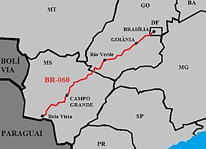
BR-060 is a federal highway of Brazil.[1] The 1459 kilometre road connects Brasilia to Bela Vista, on the Paraguayan border.[2]
It is also designated as part of the Belém-Brasília Highway, in its stretch between Brasília and Anápolis.
References
- ^ "BR-60". Ministry of Transport. Archived from the original on 22 November 2012. Retrieved 7 June 2011.
{{cite web}}: Unknown parameter|deadurl=ignored (|url-status=suggested) (help) - ^ BR 060 map

