
Blackfoot Glacier: Difference between revisions
Entranced98 (talk | contribs) m Reverted edits by 199.43.174.53 (talk) to last version by 141.218.35.175 |
Rescuing 2 sources and tagging 0 as dead. #IABot (v1.2.6) |
||
| Line 14: | Line 14: | ||
| long_d=113 | long_m=40 | long_s=12 |long_EW=W |
| long_d=113 | long_m=40 | long_s=12 |long_EW=W |
||
| coordinates_ref =<ref name=gnis>{{cite gnis|id=768994|name=Blackfoot Glacier|accessdate=2013-02-09}}</ref> |
| coordinates_ref =<ref name=gnis>{{cite gnis|id=768994|name=Blackfoot Glacier|accessdate=2013-02-09}}</ref> |
||
| area = {{convert|441|acre|km2}} in 2005<ref name=NOROCK>{{Cite web|title=Retreat of Glaciers in Glacier National Park|publisher=United States Geological Survey|year=2010|url=http://www.nrmsc.usgs.gov/files/norock/products/GlacierRecession_infosheet2010_SRC_040910.pdf|format=pdf|accessdate=2013-02-09}}</ref> |
| area = {{convert|441|acre|km2}} in 2005<ref name=NOROCK>{{Cite web|title=Retreat of Glaciers in Glacier National Park |publisher=United States Geological Survey |year=2010 |url=http://www.nrmsc.usgs.gov/files/norock/products/GlacierRecession_infosheet2010_SRC_040910.pdf |format=pdf |accessdate=2013-02-09 |deadurl=yes |archiveurl=https://web.archive.org/web/20120511154502/http://www.nrmsc.usgs.gov/files/norock/products/GlacierRecession_infosheet2010_SRC_040910.pdf |archivedate=May 11, 2012 |df=mdy }}</ref> |
||
| length = {{convert|1|mi|km}} |
| length = {{convert|1|mi|km}} |
||
| thickness = |
| thickness = |
||
| Line 22: | Line 22: | ||
'''Blackfoot Glacier''' is the second largest of the remaining 25 glaciers in [[Glacier National Park (U.S.)|Glacier National Park]], [[Montana]]. Blackfoot Glacier is just to the north of [[Blackfoot Mountain]] and near [[Jackson Glacier]].<ref name=NOROCK/><ref name=topo>{{Cite map|publisher=TopoQwest (United States Geological Survey Maps)|title=Mount Jackson, MT|url=http://www.topoquest.com/map.php?lat=48.59024&lon=-113.66512&datum=nad83&zoom=4|accessdate=2013-02-09}}</ref> The glacier was most recently measured in 2005 at {{convert|441|acre|km2}}, yet when first documented in 1850, the glacier also included the now separate Jackson Glacier and together, they covered {{convert|1875|acre|km2}}. In 1850, there were an estimated 150 glaciers in the park. Glaciologists have stated that by the year 2030, all the glaciers in the park may disappear.<ref name=hall>{{cite journal|last=Hall|first=Myrna H.P.|author2=Daniel B. Fagre|title=Modeled Climate-Induced Glacier Change in Glacier National Park, 1850–2100|journal=BioScience|date=February 2003|volume=53|issue=2|pages=131–140|url=http://www.nrmsc.usgs.gov/files/norock/products/GCC/Bioscience_Hall_03.pdf|accessdate=2013-02-09|format=PDF|doi=10.1641/0006-3568(2003)053[0131:mcigci]2.0.co;2}}</ref> However, under a modest increase in overall [[carbon dioxide]] levels, some glaciers will remain until the late 23rd century.<ref name=hall/> |
'''Blackfoot Glacier''' is the second largest of the remaining 25 glaciers in [[Glacier National Park (U.S.)|Glacier National Park]], [[Montana]]. Blackfoot Glacier is just to the north of [[Blackfoot Mountain]] and near [[Jackson Glacier]].<ref name=NOROCK/><ref name=topo>{{Cite map|publisher=TopoQwest (United States Geological Survey Maps)|title=Mount Jackson, MT|url=http://www.topoquest.com/map.php?lat=48.59024&lon=-113.66512&datum=nad83&zoom=4|accessdate=2013-02-09}}</ref> The glacier was most recently measured in 2005 at {{convert|441|acre|km2}}, yet when first documented in 1850, the glacier also included the now separate Jackson Glacier and together, they covered {{convert|1875|acre|km2}}. In 1850, there were an estimated 150 glaciers in the park. Glaciologists have stated that by the year 2030, all the glaciers in the park may disappear.<ref name=hall>{{cite journal|last=Hall|first=Myrna H.P.|author2=Daniel B. Fagre|title=Modeled Climate-Induced Glacier Change in Glacier National Park, 1850–2100|journal=BioScience|date=February 2003|volume=53|issue=2|pages=131–140|url=http://www.nrmsc.usgs.gov/files/norock/products/GCC/Bioscience_Hall_03.pdf|accessdate=2013-02-09|format=PDF|doi=10.1641/0006-3568(2003)053[0131:mcigci]2.0.co;2}}</ref> However, under a modest increase in overall [[carbon dioxide]] levels, some glaciers will remain until the late 23rd century.<ref name=hall/> |
||
Jackson and Blackfoot glaciers have been selected for monitoring by the [[U.S. Geological Survey]]'s Glacier Monitoring Research program, which is researching changes to the [[Glacier mass balance|mass balance]] of glaciers in and surrounding Glacier National Park. The glacier is being monitored using remote sensing equipment and [[repeat photography]], where images of the glacier are taken from identical locations periodically.<ref name=effects>{{cite web|title=Monitoring and Assessing Glacier Changes and Their Associated Hydrologic and Ecologic Effects in Glacier National Park|url=http://www.nrmsc.usgs.gov/research/glaciers.htm|work=Glacier Monitoring Studies|publisher=U.S. Geological Survey|accessdate=2013-02-09|year=2012}}</ref> Between 1966 and 2005, Blackfoot Glacier lost over 23 percent of its surface area.<ref name=NOROCK/> In the summer of 2007, a portion of Blackfoot Glacier broke off and formed an ice avalanche.<ref>{{cite web|last=Fagre|first=Dan|title=Losing a Legacy: A photographic story of disappearing glaciers|url=http://www.nrmsc.usgs.gov/files/norock/repeatphoto/Gallery_guide_general.pdf|publisher=U.S. Geological Survey|accessdate=2013-02-09|author2=Lisa McKeon}}</ref> |
Jackson and Blackfoot glaciers have been selected for monitoring by the [[U.S. Geological Survey]]'s Glacier Monitoring Research program, which is researching changes to the [[Glacier mass balance|mass balance]] of glaciers in and surrounding Glacier National Park. The glacier is being monitored using remote sensing equipment and [[repeat photography]], where images of the glacier are taken from identical locations periodically.<ref name=effects>{{cite web|title=Monitoring and Assessing Glacier Changes and Their Associated Hydrologic and Ecologic Effects in Glacier National Park |url=http://www.nrmsc.usgs.gov/research/glaciers.htm |work=Glacier Monitoring Studies |publisher=U.S. Geological Survey |accessdate=2013-02-09 |year=2012 |deadurl=yes |archiveurl=https://web.archive.org/web/20130218164617/http://www.nrmsc.usgs.gov/research/glaciers.htm |archivedate=February 18, 2013 |df=mdy }}</ref> Between 1966 and 2005, Blackfoot Glacier lost over 23 percent of its surface area.<ref name=NOROCK/> In the summer of 2007, a portion of Blackfoot Glacier broke off and formed an ice avalanche.<ref>{{cite web|last=Fagre|first=Dan|title=Losing a Legacy: A photographic story of disappearing glaciers|url=http://www.nrmsc.usgs.gov/files/norock/repeatphoto/Gallery_guide_general.pdf|publisher=U.S. Geological Survey|accessdate=2013-02-09|author2=Lisa McKeon}}</ref> |
||
{{gallery |
{{gallery |
||
Revision as of 20:50, 3 November 2016
| Blackfoot Glacier | |
|---|---|
 Blackfoot Glacier at left was once joined to Jackson Glacier on the right | |
 Blackfoot Glacier Location in Montana | |
| Type | Mountain glacier |
| Location | Glacier National Park, Glacier County, Montana, U.S. |
| Area | 441 acres (1.78 km2) in 2005[1] |
| Length | 1 mile (1.6 km) |
| Terminus | Moraine |
| Status | Retreating |
Blackfoot Glacier is the second largest of the remaining 25 glaciers in Glacier National Park, Montana. Blackfoot Glacier is just to the north of Blackfoot Mountain and near Jackson Glacier.[1][3] The glacier was most recently measured in 2005 at 441 acres (1.78 km2), yet when first documented in 1850, the glacier also included the now separate Jackson Glacier and together, they covered 1,875 acres (7.59 km2). In 1850, there were an estimated 150 glaciers in the park. Glaciologists have stated that by the year 2030, all the glaciers in the park may disappear.[4] However, under a modest increase in overall carbon dioxide levels, some glaciers will remain until the late 23rd century.[4]
Jackson and Blackfoot glaciers have been selected for monitoring by the U.S. Geological Survey's Glacier Monitoring Research program, which is researching changes to the mass balance of glaciers in and surrounding Glacier National Park. The glacier is being monitored using remote sensing equipment and repeat photography, where images of the glacier are taken from identical locations periodically.[5] Between 1966 and 2005, Blackfoot Glacier lost over 23 percent of its surface area.[1] In the summer of 2007, a portion of Blackfoot Glacier broke off and formed an ice avalanche.[6]
-
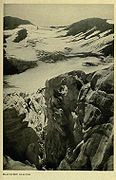 Blackfoot Glacier, 1917
 -
 The upper image shows how Blackfoot (on the left) and Jackson Glaciers (on the right) appeared in 1914. The lower image is taken from the same vantage point in 2001


See also
References
- ^ a b c "Retreat of Glaciers in Glacier National Park" (PDF). United States Geological Survey. 2010. Archived from the original (pdf) on May 11, 2012. Retrieved 2013-02-09.
{{cite web}}: Unknown parameter|deadurl=ignored (|url-status=suggested) (help) - ^ "Blackfoot Glacier". Geographic Names Information System. United States Geological Survey, United States Department of the Interior. Retrieved February 9, 2013.
- ^ Mount Jackson, MT (Map). TopoQwest (United States Geological Survey Maps). Retrieved February 9, 2013.
- ^ a b Hall, Myrna H.P.; Daniel B. Fagre (February 2003). "Modeled Climate-Induced Glacier Change in Glacier National Park, 1850–2100" (PDF). BioScience. 53 (2): 131–140. doi:10.1641/0006-3568(2003)053[0131:mcigci]2.0.co;2. Retrieved February 9, 2013.
- ^ "Monitoring and Assessing Glacier Changes and Their Associated Hydrologic and Ecologic Effects in Glacier National Park". Glacier Monitoring Studies. U.S. Geological Survey. 2012. Archived from the original on February 18, 2013. Retrieved 2013-02-09.
{{cite web}}: Unknown parameter|deadurl=ignored (|url-status=suggested) (help) - ^ Fagre, Dan; Lisa McKeon. "Losing a Legacy: A photographic story of disappearing glaciers" (PDF). U.S. Geological Survey. Retrieved February 9, 2013.