
Chic-Choc Mountains: Difference between revisions
m →External links: copyedit, already indirectly in category, refine cat, and AWB general fixes using AWB |
Rescuing 1 sources and tagging 0 as dead. #IABot (v1.2.7.1) |
||
| Line 53: | Line 53: | ||
==External links== |
==External links== |
||
* [http://www.peakbagger.com/range.aspx?rid=16010 Peakbagger.com page] |
* [http://www.peakbagger.com/range.aspx?rid=16010 Peakbagger.com page] |
||
* [http://www.markbrennanfineart.ca/gaspe.htm Mark A. Brennan Landscape Paintings of the Chic-Choc Mountains] |
* [https://web.archive.org/web/20070817022844/http://www.markbrennanfineart.ca:80/gaspe.htm Mark A. Brennan Landscape Paintings of the Chic-Choc Mountains] |
||
[[Category:Gaspé Peninsula]] |
[[Category:Gaspé Peninsula]] |
||
Revision as of 19:12, 21 November 2016
| Chic-Choc Mountains | |
|---|---|
 | |
| Highest point | |
| Peak | Mont Jacques-Cartier |
| Elevation | 1,268 m (4,160 ft) |
| Dimensions | |
| Length | 95 km (59 mi) East-West |
| Width | 10 km (6.2 mi) |
| Geography | |
Lua error in Module:Location_map at line 526: Unable to find the specified location map definition: "Module:Location map/data/Quebec (conic)" does not exist.
| |
| Country | Canada |
| Region | Quebec |
| Parent range | Notre Dame Mountains |
The Chic-Choc Mountains, also spelled Shick Shocks, is a mountain range in the central region of the Gaspé Peninsula in Quebec, Canada. It is a part of the Notre Dame Mountains, which is a continuation of the Appalachian Mountains.[1]
History
This section needs expansion. You can help by adding to it. (February 2013) |
The name Chic-Chocs comes from the Mi'kmaq word sigsôg, meaning "crags" or "rocky mountains."[disputed – discuss] It has undergone many different spellings over time, including Chikchâks (1836), Shick-shock (1857), and Chick-Saws (1863).[1]
Geography
The Chic-Chocs run parallel to the St. Lawrence River and are located some 20 to 40 kilometers inland. They are a narrow band of mountains approximately 95 kilometres (59 mi) long and 10 kilometres (6.2 mi) wide.[1] The Chic-Chocs are heavily eroded, with rounded, flattened tops and steep sides. Over 25 mountains in the range have peaks higher than 1,000 metres (3,300 ft); the highest is Mont Jacques-Cartier at 1,268 metres (4,160 ft). Caribou can be found in the plateaus of this region.
Tourism
Although visited by just a few tourists, Chic-Choc Mountains became much more popular in the late 1990s as backcountry skiing gained popularity in Eastern Canada.
A network of trails, including the International Appalachian Trail, passes through these mountains. Quebec's Parc national de la Gaspésie protects most of the mountain range.
-
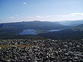
 View from Mont Jacques-Cartier.
 -
 Winter in the Chic Choc Mountains
 -
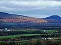 Near Sayabec
 -
 Parc de la Gaspésie


References
- ^ a b c "Monts Chic-Chocs". Banque de noms de lieux du Québec (in French). Commission de Toponymie. Retrieved 1 Feb 2011.
External links
This Quebec location article is a stub. You can help Wikipedia by expanding it. |