
Datil Mountains: Difference between revisions
Zackmann08 (talk | contribs) Fixing infobox not to use deprecated coordinates format |
Rescuing 1 sources and tagging 0 as dead. #IABot (v1.2.7.1) |
||
| Line 23: | Line 23: | ||
The Datils contain [[scrubland]], [[pinyon-juniper woodland]], [[ponderosa pine]] forest, deciduous [[oak]] and [[grassland]] areas. At lower elevations, grasses include [[Black grama|black]] and [[sideoats grama]], [[poverty three-awn]], [[burrograss]], and [[galleta grass]]. Higher up, grass species include [[Blue grama|blue]] and [[hairy grama]], and [[little bluestem]]. Shrubs include [[Dasylirion wheeleri|sotol]], [[Cylindropuntia|cholla]], [[yucca]], [[Apache plume]], [[mountain mahogany]], [[shrub live oak]], [[gambel oak]], and [[Juniperus deppeana|alligator juniper]]. Wildlife includes [[elk]], [[mule deer]], [[Merriam's turkey]], [[American black bear|black bears]], [[bobcat]]s, [[coyote]]s, [[fox]]es, [[Bald eagle|bald]] and [[golden eagle]]s, [[prairie falcon]], [[kestrel]], [[hawk]]s, and [[owl]]s as well as [[Gambel's quail|Gambel's]], [[Scaled quail|scaled]], and [[Mearn's quail]]. |
The Datils contain [[scrubland]], [[pinyon-juniper woodland]], [[ponderosa pine]] forest, deciduous [[oak]] and [[grassland]] areas. At lower elevations, grasses include [[Black grama|black]] and [[sideoats grama]], [[poverty three-awn]], [[burrograss]], and [[galleta grass]]. Higher up, grass species include [[Blue grama|blue]] and [[hairy grama]], and [[little bluestem]]. Shrubs include [[Dasylirion wheeleri|sotol]], [[Cylindropuntia|cholla]], [[yucca]], [[Apache plume]], [[mountain mahogany]], [[shrub live oak]], [[gambel oak]], and [[Juniperus deppeana|alligator juniper]]. Wildlife includes [[elk]], [[mule deer]], [[Merriam's turkey]], [[American black bear|black bears]], [[bobcat]]s, [[coyote]]s, [[fox]]es, [[Bald eagle|bald]] and [[golden eagle]]s, [[prairie falcon]], [[kestrel]], [[hawk]]s, and [[owl]]s as well as [[Gambel's quail|Gambel's]], [[Scaled quail|scaled]], and [[Mearn's quail]]. |
||
The range contains important breeding ground for [[mountain lion]] and the southern portion is important for mountain lion connectivity.<ref name="Menke 2008">{{cite web|last=Menke|first=K.|title=Locating Potential Cougar (Puma concolor) Corridors in New Mexico Using a Least-Cost Path Corridor GIS Analysis|url=http://www.wildlife.state.nm.us/conservation/share_with_wildlife/documents/SwW08Menke.pdf}}</ref> [[The Nature Conservancy]] identified the Datils as a key conservation area in New Mexico due to the range’s ecological diversity and species richness.<ref name="TNC 2004">{{cite book|last=The Nature Conservancy|title=Chapter 10: Ecological & Biological Diversity of the Cibola National Forest, Mountain Districts in Ecological and Biological Diversity of National Forests in Region 3|year=2004|url=Available online at http://www.fs.usda.gov/detail/r3/landmanagement/planning/?cid=fsbdev3_022067}}</ref> |
The range contains important breeding ground for [[mountain lion]] and the southern portion is important for mountain lion connectivity.<ref name="Menke 2008">{{cite web|last=Menke |first=K. |title=Locating Potential Cougar (Puma concolor) Corridors in New Mexico Using a Least-Cost Path Corridor GIS Analysis |url=http://www.wildlife.state.nm.us/conservation/share_with_wildlife/documents/SwW08Menke.pdf |deadurl=yes |archiveurl=https://web.archive.org/web/20130515154114/http://www.wildlife.state.nm.us/conservation/share_with_wildlife/documents/SwW08Menke.pdf |archivedate=2013-05-15 |df= }}</ref> [[The Nature Conservancy]] identified the Datils as a key conservation area in New Mexico due to the range’s ecological diversity and species richness.<ref name="TNC 2004">{{cite book|last=The Nature Conservancy|title=Chapter 10: Ecological & Biological Diversity of the Cibola National Forest, Mountain Districts in Ecological and Biological Diversity of National Forests in Region 3|year=2004|url=Available online at http://www.fs.usda.gov/detail/r3/landmanagement/planning/?cid=fsbdev3_022067}}</ref> |
||
{{Gallery |
{{Gallery |
||
Revision as of 08:46, 7 December 2016
| Datil Mountains | |
|---|---|
 Looking south at the Madre Mountain Inventoried Roadless Area in the Datil Mountains. | |
 | |
| Location | New Mexico, United States |
| Nearest city | Datil, NM |
| Coordinates | 34°17′28″N 107°50′24″W / 34.291°N 107.840°W[1] |
| Governing body | U.S. Forest Service, Cibola National Forest |
| www | |

The Datil Mountains are a small range on the northern edge of the Mogollon-Datil volcanic field, just northwest of the Plains of San Agustin in the U.S. state of New Mexico. The range lies in Socorro and Catron Counties, north of the town of Datil, New Mexico and takes its name from the Spanish word for “date,” dating back over two hundred years. In The Place Names of New Mexico, Robert Julyan suggests two possible explanations for the name: 1) that “the seedpods of the broad-leafed yucca sufficiently resembled dates” or 2) “the Spanish applied the name to the fruit of the prickly pear cactus.”[2] The area includes the major ridgeline of Madre Mountain (elev. 9,556 feet), which is sacred ground to the Acoma, Laguna, and Zuni tribes, as well as several other unnamed peaks and ridges.[3]
The majority of the Datil Mountains are part of the Magdalena Ranger District of the Cibola National Forest. There are two Inventoried Roadless Areas (IRAs) within the Datil Mountains: the Datil (13,974 acres) and Madre Mountain (19,855 acres) IRAs. The landscape is expansive and natural with steep-sided hills cloaked with dense conifer forest. The jagged Sawtooth Mountains can be seen to the west.
Ecology
The Datils contain scrubland, pinyon-juniper woodland, ponderosa pine forest, deciduous oak and grassland areas. At lower elevations, grasses include black and sideoats grama, poverty three-awn, burrograss, and galleta grass. Higher up, grass species include blue and hairy grama, and little bluestem. Shrubs include sotol, cholla, yucca, Apache plume, mountain mahogany, shrub live oak, gambel oak, and alligator juniper. Wildlife includes elk, mule deer, Merriam's turkey, black bears, bobcats, coyotes, foxes, bald and golden eagles, prairie falcon, kestrel, hawks, and owls as well as Gambel's, scaled, and Mearn's quail.
The range contains important breeding ground for mountain lion and the southern portion is important for mountain lion connectivity.[4] The Nature Conservancy identified the Datils as a key conservation area in New Mexico due to the range’s ecological diversity and species richness.[5]
-
 A mule deer fawn in the snow. Photo: US Forest Service.
 -
 A mountain lion in the Cibola National Forest. Photo: US Forest Service.
 -
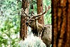 The Datil Mountains are home to elk. Photo: US Forest Service.
 -
 Bobcats live in the Datil Mountains. Photo: US Fish and Wildlife Service.
 -
 A black bear in Cibola National Forest. Photo: US Forest Service.


Recreation
The Datil Mountains provide outstanding opportunities for hiking, camping, backpacking, hunting, rock climbing, horseback riding and other forms of primitive dispersed recreation given the natural and rugged character, high quality habitat, remarkable views, and size. Thompson Canyon features the challenging Enchanted Tower, and is a popular destination for rock climbers.
References
- ^ "Datil Mountain Range". Mountain Zone.
- ^ Julyan, Robert (1996). The Place Names of New Mexico. University of New Mexico Press.
- ^ Basham, M. (2011). Magdalena Ranger District Background Survey. US Forest Service.
- ^ Menke, K. "Locating Potential Cougar (Puma concolor) Corridors in New Mexico Using a Least-Cost Path Corridor GIS Analysis" (PDF). Archived from the original (PDF) on 2013-05-15.
{{cite web}}: Unknown parameter|deadurl=ignored (|url-status=suggested) (help) - ^ The Nature Conservancy (2004). [Available online at http://www.fs.usda.gov/detail/r3/landmanagement/planning/?cid=fsbdev3_022067 Chapter 10: Ecological & Biological Diversity of the Cibola National Forest, Mountain Districts in Ecological and Biological Diversity of National Forests in Region 3].
{{cite book}}: Check|url=value (help)