
Groede: Difference between revisions
Content deleted Content added
JJMC89 bot (talk | contribs) Migrate {{Infobox settlement}} coordinates parameters to {{Coord}}, see Wikipedia:Coordinates in infoboxes |
Rescuing 1 sources and tagging 0 as dead. #IABot (v1.3beta3) |
||
| Line 22: | Line 22: | ||
'''Groede''' ({{IPA-nl|ˈɣrudə}}) is a village in the [[Netherlands|Dutch]] province of [[Zeeland]]. It is located about 5 km north of [[Oostburg]] in the municipality of [[Sluis]]. |
'''Groede''' ({{IPA-nl|ˈɣrudə}}) is a village in the [[Netherlands|Dutch]] province of [[Zeeland]]. It is located about 5 km north of [[Oostburg]] in the municipality of [[Sluis]]. |
||
Groede was a separate municipality until 1970.<ref>Ad van der Meer and Onno Boonstra, "Repertorium van Nederlandse gemeenten", KNAW, 2006. |
Groede was a separate municipality until 1970.<ref>Ad van der Meer and Onno Boonstra, "Repertorium van Nederlandse gemeenten", KNAW, 2006. {{cite web|url=http://www.knaw.nl/cfdata/publicaties/detail.cfm?boeken__ordernr%3D20061061 |title=Archived copy |accessdate=2009-12-03 |deadurl=yes |archiveurl=https://web.archive.org/web/20070220041404/http://www.knaw.nl/cfdata/publicaties/detail.cfm?boeken__ordernr=20061061 |archivedate=2007-02-20 |df= }}</ref> |
||
== Gallery == |
== Gallery == |
||
Revision as of 14:50, 25 March 2017
Groede | |
|---|---|
 Monumental houses in 2011 | |
 Coat of arms | |
 Groede Location of Groede in Zeeland in the Netherlands | |
| Coordinates: 51°22′44″N 3°30′25″E / 51.37889°N 3.50694°E | |
| Country | Netherlands |
| Province | Zeeland |
| Municipality | Sluis |
| Population (1 January 2012) | 1.030 |
Groede (Dutch pronunciation: [ˈɣrudə]) is a village in the Dutch province of Zeeland. It is located about 5 km north of Oostburg in the municipality of Sluis.
Groede was a separate municipality until 1970.[1]
Gallery
-
 Groede, church: de Grote Kerk
 -
 Groede, catholic church
 -
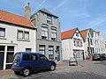 Groede, monumental houses


References
- ^ Ad van der Meer and Onno Boonstra, "Repertorium van Nederlandse gemeenten", KNAW, 2006. "Archived copy". Archived from the original on 2007-02-20. Retrieved 2009-12-03.
{{cite web}}: Unknown parameter|deadurl=ignored (|url-status=suggested) (help)CS1 maint: archived copy as title (link)
External links
 Media related to Groede at Wikimedia Commons
- Template:Kuyper Map of the former municipality in 1868.
51°23′N 3°30′E / 51.383°N 3.500°E
This article about a location in Zeeland is a stub. You can help Wikipedia by expanding it. |