
Gross, Nebraska: Difference between revisions
JJMC89 bot (talk | contribs) Migrate {{Infobox settlement}} coordinates parameters to {{Coord}}, see Wikipedia:Coordinates in infoboxes |
Rescuing 5 sources and tagging 1 as dead. #IABot (v1.3beta3) |
||
| Line 46: | Line 46: | ||
|population_as_of = [[2010 United States Census|2010]] |
|population_as_of = [[2010 United States Census|2010]] |
||
|population_est = 2 |
|population_est = 2 |
||
|pop_est_as_of = 2012<ref name="2012 Pop Estimate">{{cite web|title=Population Estimates|url=http://www.census.gov/popest/data/cities/totals/2012/SUB-EST2012.html|publisher=[[United States Census Bureau]]|accessdate=2013-05-29}}</ref> |
|pop_est_as_of = 2012<ref name="2012 Pop Estimate">{{cite web|title=Population Estimates |url=http://www.census.gov/popest/data/cities/totals/2012/SUB-EST2012.html |publisher=[[United States Census Bureau]] |accessdate=2013-05-29 |deadurl=yes |archiveurl=http://www.webcitation.org/6HQu4Spqa?url=http%3A%2F%2Fwww.census.gov%2Fpopest%2Fdata%2Fcities%2Ftotals%2F2012%2FSUB-EST2012.html |archivedate=2013-06-17 |df= }}</ref> |
||
|population_footnotes = <ref name ="FactFinder"/> |
|population_footnotes = <ref name ="FactFinder"/> |
||
|population_total = 2 |
|population_total = 2 |
||
| Line 80: | Line 80: | ||
Gross is located at {{coord|42|56|48|N|98|34|9|W|type:city}} (42.946756, -98.569233).<ref name="GR1">{{cite web|url=http://www.census.gov/geo/www/gazetteer/gazette.html|publisher=[[United States Census Bureau]]|accessdate=2011-04-23|date=2011-02-12|title=US Gazetteer files: 2010, 2000, and 1990}}</ref> |
Gross is located at {{coord|42|56|48|N|98|34|9|W|type:city}} (42.946756, -98.569233).<ref name="GR1">{{cite web|url=http://www.census.gov/geo/www/gazetteer/gazette.html|publisher=[[United States Census Bureau]]|accessdate=2011-04-23|date=2011-02-12|title=US Gazetteer files: 2010, 2000, and 1990}}</ref> |
||
According to the [[United States Census Bureau]], the village has a total area of {{convert|0.13|sqmi|sqkm|2}}, all of it land.<ref name |
According to the [[United States Census Bureau]], the village has a total area of {{convert|0.13|sqmi|sqkm|2}}, all of it land.<ref name="Gazetteer files">{{cite web|title=US Gazetteer files 2010 |url=http://www.census.gov/geo/www/gazetteer/files/Gaz_places_national.txt |publisher=[[United States Census Bureau]] |accessdate=2012-06-24 |deadurl=yes |archiveurl=http://www.webcitation.org/64vfLAeJ2?url=http%3A%2F%2Fwww.census.gov%2Fgeo%2Fwww%2Fgazetteer%2Ffiles%2FGaz_places_national.txt |archivedate=2012-01-24 |df= }}</ref> |
||
==Demographics== |
==Demographics== |
||
| Line 98: | Line 98: | ||
|estyear=2015 |
|estyear=2015 |
||
|estimate=2 |
|estimate=2 |
||
|estref=<ref name="USCensusEst2015">{{cite web|url=http://www.census.gov/popest/data/cities/totals/2015/SUB-EST2015.html|title=Annual Estimates of the Resident Population for Incorporated Places: April 1, 2010 to July 1, 2015|accessdate=July 2, 2016}}</ref> |
|estref=<ref name="USCensusEst2015">{{cite web|url=http://www.census.gov/popest/data/cities/totals/2015/SUB-EST2015.html |title=Annual Estimates of the Resident Population for Incorporated Places: April 1, 2010 to July 1, 2015 |accessdate=July 2, 2016 }}{{dead link|date=March 2017 |bot=InternetArchiveBot |fix-attempted=yes }}</ref> |
||
|align-fn=center |
|align-fn=center |
||
|footnote=U.S. Decennial Census<ref>{{cite web|url=http://www.census.gov/prod/www/decennial.html|title=Census of Population and Housing|author=[[United States Census Bureau]]|accessdate=June 23, 2013}}</ref><br>2012 Estimate<ref>{{cite web|url=http://www.census.gov/popest/data/cities/totals/2012/SUB-EST2012-3.html|title=Annual Estimates of the Resident Population: April 1, 2010 to July 1, 2012|accessdate=June 23, 2013}}</ref> |
|footnote=U.S. Decennial Census<ref>{{cite web|url=http://www.census.gov/prod/www/decennial.html |title=Census of Population and Housing |author=[[United States Census Bureau]] |accessdate=June 23, 2013 |deadurl=yes |archiveurl=http://www.webcitation.org/6YSasqtfX?url=http%3A%2F%2Fwww.census.gov%2Fprod%2Fwww%2Fdecennial.html |archivedate=May 11, 2015 |df= }}</ref><br>2012 Estimate<ref>{{cite web|url=http://www.census.gov/popest/data/cities/totals/2012/SUB-EST2012-3.html |title=Annual Estimates of the Resident Population: April 1, 2010 to July 1, 2012 |accessdate=June 23, 2013 |deadurl=yes |archiveurl=https://web.archive.org/web/20131019235623/http://www.census.gov/popest/data/cities/totals/2012/SUB-EST2012-3.html |archivedate=October 19, 2013 |df= }}</ref> |
||
}} |
}} |
||
| Line 111: | Line 111: | ||
===2000 census=== |
===2000 census=== |
||
As of the [[census]]<ref name="GR2">{{cite web|url=http://factfinder2.census.gov|publisher=[[United States Census Bureau]]|accessdate=2008-01-31|title=American FactFinder}}</ref> of 2000, there were 5 people, 1 household, and 1 family residing in the village. The [[population density]] was 38.3 people per square mile (14.9/km²). There was 1 housing unit at an average density of 7.7 per square mile (3.0/km²). The racial makeup of the village was 100.00% [[White (U.S. Census)|White]]. |
As of the [[census]]<ref name="GR2">{{cite web|url=http://factfinder2.census.gov |publisher=[[United States Census Bureau]] |accessdate=2008-01-31 |title=American FactFinder |deadurl=yes |archiveurl=https://web.archive.org/web/20130911234518/http://factfinder2.census.gov/ |archivedate=2013-09-11 |df= }}</ref> of 2000, there were 5 people, 1 household, and 1 family residing in the village. The [[population density]] was 38.3 people per square mile (14.9/km²). There was 1 housing unit at an average density of 7.7 per square mile (3.0/km²). The racial makeup of the village was 100.00% [[White (U.S. Census)|White]]. |
||
There was 1 household, a [[Marriage|married couple]] living together, with children under the age of 18 living with them. Consequently, the average household size and the average family size was 5.00. |
There was 1 household, a [[Marriage|married couple]] living together, with children under the age of 18 living with them. Consequently, the average household size and the average family size was 5.00. |
||
Revision as of 15:33, 25 March 2017
Gross, Nebraska | |
|---|---|
 Downtown Gross | |
 Location of Gross, Nebraska | |
| Coordinates: 42°56′48″N 98°34′9″W / 42.94667°N 98.56917°W | |
| Country | United States |
| State | Nebraska |
| County | Boyd |
| Area | |
| • Total | 0.13 sq mi (0.34 km2) |
| • Land | 0.13 sq mi (0.34 km2) |
| • Water | 0 sq mi (0 km2) |
| Elevation | 1,775 ft (541 m) |
| Population | |
| • Total | 2 |
| • Estimate (2012[3]) | 2 |
| • Density | 15.4/sq mi (5.9/km2) |
| Time zone | UTC-6 (Central (CST)) |
| • Summer (DST) | UTC-5 (CDT) |
| FIPS code | 31-20295 |
| GNIS feature ID | 0829703[4] |
Gross is a village in Boyd County, Nebraska, United States. As of the 2010 census, the village had a total population of two, down from its 2000 population of five.[5] In the 2000 United States Census, it was one of only eight places with a population of five people. The others were Storrie, California; Bear Head Lake, Minnesota; Baker, Missouri; Odell, New Hampshire; Maza, North Dakota; Somerset, Vermont, and Prudhoe Bay, Alaska.
History
Gross was founded in 1893.[6] It was named for Ben Gross, who kept a general store.[7]
Geography
Gross is located at 42°56′48″N 98°34′9″W / 42.94667°N 98.56917°W (42.946756, -98.569233).[8]
According to the United States Census Bureau, the village has a total area of 0.13 square miles (0.34 km2), all of it land.[1]
Demographics
| Census | Pop. | Note | %± |
|---|---|---|---|
| 1900 | 325 | — | |
| 1910 | 111 | −65.8% | |
| 1920 | 84 | −24.3% | |
| 1930 | 51 | −39.3% | |
| 1940 | 23 | −54.9% | |
| 1950 | 29 | 26.1% | |
| 1960 | 17 | −41.4% | |
| 1970 | 8 | −52.9% | |
| 1980 | 2 | −75.0% | |
| 1990 | 7 | 250.0% | |
| 2000 | 5 | −28.6% | |
| 2010 | 2 | −60.0% | |
| 2015 (est.) | 2 | [9] | 0.0% |
| U.S. Decennial Census[10] 2012 Estimate[11] | |||
2010 census
As of the census[2] of 2010, there were 2 people, 1 household, and 1 family residing in the village. The population density was 15.4 inhabitants per square mile (5.9/km2). There were 4 housing units at an average density of 30.8 per square mile (11.9/km2). The racial makeup of the village was 100.0% White.
There was 1 household of which 100.0% were married couples living together. 0.0% of all households were made up of individuals. The average household size was 2.00 and the average family size was 2.00.
The median age in the village was 49 years. 0.0% of residents were under the age of 18; 0.0% were between the ages of 18 and 24; 0.0% were from 25 to 44; 100% were from 45 to 64; and 0.0% were 65 years of age or older. The gender makeup of the village was 50.0% male and 50.0% female.
2000 census
As of the census[12] of 2000, there were 5 people, 1 household, and 1 family residing in the village. The population density was 38.3 people per square mile (14.9/km²). There was 1 housing unit at an average density of 7.7 per square mile (3.0/km²). The racial makeup of the village was 100.00% White.
There was 1 household, a married couple living together, with children under the age of 18 living with them. Consequently, the average household size and the average family size was 5.00.
In the village, the population was spread out with 20.0% under the age of 18, 40.0% from 18 to 24, 20.0% from 25 to 44, and 20.0% who were 45 to 64 years old. The median age was 22 years. For every 100 females there were 150.0 males. For every 100 females age 18 and over, there were 100.0 males.
-
-

-
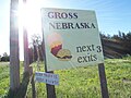
 Sign listing the population as 3


References
- ^ a b "US Gazetteer files 2010". United States Census Bureau. Archived from the original on 2012-01-24. Retrieved 2012-06-24.
{{cite web}}: Unknown parameter|deadurl=ignored (|url-status=suggested) (help) - ^ a b "American FactFinder". United States Census Bureau. Retrieved 2012-06-24.
- ^ "Population Estimates". United States Census Bureau. Archived from the original on 2013-06-17. Retrieved 2013-05-29.
{{cite web}}: Unknown parameter|deadurl=ignored (|url-status=suggested) (help) - ^ "US Board on Geographic Names". United States Geological Survey. 2007-10-25. Retrieved 2008-01-31.
- ^ "American FactFinder". U.S. Census Bureau. Retrieved 4 March 2011.
- ^ "Gross, Boyd County". Center for Advanced Land Management Information Technologies. University of Nebraska. Retrieved 30 July 2014.
- ^ "12 U.S. places where your visit could double the population". Mother Nature Network. Retrieved 2 May 2014.
- ^ "US Gazetteer files: 2010, 2000, and 1990". United States Census Bureau. 2011-02-12. Retrieved 2011-04-23.
- ^ "Annual Estimates of the Resident Population for Incorporated Places: April 1, 2010 to July 1, 2015". Retrieved July 2, 2016.[permanent dead link]
- ^ United States Census Bureau. "Census of Population and Housing". Archived from the original on May 11, 2015. Retrieved June 23, 2013.
{{cite web}}: Unknown parameter|deadurl=ignored (|url-status=suggested) (help) - ^ "Annual Estimates of the Resident Population: April 1, 2010 to July 1, 2012". Archived from the original on October 19, 2013. Retrieved June 23, 2013.
{{cite web}}: Unknown parameter|deadurl=ignored (|url-status=suggested) (help) - ^ "American FactFinder". United States Census Bureau. Archived from the original on 2013-09-11. Retrieved 2008-01-31.
{{cite web}}: Unknown parameter|deadurl=ignored (|url-status=suggested) (help)
Municipalities and communities of Boyd County, Nebraska, United States | ||
|---|---|---|
| Villages |  | |
| Townships | ||
| Ghost towns | ||