Hurricane River: Difference between revisions
Appearance
Content deleted Content added
m Update parameter syntax per Bot Task 7 |
Rescuing 1 sources and tagging 0 as dead. #IABot (v1.3beta4) |
||
| Line 16: | Line 16: | ||
| basin_size = |
| basin_size = |
||
}} |
}} |
||
The '''Hurricane River''' is a {{convert|6.4|mi|km|adj=mid|-long}}<ref name=NHD>U.S. Geological Survey. National Hydrography Dataset high-resolution flowline data. [http://viewer.nationalmap.gov/viewer/ The National Map], accessed January 3, 2012</ref> river in [[Alger County, Michigan|Alger County]] in the [[Upper Peninsula]] of [[Michigan]] in the [[United States]]. It empties into [[Lake Superior]] in the [[Pictured Rocks National Lakeshore]]. There is a campground at the mouth of the river which is also the beginning of a trail that leads past various old shipwrecks to the historic [[Au Sable Lighthouse]].<ref>Pure Michigan [http://www.michigan.org/Property/Detail.aspx?p=B4107] accessed March 25, 2011</ref> The mouth of the river is also very near the eastern end of a stretch of relatively straight shoreline known as [[Twelvemile Beach]]. |
The '''Hurricane River''' is a {{convert|6.4|mi|km|adj=mid|-long}}<ref name=NHD>U.S. Geological Survey. National Hydrography Dataset high-resolution flowline data. [http://viewer.nationalmap.gov/viewer/ The National Map] {{webarchive|url=http://www.webcitation.org/66gupqQDM?url=http%3A%2F%2Fviewer.nationalmap.gov%2Fviewer%2F |date=2012-04-05 }}, accessed January 3, 2012</ref> river in [[Alger County, Michigan|Alger County]] in the [[Upper Peninsula]] of [[Michigan]] in the [[United States]]. It empties into [[Lake Superior]] in the [[Pictured Rocks National Lakeshore]]. There is a campground at the mouth of the river which is also the beginning of a trail that leads past various old shipwrecks to the historic [[Au Sable Lighthouse]].<ref>Pure Michigan [http://www.michigan.org/Property/Detail.aspx?p=B4107] accessed March 25, 2011</ref> The mouth of the river is also very near the eastern end of a stretch of relatively straight shoreline known as [[Twelvemile Beach]]. |
||
{| |
{| |
||
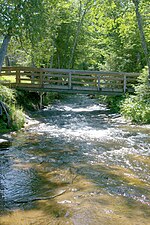
| [[File:Hurricane River MI2.jpg|thumb|150px|alt=Hurricane River near mouth |Hurricane River near the mouth]] |
| [[File:Hurricane River MI2.jpg|thumb|150px|alt=Hurricane River near mouth |Hurricane River near the mouth]] |
||
Revision as of 00:02, 7 April 2017
| Hurricane River | |
|---|---|
 Mouth of the Hurricane River at Lake Superior | |
| Physical characteristics | |
| Source | |
| • location | Burt Township, Alger County, Michigan |
| • coordinates | 46°36′19″N 86°05′46″W / 46.60525°N 86.096°W[1] |
| Mouth | |
• location | Lake Superior, Michigan |
• coordinates | 46°39′58″N 86°10′05″W / 46.66607°N 86.16794°W |
| Length | 6.4 mi (10.3 km) |
The Hurricane River is a 6.4-mile-long (10.3 km)[2] river in Alger County in the Upper Peninsula of Michigan in the United States. It empties into Lake Superior in the Pictured Rocks National Lakeshore. There is a campground at the mouth of the river which is also the beginning of a trail that leads past various old shipwrecks to the historic Au Sable Lighthouse.[3] The mouth of the river is also very near the eastern end of a stretch of relatively straight shoreline known as Twelvemile Beach.
 |
 |
See also
References
- ^ "Hurricane River". Geographic Names Information System. United States Geological Survey, United States Department of the Interior.
- ^ U.S. Geological Survey. National Hydrography Dataset high-resolution flowline data. The National Map Archived 2012-04-05 at WebCite, accessed January 3, 2012
- ^ Pure Michigan [1] accessed March 25, 2011
External links
Wikimedia Commons has media related to Hurricane River.
- Michigan Streamflow Data from the USGS
- Information on campgrounds in the Pictured Rocks National Lakeshore
