
Yellowstone Lake: Difference between revisions
m +infobox lake |
CamperStrike (talk | contribs) No edit summary |
||
| Line 47: | Line 47: | ||
The Hayden Valley was once filled by an arm of Yellowstone Lake. Therefore, it contains fine-grained [[lake sediment]]s that are now covered with [[glacial till]] left from the most recent [[glacier|glacial]] retreat 13,000 years ago. Because the glacial till contains many different grain sizes, including clay and a thin layer of lake sediments, water cannot percolate readily into the ground. This is why the Hayden Valley is [[marsh]]y and has little encroachment of [[tree]]s. |
The Hayden Valley was once filled by an arm of Yellowstone Lake. Therefore, it contains fine-grained [[lake sediment]]s that are now covered with [[glacial till]] left from the most recent [[glacier|glacial]] retreat 13,000 years ago. Because the glacial till contains many different grain sizes, including clay and a thin layer of lake sediments, water cannot percolate readily into the ground. This is why the Hayden Valley is [[marsh]]y and has little encroachment of [[tree]]s. |
||
<center> |
|||
<gallery> |
|||
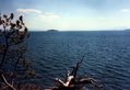
Image:ynp-lake-2004.jpg|Yellowstone Lake |
|||
Image:YellowstoneLake.jpg|Yellowstone Lake |
|||
Image:LakeGeysir.jpg|Geyser at the Yellowstone Lake |
|||
</gallery> |
|||
</center> |
|||
==Reference== |
==Reference== |
||
*[http://www.nps.gov/yell/nature/geology/geolake.htm National Park Service - Geological Overview of Yellowstone Lake] (adapted public domain text) |
*[http://www.nps.gov/yell/nature/geology/geolake.htm National Park Service - Geological Overview of Yellowstone Lake] (adapted public domain text) |
||
Revision as of 19:47, 27 November 2006
| Yellowstone Lake | |
|---|---|
| Coordinates | 44°25′N 110°22′W / 44.417°N 110.367°W |
| Primary outflows | Yellowstone River |
| Basin countries | USA |
| Surface area | 136 sq mi |
| Average depth | 139 ft (42 m) |
| Max. depth | 387 ft (118 m) |
| Surface elevation | 7732 ft (2376 m) |
Yellowstone Lake is the largest body of water in Yellowstone National Park, The lake is 7,732 feet (2,376 m) above sea level and covers 136 square miles with 110 miles (177 km) of shoreline. While the average depth of the lake is 139 feet (42 m) its deepest spot is 387 feet (118 m). After Lake Titicaca in South America, Yellowstone Lake is the largest high altitude freshwater lake in the world.
In winter, ice nearly 3 feet (1 m) thick covers much of the lake, except where shallow water covers hot springs. The lake freezes over by early December and can remain frozen until late May or early June.
Geology

In the southwest area of the lake the West Thumb geothermal area is easily accessible to visitors. Geysers, fumaroles and hot springs are found alongside and even in the lake. See Geothermal areas of Yellowstone.
In recent years (as of 2004), the ground under the lake has started to rise significantly, indicating increased geological activity, and limited areas of the national park have been closed to the public. As of 2005, no areas are currently off limits aside from those normally allowing limited access such as around the West Thumb Geyser Basin. There is a 'bulge' about 2000 feet (600m) long and 100 feet (30m) high under a section of Yellowstone Lake, where there are a variety of faults, hot springs and small craters. Seismic imaging has recently shown that sediment layers are tilted, but how old this feature is has not yet been established.

After the magma chamber under the Yellowstone area collapsed 600,000 years ago in its previous great eruption, it formed a large caldera that was later partially filled by subsequent lava flows (see Yellowstone Caldera). Part of this caldera is the 136 square mile (352 km²) basin of Yellowstone Lake. The original lake was 200 ft. (60m) higher than the present-day lake, extending northward across Hayden Valley to the base of Mt. Washburn.
It is thought that Yellowstone Lake originally drained south into the Pacific Ocean via the Snake River. The lake currently drains north from its only outlet, the Yellowstone River, at Fishing Bridge. The elevation of the lake's north end does not drop substantially until LeHardy Rapids. Therefore, this spot is considered the actual northern boundary of Yellowstone Lake. Within a short distance downstream the Yellowstone River plunges first over the upper and then the lower falls and races north through the Grand Canyon of the Yellowstone.

In the 1990s, geological research has determined that the two volcanic vents, now known as "resurgent domes", are rising again. From year to year, they either rise or fall, with an average net uplift of about one inch per year. During the period between 1923 and 1985, the Sour Creek Dome was rising. In the years since 1986, it has either declined or remained the same. The resurgence of the Sour Creek dome, just north of Fishing Bridge is causing Yellowstone Lake to "tilt" southward. Larger sandy beaches can now be found on the north shore of the lake, and flooded areas can be found in the southern arms.
The Hayden Valley was once filled by an arm of Yellowstone Lake. Therefore, it contains fine-grained lake sediments that are now covered with glacial till left from the most recent glacial retreat 13,000 years ago. Because the glacial till contains many different grain sizes, including clay and a thin layer of lake sediments, water cannot percolate readily into the ground. This is why the Hayden Valley is marshy and has little encroachment of trees.
-
 Yellowstone Lake
 -
 Yellowstone Lake
 -
 Geyser at the Yellowstone Lake


Reference
- National Park Service - Geological Overview of Yellowstone Lake (adapted public domain text)