Esso (village)
Esso
Эссо | |
|---|---|
 | |
| Coordinates: 55°55′50″N 158°41′41″E / 55.93056°N 158.69472°E | |
| Country | Russia |
| Federal subject | Kamchatka Krai |
| Population | |
| • Estimate (2021)[1] | 1,879 |
| Time zone | UTC+12 (MSK+9 |
| Postal code(s)[3] | |
| OKTMO ID | 30604401101 |
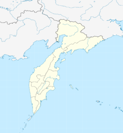
Esso (Russian: Эссо) is a village in Kamchatka Krai, Russia. It is the administrative centre of Bystrinsky District.[4] It has been described as one of the most scenic villages in Russia.[5]
Geography
Esso is located in the central part of the Kamchatka Peninsula. It is roughly 319km from Petropavlovsk-Kamchatsky,[6] and roughly 6,529km from Moscow.[7] It is located at the convergence of the Bystraya and Uksichan Rivers.[8][9]
Attractions
Esso has multiple notable sites, making it attractive to tourists.[10] These include hot springs near the edge of the village, with temperatures often reaching 65°C.[10] Thermal springs also heat an outdoor swimming pool in the central part of the village.[10] In addition to its hot springs, Esso is home to Kamchatka's only ethnographic museum.[11] The museum documents the traditions and architecture of the indigenous Even and Koryak peoples, as well as those of Russian and Cossack settlers.[12]
Climate
Esso's climate can be classified as subarctic, or Dfc under the Köppen climate classification.[13][14]
| Climate data for Esso | |||||||||||||
|---|---|---|---|---|---|---|---|---|---|---|---|---|---|
| Month | Jan | Feb | Mar | Apr | May | Jun | Jul | Aug | Sep | Oct | Nov | Dec | Year |
| Record high °F (°C) | 41.4 (5.2) |
45.0 (7.2) |
47.3 (8.5) |
62.2 (16.8) |
75.6 (24.2) |
86.2 (30.1) |
90.0 (32.2) |
86.5 (30.3) |
79.0 (26.1) |
65.7 (18.7) |
51.4 (10.8) |
51.4 (10.8) |
90.0 (32.2) |
| Mean daily maximum °F (°C) | 9.3 (−12.6) |
15.8 (−9.0) |
24.6 (−4.1) |
35.1 (1.7) |
49.1 (9.5) |
62.8 (17.1) |
68.7 (20.4) |
64.4 (18.0) |
54.1 (12.3) |
39.9 (4.4) |
23.5 (−4.7) |
11.3 (−11.5) |
38.2 (3.5) |
| Daily mean °F (°C) | −0.9 (−18.3) |
3.4 (−15.9) |
30.0 (−1.1) |
25.3 (−3.7) |
39.2 (4.0) |
51.3 (10.7) |
57.4 (14.1) |
53.8 (12.1) |
43.7 (6.5) |
31.5 (−0.3) |
15.3 (−9.3) |
2.8 (−16.2) |
29.4 (−1.5) |
| Mean daily minimum °F (°C) | −9.6 (−23.1) |
−6.7 (−21.5) |
0.9 (−17.3) |
15.6 (−9.1) |
29.3 (−1.5) |
39.2 (4.0) |
46.2 (7.9) |
44.2 (6.8) |
34.5 (1.4) |
24.6 (−4.1) |
7.5 (−13.6) |
−4.9 (−20.5) |
18.4 (−7.5) |
| Record low °F (°C) | −44.3 (−42.4) |
−42.2 (−41.2) |
−40.4 (−40.2) |
−23.1 (−30.6) |
1.4 (−17.0) |
22.1 (−5.5) |
26.1 (−3.3) |
21.6 (−5.8) |
10.9 (−11.7) |
−6.0 (−21.1) |
−24.7 (−31.5) |
−37.1 (−38.4) |
−44.3 (−42.4) |
| Average precipitation inches (mm) | 0.7 (18) |
0.7 (17) |
0.7 (19) |
0.5 (12) |
0.8 (20) |
1.5 (39) |
2.6 (66) |
2.7 (69) |
1.6 (40) |
1.4 (35) |
1.3 (33) |
0.8 (21) |
15.3 (389) |
| Source: pogodaiklimat.ru[14] | |||||||||||||
- ^ "Численность постоянного населения Российской Федерации по муниципальным образованиям на 1 января 2021 года". January 1, 2021.
{{cite web}}: CS1 maint: url-status (link) - ^ "Об исчислении времени". Официальный интернет-портал правовой информации (in Russian). 3 June 2011. Retrieved 19 January 2019.
- ^ Почта России. Информационно-вычислительный центр ОАСУ РПО. (Russian Post). Поиск объектов почтовой связи (Postal Objects Search) (in Russian)
- ^ "Быстринский муниципальный район, краткая историко-географическая характеристика". essobmr.ru. Retrieved 2021-07-09.
- ^ "14 Most Scenic Small Towns In Russia". Touropia. Retrieved 2021-07-09.
- ^ "Google Earth". earth.google.com. Retrieved 2021-07-09.
- ^ "Google Earth". earth.google.com. Retrieved 2021-07-09.
- ^ Otsuki, Yoshinori (March 2009). "Glacial Landforms and Deposits in the Uksichan River Valley, Central Kamchatka, Russia". ResearchGate. Retrieved 2021-07-09.
{{cite web}}: CS1 maint: url-status (link) - ^ "Google Earth". earth.google.com. Retrieved 2021-07-09.
- ^ a b c "Esso". kamchatkaland.com. Retrieved 2021-07-09.
- ^ Costine, Kelly. "Ethnographic museum in the village of Esso (Ethnographic museum) description and photos - Russia - Far East: Esso". Useful Articles About Traval For Tourists. Description Of The Countries, Health Resorts. Retrieved 2021-07-09.
{{cite web}}: CS1 maint: url-status (link) - ^ Costine, Kelly. "Ethnographic museum in the village of Esso (Ethnographic museum) description and photos - Russia - Far East: Esso". Useful Articles About Traval For Tourists. Description Of The Countries, Health Resorts. Retrieved 2021-07-09.
{{cite web}}: CS1 maint: url-status (link) - ^ Arnfield, A. John (November 11, 2020). "Koppen climate classification | Definition, System, & Map". Encyclopedia Britannica. Retrieved 2021-07-09.
{{cite web}}: CS1 maint: url-status (link) - ^ a b "Климат Эссо - Погода и климат". www.pogodaiklimat.ru. Retrieved 2021-07-09.
This article, Esso (village), has recently been created via the Articles for creation process. Please check to see if the reviewer has accidentally left this template after accepting the draft and take appropriate action as necessary.
Reviewer tools: Inform author |
References
This article, Esso (village), has recently been created via the Articles for creation process. Please check to see if the reviewer has accidentally left this template after accepting the draft and take appropriate action as necessary.
Reviewer tools: Inform author |


