Aufhof
Appearance
This article, Aufhof, has recently been created via the Articles for creation process. Please check to see if the reviewer has accidentally left this template after accepting the draft and take appropriate action as necessary.
Reviewer tools: Inform author |
This article, Aufhof, has recently been created via the Articles for creation process. Please check to see if the reviewer has accidentally left this template after accepting the draft and take appropriate action as necessary.
Reviewer tools: Inform author |
 Comment: Unsourced KylieTastic (talk) 20:54, 19 June 2021 (UTC)
Aufhof | |
|---|---|
Local community | |
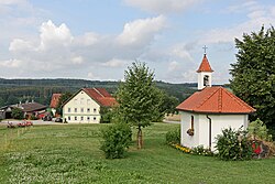
 Courtyard with Maria Trost chapel | |
| Country | Germany |
| State | Bavaria |
| Time zone | UTC+01:00 (CET) |
| • Summer (DST) | UTC+02:00 (CEST) |
Aufhof is a district of the Upper Swabian municipality of Eppishausen in the Unterallgäu district.
Location
The single settlement is about six kilometers northeast of the main town and is connected to it via the state road St 2027 and the county road MN 3. It originally belonged to the municipality of Könghausen and was incorporated into the municipality of Eppishausen on July 1, 1972 as part of the regional reforms in Bavaria.[1]
Notes
- Hermann Haisch, ed. (1987), Landkreis Unterallgäu (in German), Memmingen: Memminger Zeitung Verlagsdruckerei, p. 982, ISBN 3980064921
{{citation}}: CS1 maint: date and year (link)
References
- ^ Wilhelm Volkert (Hrsg.): Handbuch der bayerischen Ämter, Gemeinden und Gerichte 1799–1980. C. H. Beck, München 1983, ISBN 3-406-09669-7, S. 524.
This article, Aufhof, has recently been created via the Articles for creation process. Please check to see if the reviewer has accidentally left this template after accepting the draft and take appropriate action as necessary.
Reviewer tools: Inform author |


