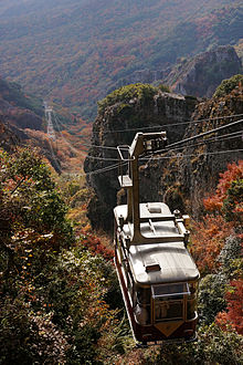
Kankakei Ropeway
Appearance
| Kankakei Ropeway | |
|---|---|
 | |
| Overview | |
| Status | Operational |
| Character | Aerial tramway |
| Location | Kankakei (a gorge on Shōdoshima Island) in Shōdoshima, Kagawa, Japan |
| No. of stations | 2 |
| Open | 1963 |
| Operation | |
| Carrier capacity | 40 Passengers per cabin, 2 cabins |
| Trip duration | 5 min |
| Technical features | |
| Line length | 917 m (3,009 ft) |
| No. of cables | 3 |
| Vertical Interval | 312 m (1,024 ft) |
The Kankakei Ropeway (寒霞渓ロープウェイ, Kankakei Rōpuwei) is a Japanese aerial lift line in Shōdoshima, Kagawa. This is the only line operated by Shōdoshima Sōgō Kaihatsu (小豆島総合開発, "Shōdoshima General Development"). The line opened in 1963. It runs through Kankakei, a gorge on Shōdoshima Island. The gorge is known for its unique view, made by diastrophisms and erosions.
Basic data
See also
External links
- (in Japanese) Official website
Wikimedia Commons has media related to Kankakei Ropeway.
34°30′55.6″N 134°18′2.1″E / 34.515444°N 134.300583°E
