Bungtang
Appearance
Bungtang
बुङताङ | |
|---|---|
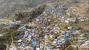
 Bungtang (Captured February 2020 ) | |
| Coordinates: 28°00′N 85°06′E / 28.00°N 85.10°E | |
| Country | |
| Zone | Bagmati Zone |
| District | Nuwakot District |
| Population (1991) | |
| • Total | 2,269 |
| Time zone | UTC+5:45 (Nepal Time) |
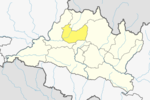
Bungtang (Currently Myagang Rural Municipality Ward no.2) बुङताङ is a village development committee in Nuwakot District in the Bagmati Zone (Bagmati Province ) of central Nepal. At the time of the 2011 Nepal census it had a population of 3288 living in 743 individual households.[1]
The original name of the village was "Bomtang". In Bhot language "Bomo" बोमो means Daughter or female "Tang" तङ means "being happy". "Bomtang" was such a beautiful place that women/female used to be happy when they come here. Hence the name "Bomtang". Later as it passed on was written Bungtang(बुङताङ).
References
- ^ "Nepal Census 2001", Nepal's Village Development Committees, Digital Himalaya, archived from the original on 12 October 2008, retrieved 15 November 2009.
External links


