
Oued El Alleug
Ouled El Alleug
واد العلايق | |
|---|---|
Commune and town | |
.jpg) Oued El Alleug | |
| Country | |
| Province | Blida Province |
| Elevation | 154 ft (47 m) |
| Population (1998) | |
| • Total | 33,915 |
| • Density | 990/sq mi (383/km2) |
| Time zone | UTC+1 (CET) |
Ouled El Alleug is a town and commune in Blida Province, Algeria. It is at 36.55528°N 2.79028°E. According to the 1998 census it has a population of 33,915.[1] The population density is 383 persons per kilometer.[2]
The height of Oued el Alleug is 47 meters above sea level.[3] The land around the Oued el Alleug with mostly flat, but to the northern-west are hills. February is the wettest month, with an average of 169mm of rain, while June is almost completely dry.
-
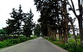 Oued El Alleug panorama
 -
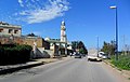 Oued El Alleug
.jpg)

References
[edit]- ^ Statoids
- ^ Oued el Alleug at population maps, NASA.
- ^ Oued el Alleug at Geonames.org.
| Blida District | .svg) | |
|---|---|---|
| Boufarik District | ||
| El Affroun District | ||
| Larbaâ District | ||
| Ouled Yaïch District | ||
| Bouinan District | ||
| Bougara District | ||
| Oued El Alleug District | ||
| Mouzaïa District | ||
| Meftah District | ||
36°33′N 2°47′E / 36.550°N 2.783°E
This article about a location in Blida Province is a stub. You can help Wikipedia by expanding it. |