
Rottachberg
| Rottachberg | |
|---|---|
 Rottachberg | |
| Highest point | |
| Elevation | 1,115 m (3,658 ft) |
| Prominence | 275 m ↓ Kalchenbach |
| Isolation | 3 km → Grünten |
| Coordinates | 47°35′28″N 10°17′35″E / 47.591°N 10.293°E |
| Geography | |
| Parent range | Allgäu Alps |
| Geology | |
| Type of rock | Molasse (Nagelfluh) |

The Rottachberg is a 1115 m high mountain in the Allgäu Alps near Rettenberg. Its summit is known as Falkenstein.
-
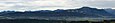 Rottachberg and Grünten from Stoffelberg
 -
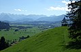
 Rottachberg from Grünten
 -
 Falkenstein at Rottachberg
 -
 Pavilion on Gebhardshöhe


Ascend
[edit]Two and a half hours walk from Rettenberg to Falkenstein and back.[1] The Falkenstein is a challenging climbing area with UIAA grades VII to XI.[2]
References
[edit]This Bavaria location article is a stub. You can help Wikipedia by expanding it. |