Hand, South Carolina
Appearance
Hand, South Carolina | |
|---|---|
| Country | United States |
| State | South Carolina |
| County | Horry |
| Time zone | Eastern |
| ZIP Code | 29526, 29568 |
| Area code | 843 |
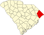
Hand is an unincorporated community in Horry County, South Carolina, United States.[1] Hand is located along SC 90 between Conway and Wampee.
History[edit]
A post office called Hand was established in 1888, and remained in operation until 1942.[2] The origin of the name "Hand" is obscure.[3]
References[edit]
- ^ U.S. Geological Survey Geographic Names Information System: Hand, South Carolina
- ^ "Post Offices". Jim Forte Postal History. Retrieved January 5, 2017.
- ^ Moyer, Armond; Moyer, Winifred (1958). The origins of unusual place-names. Keystone Pub. Associates. pp. 141–142.
33°51′22″N 78°48′26″W / 33.85611°N 78.80722°W

