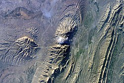
Salt dome


A salt dome is formed when a thick bed of evaporite minerals (mainly salt, or halite) found at depth intrudes vertically into surrounding rock strata, forming a diapir.
The salt that forms these deposits was laid within restricted marine basins. Due to this restricted flow of water into the basin, evaporation occurred resulting in the precipitation-out of salts from solution, depositing evaporite's. It is recognised that a single evaporation event is rarely enough to produce the vast quanities of salt found in evaporite deposits indicating that a sustained period of episodic flooding and evaportation of the basin must have occurred, as can be seen from the example of the Mediterranean Messinian salinity crisis. At the present day evaporite deposits can be seen to be accummulating in basins that merely have restricted access but do not completely dry out and provided an analogue to some deposits recognised in the Geological Record, such as the Garabogazköl basin in Turkmenistan.
Over time, the salt is covered with sediment and becomes buried. Since the density of salt is generally less than that of surrounding material, it has a tendency to move upward toward the surface, forming large bulbous domes, diapirs , sheets, pillars and other structures as it rises. If the rising salt diapir breaches the surface, it can become a flowing salt glacier. In cross section, these large domes may be anywhere from 1 to 10 kilometers across and extend as far down as 6.5 kilometers.
One example of an island formed by a salt dome is Avery Island in Louisiana, except for the fact that at present ocean levels, it's no longer an island and is located 3 miles inland.
The term "salt dome" is also sometimes inaccurately used to refer to dome-shaped silos used to store rock salt for melting snow on highways.
Commercial uses
The rock salt that is found in salt domes is mostly impermeable. As the salt moves up towards the surface, it can penetrate and/or bend strata of existing rock with it. As these strata are penetrated, they are generally bent slightly upwards at the point of contact with the dome, and can form pockets where petroleum and natural gas can collect between impermeable strata of rock and the salt. The strata immediately above the dome that are not penetrated are pushed upward, creating a dome-like reservoir above the salt where petroleum can also gather. These oil pools can eventually be extracted, and indeed form a major source of the petroleum produced along the coast of the Gulf of Mexico.
Other uses include storing oil, gas, or even hazardous waste in large caverns formed after salt mining, as well as excavating the domes themselves for uses in everything from table salt to the granular material used to prevent roadways from icing over.
See also
External links
- Salt dome at Schlumberger's Oilfield Glossary
- Hattiesburg Mississippi Salt Domes interactive map of domes use to store LPG and other gas
