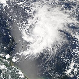
Hurricane Philippe (2005)
| Category 1 hurricane (SSHWS/NWS) | |
 Philippe at peak intensity | |
| Formed | September 17, 2005 |
|---|---|
| Dissipated | September 23, 2005 |
| Highest winds | 1-minute sustained: 80 mph (130 km/h) |
| Lowest pressure | 985 mbar (hPa); 29.09 inHg |
| Fatalities | None reported |
| Damage | None |
| Areas affected | No land areas |
| Part of the 2005 Atlantic hurricane season | |
Hurricane Phillippe was a short-lived hurricane that formed over the Atlantic in September during the 2005 Atlantic hurricane season. Philippe was the sixteenth named storm and ninth hurricane of the season.
Hurricane Philippe initially formed to the east of the Lesser Antilles on September 17 and moved to the north strengthening as it did so. Philippe became a hurricane on September 18 and stayed as such for two days before increasing wind shear from a non-tropical system took its toll on September 20 and weakened Philippe into a tropical storm. Philippe continued to weaken as it looped around this low and was absorbed by it on September 23.
Storm history

Tropical storm (39–73 mph, 63–118 km/h)
Category 1 (74–95 mph, 119–153 km/h)
Category 2 (96–110 mph, 154–177 km/h)
Category 3 (111–129 mph, 178–208 km/h)
Category 4 (130–156 mph, 209–251 km/h)
Category 5 (≥157 mph, ≥252 km/h)
Unknown
On September 9 a tropical wave moved off the African coast and moved west into the Atlantic. It started to become more organized on September 13 and the National Hurricane Center began to watch it closely for further development. Tropical Depression Seventeen formed from the wave on September 17 when it was 350 miles (560 km) east of Barbados.[1] The depression strengthened further to become Tropical Storm Philippe that evening, and the official forecasts correctly indicated that Philippe would move northwards and not approach the Lesser Antilles despite climatology suggesting an impact on the islands.[1]
Philippe continued to steadily strengthen, becoming a hurricane late on September 18 as it traveled north in a low-shear environment and some models suggested that this trend would continue and Philippe would go on to become a major hurricane.[2] However Philippe began to encounter higher wind shear from a non-tropical low, the development of which partly resulted from Hurricane Rita's outflow. As a result of this shear Philippe's winds only managed to reach a peak of 80 mph (130 km/h) before Philippe weakened back into a tropical storm on September 20.[1]
Philippe moved farther north skirting the low and Philippe continued to weaken gradually. The official forecast did not predict this, primarily as a result of some models indicating a reintensification to hurricane status.[3] Philippe began to loop around the center of the non-tropical system, weakening as it did so. As Philippe turned towards Bermuda it weakened into a tropical depression on September 22. The depression degenerated into a remnant low the next day and this remnant continued to loop cyclonically and could be tracked for a further day or two within the circulation of the non-tropical system.[1]
Preparations, impact, and naming
Despite forming fairly close to the Lesser Antilles, no tropical cyclone warnings were issued for the islands, as the official forecast correctly foresaw that Philippe would stay well to the east. A tropical storm warning was issued for Bermuda on September 23, but proved redundant when Philippe dissipated well to the south of the island.[1] The storm still brought gusty winds and moisture to the island, with 0.15 inches (3.8 mm) of precipitation reported on September 23. The circulation that absorbed Philippe dropped light rainfall on the island, and was responsible for the lowest barometric pressure during the month.[4]
When Tropical Storm Philippe formed on September 17, it was the earliest ever in the season that the sixteenth storm formed, beating the previous record held by Storm 16 of the 1933 season by 10 days. Philippe was only the third Atlantic storm to be named with the letter 'P'; the other two were Pablo in 1995 and Peter in 2003.[5] Due to the lack of major effects from Hurricane Philippe, the name was not retired by the World Meteorological Organization and will be on the list of names for the 2011 season.
See also
References
- ^ a b c d e National Hurricane Center. "Tropical Cyclone Report: Hurricane Philippe" (PDF). NOAA. Retrieved April 29.
{{cite web}}: Check date values in:|accessdate=(help); Unknown parameter|accessyear=ignored (|access-date=suggested) (help) - ^ National Hurricane Center. "Discussion for Hurricane Philippe, 5:00 a.m. EDT, September 19 2005". NOAA. Retrieved April 29.
{{cite web}}: Check date values in:|accessdate=(help); Unknown parameter|accessyear=ignored (|access-date=suggested) (help) - ^ National Hurricane Center. "Discussion for Tropical Storm Philippe, 11:00 a.m. EDT, September 21 2005". NOAA. Retrieved April 29.
{{cite web}}: Check date values in:|accessdate=(help); Unknown parameter|accessyear=ignored (|access-date=suggested) (help) - ^ Bermuda Weather Service (2005). "Weather Summary for September 2005". Retrieved 2008-04-24.
- ^ Hurricane Research Division (2007). "Atlantic Hurricane Best Track (1851-2006)". NOAA. Retrieved 2008-04-24.

