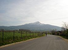
Ljuboten

Ljuboten (Macedonian: Љуботен, Ljuboten; Serbian: Љуботан, Ljubotan; Albanian: Luboteni) is a peak of the Šar Mountains located at the border between Republic of Macedonia and Kosovo. Its height is 2498 meters.
Information
At the Macedonian side of the peak are located several interesting places: a mountain house called "Ljuboten", Shija Ljubotenska (English: Ljuboten's Neck), Kozja Karpa (Goat's Rock), Shiljast Kamen (Pointed Rock), and Rogacevski Korita.
Ljuboten is a favorite destination of many mountain climbers from Europe. Its terrain is rich with pastures, but there are also rocky outcroppings. Livadicko Ezero (Livadica Lake) and few sheepfolds are near the peak. In wintertime there is usually over a meter of snow on the ground at Ljuboten.
The mountain house at Ljuboten is located in the foothills of the peak and is connected with a road to Vratnica. It takes two or three hours to drive from Vratnica to the Ljuboten mountain house. This house is open from March till November and offers room and board for 80-100 people.
Every year at Ilinden (2nd of August), the national holiday of Macedonia, more than 200 people enjoy the untouched nature of Ljuboten and the Šar Mountains.
The peak has been nicknamed "Big Duke" by the U.S. soldiers serving in the KFOR mission in Kosovo. The mountain looms over Camp Bondsteel, the main U.S. base in Kosovo, and is an iconic image to the troops serving there.
