
Bear Island (Svalbard)
Note: This article is about the Norwegian island of Bjørnøya (Bear Island in English). See Bear Island for other places of that name.
Bjørnøya (Norwegian for "Bear Island") is an arctic island of Norway that forms the southernmost part of Svalbard. It is located in the westernmost part of the Barents Sea at 74.5°N 19.0°E, about halfway between Spitsbergen and the North Cape. Upon its discovery by Willem Barents in 1596, it was named after a polar bear that was seen swimming nearby. Despite its remote location and barren nature, Bjørnøya has seen some commercial activities in past centuries, such as coal mining, fishing and whaling. However, no settlements have lasted more than a few years, and with the exception of the meteorological and radio station personnel, the island is now uninhabited. Along with the adjacent waters, it was declared a nature reserve in 2002.
Geography and nature [1]

Bjørnøya lies in the westernmost part of the Barents Sea on Spitsbergen Bank which extends southward from Spitsbergen and Edgeøya, forming a part of the continental shelf. Water depths near the island and to the north and east do not much exceed 100 metres, but become much greater to the south and especially some fifty nautical miles to the west, where the continental shelf slopes into the deep water of the Norwegian Sea and Greenland Sea.
The island's outline is an irregular triangle pointing south with a greatest north-south extension of 20 km and a greatest east-west extension of 15.5 km; its surface area is 178 km².
The southern part of Bjørnøya is mountainous, the highest top being Miseryfjellet on the southeast coast at about 536 metres above sea level. Other notable mountains are Antarcticfjellet in the southeast, and Fuglefjellet, Hamburgfjellet, and Alfredfjellet in the southwest. The northern part of the island forms a lowland plain that comprises some two thirds of the surface area.
The lowland is strewn with shallow freshwater lakes which cover some 19 km² in all. Several streams flow into the sea, often as waterfalls in the steeper parts of the coast. There are no glaciers on Bjørnøya.
The coast is mostly steep with high cliffs and notable signs of erosion, such as caverns and isolated rock pillars. There are also a few sandy beaches. A number of anchorages and landing points exist, as well as a small harbor at Herwighamna on the north coast. However, none of these are safe in all weather conditions and a ship mooring anywhere on Bjørnøya must therefore be prepared to weigh anchor at any time.
A branch of the North Atlantic current carries warm water to Svalbard, creating a climate much warmer than that of other regions at similar latitude. Bjørnøya's climate is maritime-polar with relatively mild temperatures during the winter. January is the coldest month, with a mean temperature of -8.1°C (base periode 1961-1990). July and August are the warmest, with mean temperatures of 4.4°C. There is not much precipitation, with an average of 371 mm per year in the northern lowland area. The weather can be quite stable during the summer months, but fog is reported in up to 20% of all days in July; it develops when warm air from of Atlantic origin passes over cold water.
A boundary between cold water of polar origin and warmer, Atlantic water exists in the western part of the Barents Sea. Thus, the water temperature can be quite variable within a few dozen nautical miles of Bjørnøya, sometimes reaching 10°C in summer. During the winter there is fast ice on the coast, but very rarely on the open sea around Bjørnøya. Pack ice is carried to Bjørnøya from the Barents Sea in every winter, sometimes as early as October, but a significant amount of ice is not common before February.
The polar night lasts from 8th November until 3rd February, and the period of midnight sun from 2nd May until 11th August.
There is little plant growth, consisting mostly of moss and some scurvy grass, but no trees. Despite its name, Bjørnøya is not a permanent residence of polar bears although many arrive with the expanding pack ice in the winter. Occasionally, a bear will stay behind when the ice retreats in spring and stay over the summer months [2]. There are also a few arctic foxes but no other indigenous land mammals. Ringed Seal and Bearded Seal live in the waters near Bjørnøya; the formerly common walrus has nowadays become a rare guest. The only land birds are the snow bunting and ptarmigan, but the island is very rich in guillemot, puffin, fulmar and other sea birds that inhabit the vast cliffs in the south. The pink-footed goose and other species visit Bjørnøya during their seasonal migration between Svalbard's northern islands and mainland Europe. Bjørnøya's freshwater lakes are home to a population of arctic char.
History
Although Norwegian seafarers of the Viking era may have known Bjørnøya, the first documented sighting was by Willem Barents on his third expedition in 1596. In the following centuries, the island was much used as a base for whaling as well as hunting of walrus and other seal species.
There have never been extensive settlements on Bjørnøya. The remnants of a whaling station from the early 20th century can be seen at Kvallrossbukta ("walrus bay") in the southeast. A coal mine and a small settlement named Tunheim on the northeastern coast existed from 1916 to 1925, but mining was given up due to lack of profitability. Due to the cold and dry climate, the remains of the settlement (including a half-destroyed jetty and a steam locomotive) are relatively well preserved.
The whole island was privately owned by the Bjørnøen AS joint stock company from 1918 until 1932, when the Norwegian state took over the shares [3]. Bjørnøen AS now exists as a state owned company and is jointly managed with Kings Bay AS, the company that runs the operations of Ny-Ålesund on Spitsbergen.
A radio station (Bjørnøya Radio, callsign: LBJ) was established in Herwighamna on the north coast in 1919. It was later extended to include a meteorological station.
The Svalbard Treaty of 1920 placed Bjørnøya under Norwegian sovereignty.
In 2002 a nature reserve was established that covers all of the island, except 1.2 km² around the meteorological station; the reserve also includes the adjacent waters to four nautical miles from the coast.
Strategic location
As the shipping routes from the Atlantic Ocean to Murmansk and the ports of the White Sea pass through the Barents Sea, the waters near Bjørnøya have been of great strategic importance in the Second World War as well as the Cold War.
Although Svalbard was not occupied by Germany in the Second World War, German forces erected several weather stations on Svalbard. An automated radiostation was deployed on Bjørnøya in 1941. German forces attacked several arctic convoys with military supplies for the Soviet Union in the waters surrounding Bjørnøya. They inflicted heavy losses upon Convoy PQ-17 in June/July 1942 but were ineffective in the Battle of the Barents Sea on New Years' Eve 1942. The waters southeast of Bjørnøya were the scene of more naval battles in 1943. In 1944, the Soviet Union proposed to annul the Svalbard Treaty, with Bjørnøya intended to come under Soviet sovereignty; however, these proposals were never implemented. The Soviet Union (and later, Russia) maintained their presence on Spitsbergen, however.
Bjørnøya today
As of 2005, the only population on the island (approximately ten persons) is the staff of the Norwegian meteorological and radio station at Herwighamna. The station conducts meteorological observations and provides logistic and telecommunication services. It also maintains a landing place for use by helicopters of the Norwegian Coast Guard.
The Norwegian Polar Institute conducts annual expeditions to Bjørnøya, mostly concerned with ornithological research. Several other research projects, mostly pertaining to geography and climatology, are carried out less regularly.
There are very few opportunities for individual travel to Bjørnøya. A few yachts make landfall, usually en route between the Norwegian mainland and Spitsbergen. Tourism is almost nonexistent. A small number of cruising ships have visited the island.
Environmental problems
The Soviet submarine K-278 Komsomolets sank on 7 April 1989 some 100 nautical miles southwest of Bjørnøya [4]. Leakage of radioactice material from the reactor and nuclear warheads currently poses a minor problem [5], but severe pollution of the surrounding waters remains possible.
Miscellaneous
Bjørnøya is featured in Alistair MacLean's adventure book "Bear Island". See Bear Island (novel).
References
- ^ Norsk Polarinstitutt (The Norwegian Polar Research Institute) and Norges Sjøkartverk (The Norwegian Hydrographic Service), 1990. Den Norske Los - Farvannsbeskrivelse - Sailing Directions, vol.7: "Arctic Pilot", 2nd ed., reprinted 1998. ISBN 82-90653-06-9
- ^ Årsæther Jan: Isbjørnfamilie fanget på Bjørnøya (Polar bear family trapped on Bjørnøya). Newsreport in Norwegian [6]
- ^ Sysselmannen på Svalbard (The Governor of Svalbard), 2005. Forvaltningsplan for Bjørnøya 2005-2010 ("Administrative plan for Bjørnøya 2005-2010") (in Norwegian, including a general description of the island and its history). Retrieved 24. Nov. 2005 [7]
- ^ Montgomery, George: The Komsomolets Disaster. Studies in Intelligence, Vol. 38, No. 5 [8]
- ^ Gwynn JP, Dowdall M, Lind B: The Radiological Environment of Svalbard, Strålever rapport 2004:2. Østerås, Norwegian Radiation Protection Authority, 2004. [9]
External links
- A map of Bjørnøya
- Map of nature reserves and national parks in Svalbard
- Geology of Bjørnøya
- Weather statistics by the Norwegian Meteorological Institute
- Sea ice map with regular updates
- Description of Bjørnøya by Norwegian Meteorological Institute
- Norwegian site with many pictures
Picture gallery
-
 approaching from south
 -
Kvalrossbukta
-
Kvalrossbukta remnants of whalers
-
 Kvalrossbukta kettle for whale oil
 -
 at Stappen bird cliff
 -
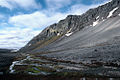 Ymerdalen
 -
 Svalbard Poppy
 -
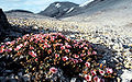 Purple Saxifrage
 -
 old mining ground
 -
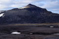 Miseryfjellet from south
 -
 Southern part, seen from Miseryfjellet
 -
Stappen and Sylen


