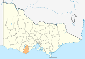
Shire of Colac Otway
Appearance
| Colac Otway Shire Victoria | |||||||||||||||
|---|---|---|---|---|---|---|---|---|---|---|---|---|---|---|---|
 Location in Victoria | |||||||||||||||
| Population | 21,817(2009)[1] | ||||||||||||||
| • Density | 6.3551/km2 (16.4596/sq mi) | ||||||||||||||
| Area | 3,433 km2 (1,325.5 sq mi) | ||||||||||||||
| Mayor | Lyn Russell | ||||||||||||||
| Council seat | Colac | ||||||||||||||
| Website | Colac Otway Shire | ||||||||||||||
| |||||||||||||||
Colac Otway Shire is a Local Government Area in Victoria, Australia. It is located in the south-western part of the state. It includes the towns of Apollo Bay and Colac. It has an area of 3,416 square kilometres. In 2006 it had a population of 20,295. It was formed in 1994 from the merger of the City of Colac, Shire of Colac, Shire of Otway and part of the Shire of Heytesbury.
Wards
- Colac - 3 Councillors
- Murray - 1 Councillor
- Otway - 1 Councillor
- Warrion - 1 Councillor [2]
See also
References
- ^ Australian Bureau of Statistics (30 March 2010). "Regional Population Growth, Australia, 2008–09". Retrieved 3 June 2010.
- ^ Local Government Victoria. "Colac Otway Shire Council". Retrieved 2008-10-30.

