
Puerto Galera
Puerto Galera | |
|---|---|
 Map of Oriental Mindoro showing the location of Puerto Galera | |
| Country | |
| Region | MIMAROPA (Region IV-B) |
| Province | Oriental Mindoro |
| District | 1st District of Oriental Mindoro |
| Founded | — |
| Barangays | 14 |
| Government | |
| • Mayor | Hon. Hubbert Dolor MD. (1st Term) |
| Area | |
| • Total | 247.90 km2 (95.71 sq mi) |
| Population (2000) | |
| • Total | 21,925 |
| • Density | 88/km2 (230/sq mi) |
| Time zone | UTC+8 (PST) |
| Income class | 1st Class; Partially Urban[1] |
Puerto Galera is the northwesternmost municipality in the province of Oriental Mindoro, Philippines. It is located at the southwestern end of the Isla Verde Passage, about 130 kilometers (81 mi) south of Manila.
Demographics
The National Statistical Coordination Board of the Philippines characterizes the municipality of Puerto Galera as 1st Class based on household income.[1] The population was 28,035 at the time of the 2007 Census of Population conducted by the National Statistics Office.[2]
Tourism
This coastal town is well known among tourists for its numerous pocket beaches and many snorkeling and Scuba diving spots. The area was designated a Man and Biosphere Reserve of UNESCO in 1973 and has some of the most diverse coral reef diving in Asia. The marine environment has benefited in recent years from the influx of tourist dollars. This has seen a huge reduction in the number of fishermen in the area, as they gain higher revenue from tourists.
Puerto Galera is a listed by the Club of the Most Beautiful Bays of the World, and is the only bay in the Philippines to be listed there.[3]
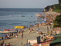
Among the famous beaches in Puerto Galera are Sabang Beach and White Beach, which have an active nightlife with numerous bars and restaurants. Both beaches also have an array of first-class and economy-class accommodations.
Sabang beach is the main destination for foreign tourists, while White Beach remains popular with local travelers.Big La Laguna Beach and Small La Laguna Beach are considered part of Sabang with resorts lining the beaches. Big La Laguna Beach is popular for local swimmers and snorkelers. Since 2001 White beach has seen uncontrolled development. New restaurants and places to stay are rapidly encroaching on the beach itself and little remains of the once charming beach. Puerto Galera town is a pleasant but sleepy Philippine town with few attractions. It has a large central catholic church and a Pier area, with a selection of bistros and cafes.
Behind the beaches are the huge and generally unexplored mountain ranges of central Mindoro. A particular local attraction is the nine hole golf course perched on the hillside above White Beach which commands spectacular views over Puerto Galera's natural harbor and the Verde Island Passage. Mangyan tribes are scattered over the mountain sides - some of the more remote tribes have virtually no contact with the outside world. Of the eight tribes on Mindoro, the Iraya are the largest. They are based in the Puerto Galera area.
Puerto Galera is among the top diving destination in the Philippines. Excellent diving is found less than 5 minutes from Sabang Beach. The diving generally focuses around the areas either side of Escarceo Point, which is famous for its current rips. Strong currents are a feature of the diving in Puerto Galera and it is good advice to employ the services of an experienced local guide or dive centre. There are more than thirty dive sites all within a 5-10 minute banca ride from Sabang Beach. Marine life is highly diverse. 180+ species of nudibranchs are found in the area and many species of fish can be seen. A variety of wrecks have been sunk over the years in addition to the one wreck of an engine of a WWII Japanese patrol boat.
Puerto Galera is also one of the main technical diving destinations in Asia. Technical Diving International - [TDI] has many dive centers in the area, offering the full range of TDI courses from Basic nitrox to advanced trimix.
Environment
In the summer of 1998 there was some extensive coral bleaching around Medio Island and a large section of shallow reef ('Coral Gardens') died. Since then the coral has regrown with a larger diversity of coral species replacing the prolific table corals. Corals in Puerto galera were largely unaffected the 2010 El Nino event.
In 2006 two super-typhoons damaged the shallow areas around Escarceo Point. Many of the faster growing coral species were destroyed to a depth of 6m. This represented about 5% of the coral reef in the area. From mid-2008 there were extensive signs of new coral recruitment. Acropora species (staghorn and table coral) rapidly recolonated the area so that most of the damaged coral have been replaced with new growth.
A study by the University of the Philippines in the 1980s, found that the Batangas, Puerto Galera area has one of the highest diversity of marine species in the world. It forms the centre of the golden triangle - The Philippines, Indonesia and Malaysia - renowned for their coral and fish species.

Barangays
Puerto Galera is politically subdivided into 13 barangays.
- Aninuan
- Balatero
- Dulangan
- Palangan
- Sabang
- San Antonio
- San Isidro
- Santo Niño
- Sinandigan
- Tabinay
- Villaflor
- Poblacion
- Baclayan
Picture gallery
-
 White Beach from the sea
 -
 White Beach, looking towards the west end
 -
 White Beach at sunset, looking towards the northeast end
 -
 La Laguna Beach, 2005


References
- ^ a b Municipality/City: PUERTO GALERA, National Statistics Coordination Board of the Philippines.
- ^ 2000 Census report for Oriental Mindoro - National Statistics Office
- ^ Membership in the France-based Club of the Most Beautiful Bays of the World (Club des Plus Belles Baies du Monde) is obtained by application. The club is chartered to list only one bay per sea in a given country [1]. The club lists the Bay of Puerto Galera (Baie de Puerto Galera) as being located at 13°3' NR, 120°75' in the E China Sea (southern) ("E Mer de Chine (sud)" in French).
External links
- Philippine Standard Geographic Code listing for Puerto Galera - National Statistical Coordination Board
- Puerto Galera at Curlie
- Puerto Galera Wiki Map
- Template:Wikitravel
- Template:Wikitravel
- 505th Squadron Philippine Coast Guard Auxiliary - 505th PCGA, Puerto Galera
Calapan (capital and largest city) | |
| Municipalities | |
| Component city | |