
Washington State Route 520
State Route 520 | ||||
|---|---|---|---|---|
 | ||||
| Route information | ||||
| Auxiliary route of I-5 | ||||
| Maintained by WSDOT | ||||
| Length | 12.82 mi[1] (20.63 km) | |||
| Major junctions | ||||
| West end | ||||
| East end | ||||
| Location | ||||
| Country | United States | |||
| State | Washington | |||
| Highway system | ||||
| ||||

State Route 520 is a state highway and freeway in the U.S. state of Washington. It extends 12.82 miles (20.63 km) from Seattle in the west to Redmond in the east.
Route description
SR-520 originates at Interstate 5 in Seattle at the north end of Capitol Hill just south of Roanoke Park.
It bridges Portage Bay on a viaduct, crosses through the Montlake neighborhood, and continues east on a causeway through the marshlands of the Washington Park Arboretum and across Foster Island. From there it crosses Lake Washington on the Evergreen Point Floating Bridge (1963) to Medina. At 7,578 feet (2,310m), it is the longest floating bridge in the world.
From Medina, it traces the border between Hunts Point and Yarrow Point to the north, and Clyde Hill to the south. Intersecting with Interstate 405 in Bellevue, it then runs into Redmond. It bisects the Microsoft campus, passes Nintendo of America headquarters and crosses the Sammamish River and Bear Creek, before ending at a junction with State Route 202. A set of ramps connecting SR-520 to Avondale Road NE were completed in 1996.
The original name of the freeway in planning documents was the Roanoke Expressway and later the Roanoke Freeway, due to its terminus at Interstate 5 near Roanoke Street and Roanoke Park in Seattle.
Planning history

SR-520 first appears on planning maps in the late 1950s. It is not in the 1956 Comprehensive Plan of Seattle, in which the preferred second bridge crossing of Lake Washington connects Sand Point and Juanita (now part of Kirkland).
In the 1963 and 1967 revisions of the King County Streets and Highways Plan, SR-520 appears in its entirety. The segment from I-5 to I-405 is shown as existing or "to be improved"; the segment from I-405 to SR-202 is shown as "proposed".
The 1967 Puget Sound Regional Council of Governments recommended freeway system omits the segment from I-405 to SR-202, replacing it with a freeway from the Sand Point-Kirkland bridge (then proposed as a third Lake Washington crossing) along the current route of SR-908, deviating southward near West Lake Sammamish Parkway to end at the current SR-520 terminus. In this plan, SR-520 ends at I-405.
All planning maps from 1974 onward show the SR-520 routing as it currently exists.
Construction history
With the completion of the Evergreen Point Floating Bridge in August 1963, SR-520 opened to traffic. Originally, it was legislatively defined as PSH-1 EP (Primary State Highway 1, Evergreen Point branch). The road was signed as PSH-1 without the branch designation.
When the new numbering system for Washington highways took effect in 1964, SR-520 ran from I-5 to the junction of Lake Washington Boulevard NE and Lincoln Avenue (now Bellevue Way).

The segment from I-405 to 148th Avenue NE opened in the early 1970s. In the mid-1970s, the segment between West Lake Sammamish Parkway and SR-202 opened with the route number State Route 920 as a Super-2 freeway. This segment was widened to a divided 4-lane freeway by 1990.
The final segment of SR-520 between 148th Avenue NE and West Lake Sammamish Parkway opened circa 1979. At this time, SR-920 was redesignated as SR-520.
In 1973, the right-side shoulder of westbound SR-520 from Bellevue Way to the Evergreen Point Floating Bridge was converted for use as a transit-only lane, so that buses could bypass the tollbooths for the bridge. The existing general-purpose lanes were narrowed to accommodate the conversion. In the late 1980s, the lane was redesignated as a HOV lane for carpools of 3 or more, in addition to transit use.
In the 1990s, both sides of SR-520 from the I-405 interchange to W Lake Sammamish Parkway were widened to add a HOV lane on both sides, and collector-distributor lanes were added from NE 40th Street to W Lake Sammamish Parkway. A new interchange was built at NE 40th Street to accommodate expansion of the Microsoft and Nintendo of America corporate campuses.
State Route 920
State Route 920 was a temporary designation of what is now part of State Route 520 between West Lake Sammamish Parkway - known at the time as State Route 901, and State Route 202 in Redmond. The original roadway was a 4 lane undivided link road between the two highways. SR 520 had only been completed to 148th Ave NE when SR 920 was constructed. When the missing link between 148th Ave NE and SR 901 was completed in the early 1980s, SR 920 was replaced by the SR 520 designation. However upon completion, there was a short section crossing SR 901 where SR 520 narrowed to one lane, and then immediately back to two. This section of SR 520 was widened and a new interchange was built at the junction of SR 520, SR 202, and Avondale Road - the former eastern terminus of SR 920.[2]
Ongoing improvements
Because of massive residential, commercial, and industrial growth in the Eastside over the past 15 years, several projects have been proposed to improve the entire stretch of State Route 520.
- Replacement of the Evergreen Point Floating Bridge and freeway expansion to 6 lanes (2 general-purpose/1 HOV per side) between Interstate 5 and Interstate 405. On April 17, 2009, the House granted the WSDOT authority to impose a toll on the existing bridge to generate funding for its replacement.[3] As of August 2011, the toll has yet to be activated due to technical difficulties with the toll collection equipment.[4]
- Freeway expansion to 8 lanes (2 general-purpose/1 HOV/1 auxiliary lane per side) between West Lake Sammamish Parkway and State Route 202, along with widening existing ramps between SR-202 and Avondale Road to 2 lanes.)
- Eastbound collector-distributor lanes between Interstate 405 and 124th Avenue NE as part of I-405 braided-ramp improvements between NE 8th Street and SR-520 in Bellevue.
Proposed improvements
- A flyover ramp from westbound SR-520 to southbound Interstate 405 is currently deferred due to lack of construction funds.
- The Sound Transit 2 proposal would add a Bus Rapid Transit (BRT) line to the entire SR-520 corridor, and a light rail extension joining the corridor in the vicinity of Overlake, continuing to the Overlake Transit Center on the Microsoft campus.
Completed improvements
- The flyover ramp from westbound State Route 202 to SR-520 opened in Spring 2008.
- SR-520 between Bellevue Way and the Evergreen Point Floating Bridge was paved with several types of quiet asphalt pavement as a test bed in Fall 2007.
- Ramps connecting the end of SR-520 from SR-202 to Avondale Road were completed in 1996.
- And overpass was constructed connecting NE 36th Street and NE 31st Street on the Microsoft campus. The bridge was completed in December 2010. Microsoft provided almost half of the funding for this bridge.[5]
Ghost ramps

SR 520 features a set of ghost ramps in the marshlands of Washington Park Arboretum. They are often referred to as "ramps to nowhere". However, there are 2 ramps currently used for the Westbound 520 off ramp connection to the Washington Park Arboretum while the other serves as an on ramp only to SR 520 Eastbound. The others are unused. They were originally part of a plan to build the R. H. Thomson Expressway which would have cut through the arboretum and down through Seattle towards the I-90/I-5 interchange. Citizens rallied a freeway revolt against the plan on May 4, 1969. Construction near the Arboretum later continued but citizen protest eventually won out and the plan was dropped in 1971.
The freeway revolt that stopped the R. H. Thomson Expressway had its origins in opposition to SR 520 itself. Architect Victor Steinbrueck, writing in 1962, objected to the "naked brutality of unimaginative structures such as this proposed crossing of Portage Bay, which eliminates fifty houseboats while casting its shadow and noise across this tranquil boat haven."[6]
Exit list
The entire route is in King County.
| Location | Mile | Destinations | Notes |
|---|---|---|---|
| Seattle | 0.00 | Westbound exit and eastbound entrance | |
| 0.19 | Roanoke Street, Harvard Avenue | Westbound exit only | |
| 0.94 | Montlake Boulevard (SR 513) – University of Washington | ||
| 1.31 | Lake Washington Boulevard | Westbound exit and eastbound entrance | |
| 3.07 | Evergreen Point Floating Bridge over Lake Washington | ||
| Medina | |||
| Hunts Point | 4.59 | 84th Avenue Northeast | Eastbound exit and westbound entrance |
| Yarrow Point, Clyde Hill |
5.17 | 92nd Avenue Northeast | Westbound exit and eastbound entrance |
| Bellevue | 5.97 | Bellevue Way Northeast, Lake Washington Boulevard Northeast | Eastbound exit and westbound entrance; former SR 908 |
| 6.27 | 108th Avenue Northeast | No eastbound exit | |
| 6.93 | |||
| 7.52 | 124th Avenue Northeast | Eastbound exit and westbound entrance | |
| 9.17 | 148th Avenue Northeast | ||
| Redmond | |||
| 10.13 | Northeast 40th Street | The Northeast 40th Street interchange was not part of the original SR-520 plan but was constructed circa 1998. | |
| 10.73 | Northeast 51st Street | Completed in 1986. | |
| 11.79 | West Lake Sammamish Parkway Northeast | Former SR 901 | |
| 12.73 | |||
| 12.82 | Avondale Road | Continuation beyond SR 202 | |
Gallery
-
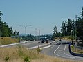 SR 520 looking south from the N.E. 51st Street overpass. Mount Rainier is in the background.
 -


Related routes
References
- ^ Washington State Department of Transportation. "State Highway Log, 2006" (PDF). Retrieved 2007-04-22.
- ^ WSDOT: SR 520 - West Lake Sammamish Parkway to State Route 202
- ^ http://blog.seattlepi.com/seattlepolitics/archives/166795.asp
- ^ Lindblom, Mike (June 10, 2011). "Drivers' glee aside, delay in 520 bridge toll costs state". Retrieved 2011-08-95.
{{cite news}}: Check date values in:|accessdate=(help); Unknown parameter|pub=ignored (|publisher=suggested) (help) - ^ http://www.redmond.gov/cms/One.aspx?portalId=169&pageId=1381
- ^ Victor Steinbrueck, Seattle Cityscape, University of Washington Press, Seattle, 1962, p. 132.