Manzanita, Oregon
Manzanita, Oregon | |
|---|---|
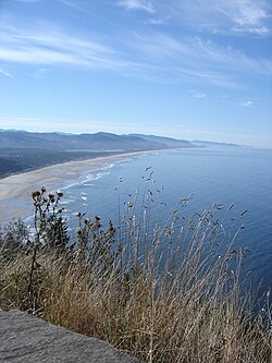
 Manzanita Beach from Highway 101, due north of the town. | |
 Location in Oregon | |
| Country | United States |
| State | Oregon |
| County | Tillamook |
| Incorporated | 1946 |
| Government | |
| • Mayor | Garry Bullard |
| Area | |
| • Total | 0.7 sq mi (1.9 km2) |
| • Land | 0.7 sq mi (1.9 km2) |
| • Water | 0 sq mi (0 km2) |
| Elevation | 78 ft (23.8 m) |
| Population (2000) | |
| • Total | 564 |
| • Density | 759.1/sq mi (294.3/km2) |
| Time zone | UTC-8 (Pacific) |
| • Summer (DST) | UTC-7 (Pacific) |
| ZIP code | 97130 |
| Area code | 503 |
| FIPS code | 41-45700Template:GR |
| GNIS feature ID | 1123738Template:GR |
| Website | www.ci.manzanita.or.us |
Manzanita (/[invalid input: 'icon']ˌmænzəˈniːtə/) is a coastal city in Tillamook County, Oregon, United States. It is located on U.S. Route 101 about 25 miles south of Seaside and 25 miles north of Tillamook. The population was 564 as of the 2000 census.
History
Manzanita was platted as a beach resort in 1912.[1] Manzanita post office was established in 1914 and named for the manzanita (Arctostaphylos tomentosa) that grows in the area.[1] Manzanita means "little apple" in Spanish.[1]
Geography
According to the United States Census Bureau, the city has a total area of 0.7 square miles (1.8 km2), all of it land.Template:GR
Demographics
As of the censusTemplate:GR of 2000, there were 564 people, 307 households, and 177 families residing in the city. The population density was 759.1 people per square mile (294.3/km²). There were 1,078 housing units at an average density of 1,450.9 per square mile (562.5/km²). The racial makeup of the city was 96.45% White, 0.53% Native American, 0.89% from other races, and 2.13% from two or more races. Hispanic or Latino of any race were 1.60% of the population.
There were 307 households out of which 9.4% had children under the age of 18 living with them, 51.1% were married couples living together, 4.6% had a female householder with no husband present, and 42.3% were non-families. 38.8% of all households were made up of individuals and 18.6% had someone living alone who was 65 years of age or older. The average household size was 1.84 and the average family size was 2.33.
In the city the population was spread out with 10.8% under the age of 18, 4.3% from 18 to 24, 14.4% from 25 to 44, 36.0% from 45 to 64, and 34.6% who were 65 years of age or older. The median age was 57 years. For every 100 females there were 84.9 males. For every 100 females age 18 and over, there were 83.6 males.
The median income for a household in the city was $38,750, and the median income for a family was $43,958. Males had a median income of $30,000 versus $25,833 for females. The per capita income for the city was $26,428. About 4.9% of families and 7.2% of the population were below the poverty line, including 22.4% of those under age 18 and 4.7% of those age 65 or over.

Points of interest
Transportation
References
- ^ a b c McArthur, Lewis A.; McArthur, Lewis L. (2003) [1928]. Oregon Geographic Names (7th ed.). Portland, Oregon: Oregon Historical Society Press. p. 608. ISBN 978-0875952772.

