
1959 Atlantic hurricane season
| 1959 Atlantic hurricane season | |
|---|---|
 Season summary map | |
| Seasonal boundaries | |
| First system formed | May 28, 1959 |
| Last system dissipated | October 21, 1959 |
| Strongest storm | |
| Name | Gracie |
| • Maximum winds | 140 mph (220 km/h) |
| • Lowest pressure | 940 mbar (hPa; 27.76 inHg) |
| Seasonal statistics | |
| Total depressions | 11 |
| Total storms | 11 |
| Hurricanes | 7 |
| Major hurricanes (Cat. 3+) | 2 |
| Total fatalities | 58 direct, 1 indirect |
| Total damage | At least $23.3 million (1959 USD) |
The 1959 Atlantic hurricane season officially began on June 15, 1959, and lasted until November 15, 1959.[1] These dates conventionally delimit the period of each year when most tropical cyclones form in the Atlantic basin. The season began on May 28, before the official bounds, and had an unusual number of early-forming storms.
The most notable storm of 1959 was Hurricane Gracie, which caused ten deaths when it made landfall near Beaufort, South Carolina as well as millions in damage; another eleven were killed by a tornado generated as Gracie weakened. Another notable storm was the Escuminac Hurricane, or Hurricane #3, which hit Escuminac, New Brunswick on June 19 as a hurricane, sinking 22 boats and killing 35 men.
Season summary
The season's activity was reflected with a cumulative accumulated cyclone energy (ACE) rating of 77.[2] ACE is, broadly speaking, a measure of the power of the hurricane multiplied by the length of time it existed, so storms that last a long time, as well as particularly strong hurricanes, have high ACEs. ACE is only calculated for full advisories on tropical systems at or exceeding 34 knots (39 mph, 63 km/h) or tropical storm strength. Subtropical storms are not included in the ACE value.[3]
Storms
Tropical Storm Arlene
| Tropical storm (SSHWS) | |
  | |
| Duration | May 28 – June 2 |
|---|---|
| Peak intensity | 60 mph (95 km/h) (1-min); 1000 mbar (hPa) |
A tropical wave moving through the Caribbean Sea and the Gulf of Mexico developed into a tropical depression on May 28. Conditions were generally favorable, despite being outside of the official season, and it strengthened into a tropical storm the next day. Arlene reached its peak of 60 mph (95 km/h) before unfavorable conditions weakened it to a minimal tropical storm at its Louisiana landfall on May 30. It moved northeastward and dissipated on June 2 after causing $500,000 in damage (1959 USD) and one death.
Tropical Storm Beulah
| Tropical storm (SSHWS) | |
 | |
| Duration | June 15 – June 18 |
|---|---|
| Peak intensity | 70 mph (110 km/h) (1-min); 987 mbar (hPa) |
The precursor to Tropical Storm Beulah was a cold front that stalled in the Bay of Campeche on June 15. It drifted northwestward, becoming a tropical storm the next day. As it neared the Mexican coastline, a building ridge of high pressure to its north pushed Beulah southward, where upper level winds caused it to dissipate on June 18.
Hurricane Three
| Category 1 hurricane (SSHWS) | |
  | |
| Duration | June 18 – June 21 |
|---|---|
| Peak intensity | 80 mph (130 km/h) (1-min); 974 mbar (hPa) |
On June 18, a rapidly northeastward moving tropical wave near a cold front developed into a tropical depression. It crossed Florida, bringing heavy rain and severe weather across the state. Later that day, it became a tropical storm, and it became a hurricane the next day as it raced into the north Atlantic. It became extratropical late on the June 19, and hit near Escuminac, New Brunswick, on the night of June 19 and June 20, where it caused massive damage to the fishing community.
The hurricane caused 33 deaths and considerable damage as an extratropical cyclone. It also caused $1,656,000 (1959 USD) in damage in Florida, most of which came from a single tornado in Miami.
Hurricane Cindy
| Category 1 hurricane (SSHWS) | |
  | |
| Duration | July 5 – July 12 |
|---|---|
| Peak intensity | 75 mph (120 km/h) (1-min); 996 mbar (hPa) |
A trough of low pressure from a frontal boundary developed into a tropical depression on July 5 off the coast of Florida. It moved northeastward, where it became a tropical storm on the July 7 A small hurricane, Cindy drifted to the west, and hit north of Charleston, South Carolina on July 9 as a minimal hurricane. It turned northeast, and weakened to a tropical depression. As it sped by the mouth of the Chesapeake Bay, the instability of the atmosphere allowed Cindy to restrengthen to a tropical storm. It continued northeastward, and became extratropical on July 11, after causing one death.
Hurricane Debra
| Category 1 hurricane (SSHWS) | |
  | |
| Duration | July 23 – July 28 |
|---|---|
| Peak intensity | 85 mph (140 km/h) (1-min); 984 mbar (hPa) |
The development of Hurricane Debra can be attributed to a cold core upper level low. It developed thunderstorm activity over the Bahamas, and as it drifted westward, it steadily organized into a tropical depression on July 23. It continued slowly westward, and became a tropical storm later that day. Debra turned northward due to the subtropical ridge, and hit between Freeport, Texas and Galveston, Texas on July 25 as a minimal hurricane. It weakened over Texas, and dissipated over western Oklahoma. Debra caused a total of $7 million (1959 dollars) in damage, but no fatalities.
Tropical Storm Edith
| Tropical storm (SSHWS) | |
 | |
| Duration | August 17 – August 19 |
|---|---|
| Peak intensity | 60 mph (95 km/h) (1-min); 1007 mbar (hPa) |
Tropical Storm Edith developed from a tropical wave on August 17, east of the Lesser Antilles. It became a tropical storm the next day, and reached a peak of 60 mph (95 km/h) winds as it moved through the islands. Its rapid movement contributed to its demise, however, and upper level winds weakened it until dissipation on the August 19 while south of the Dominican Republic.
Hurricane Flora
| Category 1 hurricane (SSHWS) | |
 | |
| Duration | September 9 – September 14 |
|---|---|
| Peak intensity | 75 mph (120 km/h) (1-min); 994 mbar (hPa) |
The combination of a trough of low pressure and a tropical wave developed into a tropical depression on September 9 in the tropical Atlantic. It turned northeastward and became a tropical storm on the September 10 and a hurricane on September 11. As Flora accelerated over the northern Atlantic, it lost its tropical characteristics on the September 12, remaining a powerful extratropical cyclone over the next two days.
Hurricane Gracie
| Category 4 hurricane (SSHWS) | |
  | |
| Duration | September 20 – October 2 |
|---|---|
| Peak intensity | 140 mph (220 km/h) (1-min); 950 mbar (hPa) |
Hurricane Gracie had an unusual track, constantly switching directions as it headed towards South Carolina. It hit the state as a 120 mph (200 km/h) major hurricane on September 29, and caused tornadoes across the Southeast United States. Gracie caused a total of 22 casualties and $14 million (1959 USD) in damage, much of which came from tornadoes.
Hurricane Hannah
| Category 3 hurricane (SSHWS) | |
 | |
| Duration | September 27 – October 8 |
|---|---|
| Peak intensity | 125 mph (205 km/h) (1-min); 959 mbar (hPa) |
An upper level trough over the central Atlantic caused the development of a tropical depression on September 27. It rapidly strengthened the next day, reaching hurricane strength on the night of September 28. It reached a peak of 125 mph on October 1, but was only a threat to shipping. After turning to the east, it remained a hurricane until October 8, where it became extratropical south of Iceland.
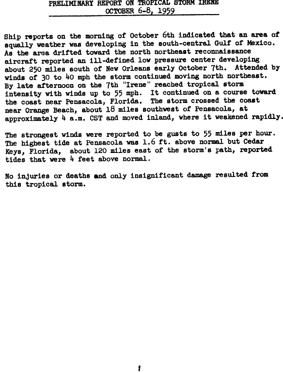
Tropical Storm Irene
| Tropical storm (SSHWS) | |
  | |
| Duration | October 6 – October 9 |
|---|---|
| Peak intensity | 60 mph (95 km/h) (1-min); 1001 mbar (hPa) |
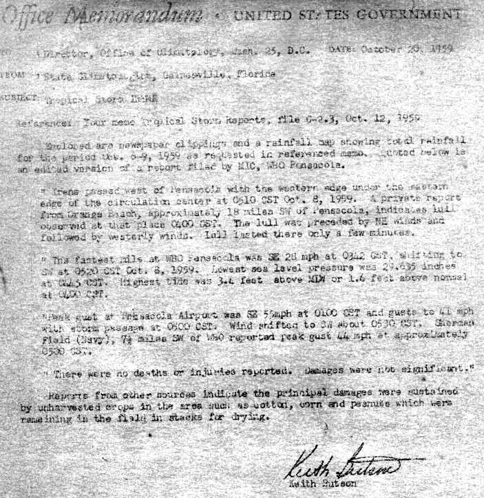
Irene originated from a shortwave aloft over the Midwestern United States that drifted through Texas, accompanied an associated cold front on October 4. The system progressed into the Gulf of Mexico on October 5 as the front dissipated, though a related trough remained. Upper-level air temperatures were generally warm, while a minimal anticyclone–a large mass of air rotating clockwise–was situated over the Gulf.[4] At this time, a Colorado low (a low-pressure system that frequently forms over Colorado and New Mexico) drew polar air into the Mississippi Valley.[5] The system attained tropical depression status on October 6;[6] it meandered in a north-northeasterly direction for the two days that followed.[4] The storm intensified to reach tropical storm status near 1800 UTC on October 7 and was named "Irene" while it began to turn northward. This made Irene the tenth tropical storm of the season.[6] At this point, a trip into the storm indicated that the low's center was indistinct though it was continuing to evolve at the time of the flight.[7] By October 8, a second reconnaissance aircraft traveled into Irene recorded a minimum atmospheric pressure of 1001 mbar (hPa; 29.56 inHg), and the storm came ashore near Pensacola, Florida late during the day as a well-organized tropical storm. Irene rapidly weakened into a tropical depression as it moved inland, dissipating early on October 9.[4][6] Study of the storm afterwards indicated that the system could have been of extratropical origin rather than of full tropical origin. Although polar air was situated over the area, Irene's precipitation fell as rain.[5]
The highest tides, 4.4 feet (1.3 m) above normal, were reported at the Cedar Keys in Florida, while the strongest gust recorded, 48 knots, was measured at Pensacola International Airport.[4] Heavy rainfall from Irene was widespread; the highest total in Florida was 7.69 inches (195 mm) at Tyndall Air Force Base,[8] although the highest overall total from the storm was inland in Georgia at Neels Gap. Rainfall also occurred in the Carolinas, Tennessee,[9] Mississippi, Alabama, and Louisiana.[10] Flooding from Irene's torrential rains caused damage around the Lake Okeechobee area.[5] General damage in the state was limited to uncollected crops, mainly peanuts and corn; many of these were in bales that were in the process of being dried.[11] Along the coast at Shalimar, Florida near Ft. Walton Beach, yards were flooded. A short power outage occurred in Ocean City, Florida, and was accompanied by downed tree limbs, in addition to a sign and telephone pole that were blown down.[12] At time of Irene's arrival, red tides were ongoing in western Florida; winds from the storm's precursor blew thousands of dead fish ashore. Local residents complained that the odor from the rotting fish were unbearable.[13] No deaths or injuries were reported as a result of Irene, and damage was minimal.[4]
Hurricane Judith
| Category 1 hurricane (SSHWS) | |
  | |
| Duration | October 17 – October 21 |
|---|---|
| Peak intensity | 80 mph (130 km/h) (1-min); 999 mbar (hPa) |
A disturbance moved along the Intertropical Convergence Zone through the Caribbean Sea, producing squally weather. A low formed south of Jamaica on October 15. Soon after merging with another low moving eastward from the southern Gulf of Mexico, the combined system developed into a tropical storm in the southeast Gulf of Mexico on October 17.[14] Judith moved over Florida the next day after reaching hurricane strength, and moved rapidly out to sea, reaching a peak of 80 mph (130 km/h), but steadily weakened until dissipating on the October 21 east of Bermuda.
Records
The season set records for the earliest formation of its fourth and fifth storms. Hurricane Cindy was named on July 7, and Hurricane Debra first reached tropical storm strength on July 23, following the development of Tropical Storm Arlene, Tropical Storm Beulah and Hurricane #3. Both of these records were broken in the 2005 season when Dennis formed on July 5 and Emily formed on July 11.
Storm names
The following names were used for named storms (tropical storms and hurricanes) that formed in the North Atlantic in 1959. All names in this list were first time in 1959.
|
|
|
Retirement
Gracie would later be retired, though it is unclear if the name was retired or not.
See also
References
- ^ Associated Press. Hurricane Season Almost Here, Will Open at Midnight Tonight. Retrieved on 2008-06-06.
- ^ Hurricane Research Division (March 2011). "Atlantic basin Comparison of Original and Revised HURDAT". National Oceanic and Atmospheric Administration. Retrieved 2011-07-23.
- ^ David Levinson (2008-08-20). "2005 Atlantic Ocean Tropical Cyclones". National Climatic Data Center. Retrieved 2011-07-23.
- ^ a b c d e Template:Cite doi/10.1175/1520-0493-87.12.441
- ^ a b c Gelhard, Robert H. (October 1959). "The Weather and Circulation of October 1959" (PDF). Monthly Weather Review. 87 (10). Washington, D.C.: American Meteorological Society: 392, 394. doi:10.1175/1520-0493(1959)087<0388:TWACOO>2.0.CO;2. ISSN 1520-0493.
{{cite journal}}: Check date values in:|date=(help) - ^ a b c Hurricane Specialists Unit (August 2011). "Easy to Read HURDAT 2011". Hurricane Research Division. National Oceanic and Atmospheric Administration. Retrieved 2011-12-27.
{{cite web}}: Check date values in:|date=(help) - ^ "Tropical Storm Irene – October 6–8, 1959". United States Department of Commerce. Washington, D.C.: Weather Bureau. October 1959. Retrieved 2011-12-29.
{{cite web}}: Check date values in:|date=(help) - ^ Roth, David M. (2010-11-22). "Tropical Cyclone Rainfall in Florida". Tropical cyclone rainfall data. Camp Springs, Maryland: Hydrometeorological Prediction Center. Retrieved 2011-12-29.
- ^ Roth, David M. (2011-02-14). "Tropical cyclone rainfall in the Southeast". Tropical cyclone rainfall data. Camp Springs, Maryland: Hydrometeorological Prediction Center. Retrieved 2011-12-29.
- ^ Roth, David M. (2011-09-21). "Tropical Cyclone Rainfall for the Gulf Coast". Tropical cyclone rainfall data. Camp Springs, Maryland: Hydrometeorological Prediction Center. Retrieved 2011-12-29.
- ^ Butson, Keith (1959-10-20). "Office Memorandum – Tropical Storm Irene". State Climatologist's Office. Gainesville, Florida: Weather Bureau. Retrieved 2011-12-29.
- ^ Staff writer (1959-10-08). "Florida Resort Area Is Lashed By Storm Irene". Meriden Journal. Pensacola, Florida. Associated Press. Retrieved 2011-12-29.
- ^ Staff writer (1959-10-08). "Beaches May Get More Dead Fish". Daytona Beach Morning Journal. St. Petersburg, Florida. Associated Press. Retrieved 2011-12-29.
- ^ http://www.aoml.noaa.gov/general/lib/lib1/nhclib/mwreviews/1959.pdf
External links
Tropical cyclones of the 1959 Atlantic hurricane season | ||
|---|---|---|
 | ||