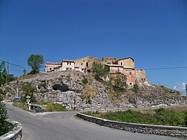
Ongles
Appearance
You can help expand this article with text translated from the corresponding article in French. (December 2008) Click [show] for important translation instructions.
|
Ongles | |
|---|---|
 Rocher d'Ongle hamlet | |
| Country | France |
| Region | Provence-Alpes-Côte d'Azur |
| Department | Alpes-de-Haute-Provence |
| Arrondissement | Forcalquier |
| Canton | Saint-Étienne-les-Orgues |
| Intercommunality | Pays de Forcalquier et Montagne de Lure |
| Government | |
| • Mayor (2008–2014) | Robert Pecoul |
| Area 1 | 31.46 km2 (12.15 sq mi) |
| Population (2008) | 331 |
| • Density | 11/km2 (27/sq mi) |
| Time zone | UTC+01:00 (CET) |
| • Summer (DST) | UTC+02:00 (CEST) |
| INSEE/Postal code | 04141 /04230 |
| Elevation | 517–1,320 m (1,696–4,331 ft) |
| 1 French Land Register data, which excludes lakes, ponds, glaciers > 1 km2 (0.386 sq mi or 247 acres) and river estuaries. | |
Ongles is a commune in the Alpes-de-Haute-Provence department in southeastern France.
Population
| Year | 1765 | 1793 | 1800 | 1806 | 1821 | 1831 | 1836 | 1841 | 1846 | 1851 |
|---|---|---|---|---|---|---|---|---|---|---|
| Population | 709 | 667 | 619 | 669 | 730 | 827 | 801 | 834 | 828 | 759 |
| Year | 1856 | 1861 | 1866 | 1872 | 1876 | 1881 | 1886 | 1891 | 1896 | 1901 |
|---|---|---|---|---|---|---|---|---|---|---|
| Population | 734 | 701 | 704 | 670 | 681 | 681 | 696 | 623 | 616 | 607 |
| Year | 1906 | 1911 | 1921 | 1926 | 1931 | 1936 | 1946 | 1954 | 1962 | 1968 |
|---|---|---|---|---|---|---|---|---|---|---|
| Population | 538 | 501 | 418 | 386 | 367 | 370 | 320 | 282 | 237 | 240 |
| Year | 1975 | 1982 | 1990 | 1999 | 2008 |
|---|---|---|---|---|---|
| Population | 187 | 197 | 239 | 278 | 331 |
See also
References


