
Okinawa Island
This article needs additional citations for verification. (January 2012) |
 | |
| Geography | |
|---|---|
| Location | Pacific Ocean |
| Coordinates | 26°30′N 127°56′E / 26.500°N 127.933°E |
| Archipelago | Okinawa Islands |
| Area | 1,201.03 km2 (463.72 sq mi) |
| Administration | |
Japan | |
| Demographics | |
| Population | 1,384,762 |
| Pop. density | 1,015.79/km2 (2630.88/sq mi) |
Okinawa Island (沖縄本島, Okinawa-hontō, alternatively 沖縄島 Okinawa-jima; Okinawan: ウチナー Uchinaa; Nakijin: フチナー Fuchinaa) is the largest of the Okinawa Islands and the Ryukyu (Nansei) Islands of Japan, and is home to Naha, the capital of Okinawa Prefecture. The island has an area of 1,201.03 square kilometers (463.72 sq mi). It is roughly 640 kilometres (400 mi) south of the rest of Japan.
History
The island of Okinawa was the site of most of the ground warfare in the Battle of Okinawa during World War II, when American Army and Marine Corps troops fought a long and bloody battle to capture Okinawa, so it could next be used as the major air force and troop base for the planned invasion of Japan. During this 82-day-long battle, about 95,000 Imperial Japanese Army troops and 12,510 Americans were killed, and in addition to these deaths, somewhere between 42,000 and 150,000 Okinawan civilians - approximately one quarter of the civilian population - were also killed.
During the American military occupation of Japan (1945–52), which followed the Imperial Japanese surrender on September 2, 1945, in Tokyo Bay, the United States controlled Okinawa Island and the nearby Ryukyu islands and islets. These all remained in American military possession until June 17, 1972, with numerous U.S. Army, U.S. Marine Corps, and U.S. Air Force bases there.
Since 1972, United States Armed Forces personnel have remained on Okinawa Island by the invitation of the Government of Japan as a measure partially fulfilling the Treaty of Mutual Cooperation and Security between the United States and Japan.
There has been a movement among some of the local Japanese Okinawan population against the American military and naval presence on Okinawa, especially after several rape cases that were prosecuted against American servicemen. The most publicized rape took place on September 4, 1995, when three American servicemen from Camp Hansen, kidnapped and raped a 12-year-old 6th-grade Japanese girl. All three were arrested, tried, convicted, and imprisoned for this crime.
In February 2010 an earthquake, measuring 7.0 on the Richter Scale, hit the island.
Demographics
As of September, 2009, the Japanese government estimates the population at 1,384,762,[1] which includes American military personnel and their families. The Okinawan language is called Uchinaguchi or "Hogen" and is spoken mostly by the elderly people[2]. Okinawan people speak Japanese since the Ryukyu Kingdom joined Japan.[citation needed]
Whereas northern Okinawa Island is largely unpopulated, the south is markedly urbanized—particularly the city of Naha, and the urban corridor stretching north from there to the city of Okinawa.
There are six gusuku, medieval Okinawan fortresses, most of which now lie in ruins.[3]
The southern part of the island has an American presence which creates a cultural blend. In the north, American presence is less concentrated, although several smaller bases and recreation facilities are there.[citation needed]
Geography
Okinawa is the fifth largest island in the Japan (excluding the disputed islands north of Hokkaido). The island has an area of 1,201.03 square kilometers (463.72 sq mi). It is roughly 640 kilometres (400 mi) south of the rest of Japan.
Geology
The southern end of the island consists of uplifted coral reef, whereas the northern half has proportionally more igneous rock. The easily eroded limestone of the south has many caves, the most famous of which is Gyokusendō in Nanjō. An 850 m stretch is open to tourists.
Fauna
In the forests of Yanbaru there are a small number of Yanbaru Kuina, a small flightless bird that is near extinction.
The Indian mongoose was introduced to the island to prevent the native Habu pit viper from attacking the birds. It did not succeed in eliminating the Habu, but instead preyed on birds.
Climate
The island's subtropical climate supports a dense northern forest and a rainy season occurring in late spring.

Culture
There are many local izakaya and cafes that cater to specific Okinawan cuisines such as goya champuru (bitter melon), fu champuru (wheat gluten), and tonkatsu (tenderized, breaded, fried pork cutlet). Okinawan soba is the signature dish as opposed to the mainland version (buckwheat noodles served cold with soy sauce). Okinawan soba are noodles served hot in a soup usually with pork (rib or pork belly.) American presence on the island has also created some creative dishes such a taco rice, which is now a common meal served in bentos.
Economy
Tourism
The north has more of a agricultural, traditional type lifestyle. The North has a number of tourist attractions in Nago. There are two festivals annually.[4][5] Other tourist attractions include a beach, a park and a beer factory.[6] and Hiji Falls. There are scenic routes in the north.
US Military
There are 32[7] US Military bases of the United States Air Force, Navy, Army, and Marines. These bases include Futenma,[8] Kadena, Hansen, Torii, Schwab, Foster, and Kinser.[citation needed] And they account for 4 to 5% of the economy nowadays.[9] In 2012, an agreement was struck between the United States and Japan to reduce the number of US military personnel on the island moving 9000 personnel to other locations, but 10 000 marines will remain on the island, on top of other US military units.[10][8]
Transportation
Naha Airport serves the island.
Film
Okinawa was also the setting for the 1986 film The Karate Kid, Part II where Mr Miyagi (Pat Morita) returns home to Okinawa with his student Daniel LaRusso (Ralph Macchio). Although Okinawa was the setting for the film, only short scenes of the film were actually filmed in Okinawa. Teahouse of the August Moon, starring Marlon Brando and based on the play, was also filmed on location in Okinawa.
See also
Photo gallery
-
 Cliffs at Manzamo
 -
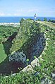 Gusuku wall
 -
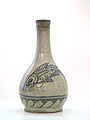 Okinawa Island is the home of Tsuboya-yaki, pottery in the Ryūkyūan tradition.
 -
 Okinawa Island from Space Shuttle Mission STS-43 (Earth Sciences and Image Analysis, NASA-Johnson Space Center)
 -
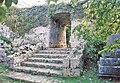 Gusuku Ruins
 -
 Bullfighting arena. Okinawa is the home of a form of bullfighting sometimes compared to sumo
 -
 Traditional Okinawan house
 -
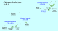 Map of Okinawa Prefecture showing location of Okinawa Island
 -
 Village of Onna
 -
 Pond
Pond -
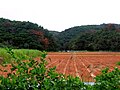 Farmland on Okinawa Island
 -
 A beach on Okinawa


References
- ^ http://www.pref.okinawa.jp/toukeika/estimates/estidata.html
- ^ Ethnologue: Languages of the World (unknown ed.). SIL International.[This citation is dated, and should be substituted with a specific edition of Ethnologue]
- ^ "Gusuku Sites and Related Properties of the Kingdom of Ryukyu." UNESCO: World Heritage Convention.
- ^ Orion Beer Festival and the Cherry Tree Blossom Festival
- ^ Sakura Matsuri
- ^ Century Beach, Pineapple Park and Orion Beer Factory
- ^ http://www.japantimes.co.jp/text/fl20120513x1.html
- ^ a b Jaffe, Greg; Heil, Emily; Harlan, Chico (April 26, 2012), "U.S. comes to agreement with Japan to move 9,000 Marines off Okinawa", The Washington Post, washingtonpost.com, retrieved April 28, 2012
- ^ http://www.japantimes.co.jp/text/nn20120516f2.html
- ^ http://www.japantimes.co.jp/text/nn20120428a2.html