Tiszagyenda
Appearance
Tiszagyenda | |
|---|---|
| Country | |
| County | Jász-Nagykun-Szolnok |
| Area | |
| • Total | 36.93 km2 (14.26 sq mi) |
| Population (2001) | |
| • Total | 1,077 |
| • Density | 29/km2 (80/sq mi) |
| Time zone | UTC+1 (CET) |
| • Summer (DST) | UTC+2 (CEST) |
| Postal code | 5233 |
| Area code | 56 |

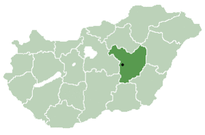
Tiszagyenda is a village in Jász-Nagykun-Szolnok county, in the Northern Great Plain region of central Hungary.
Geography
It covers an area of 36.93 km2 (14 sq mi) and has a population of 1077 people (2001).

Maps
47°23′N 20°31′E / 47.383°N 20.517°E


