
Zennor Head
| Zennor Head | |
|---|---|
 Zennor Head, looking north | |
 | |
| Type | Promontory |
| Location | Cornwall |
| Nearest city | Zennor |
| Coordinates | 50°11′53″N 5°34′26″W / 50.198°N 5.574°W |
| Etymology | Saint Senara |
| Operated by | National Trust |
Zennor Head /ˈzɛnʊər hɛd/ is a 750 metre (2,460 ft) long promontory on the Cornish coast of England, between Pendour Cove and Porthzennor Cove. Facing the Atlantic Ocean, it lies 1 kilometre north-west of the village of Zennor and 1.6 kilometres east of the next promontory, Gurnard's Head. The granite (Killas) cliffs rise over 200 feet (60 m) from the sea and the highest point of the headland is 314 feet (96 m) above sea level, with an Ordnance Survey triangulation station. Zennor Head is on the South West Coast Path, which follows the cliff edge closely, skirting the entire perimeter of the headland. The promontory is part of the Penwith Heritage Coast, and is the largest coastal feature in the United Kingdom that begins with the letter "Z". It gets its name from a local saint, Senara. Zennor Head was mined for copper and tin in the Victorian Era, and an abandoned mine was used as the target for a World War II training exercise, Exercise Brandyball. There is no longer any residential or commercial occupancy on the headland, but it is occupied by a variety of coastal animals and plants, such as kestrels and gorse.
Etymology
The name "Zennor Head" originates from the name of a local saint, Senara. According to local legend, Senara was thrown off a headland in Brittany in a barrel after being falsely accused of adultery by her husband and washed up on the Cornish coast, founding Zennor and giving her name to the eponymous village (and subsequently Zennor Head, Zennor Quoit and Porthzennor Cove), before continuing to Ireland.[1][2] The "s" changed to a "z", an occurrence common in the West Country but rare elsewhere, and as such is the largest coastal feature in the United Kingdom to begin with the letter "Z".[1]
History

The headland is bordered by Cornish granite hedges, and the farming system dates from about 4000 BC, the time of the Bronze Age in Cornwall.[2] The surrounding area and village of Zennor has been continually occupied for over 4,000 years.[3] Zennor Head was mined extensively for copper and tin in the 19th century, and drainage adits remain visible on the eastern side.[3]
In 1943, the middle of World War II, No. 4 British Commando were involved in a mock seaborne raid codenamed "Exercise Brandyball", which took place on the 300-foot (90 m) cliffs of Zennor Head known as the 'Brandys'.[4] The training exercise was deemed one of the most hazardous and challenging of the war,[5] beginning with a seaborne landing,[4] followed by a climb up the vertical cliffs with full kit to destroy the target, an old disused tin mine. On the rehearsal day of 6 June, the weather was not good and one of the boats sank with the loss of two commandos. These events were filmed by Allied officers,[4] as observers from all the services were present, including General Bernard Montgomery. The archives are now held in the Imperial War Museum.[4] The following day the men decided the operation should continue, and it was successfully completed on 7 June.[4][6]
The promontory was donated to the National Trust in December 1953.[7] The Southwest Coast Path was created in 1978, and runs along the top of Zennor Head as part of its 630 miles (1,010 km),[3][8] following the edge of the cliffs closely.[9] Zennor in Darkness, the 1994 McKitterick Prize-winning novel by Helen Dunmore, was partly set around Zennor Head. In 2009 the headland suffered flooding which affected the cliff-top footpath.[10] The promontory has been designated as part of the Penwith Heritage Coast.[11][12]
Geography and geology
Zennor Head is located on the north coast of Cornwall, England, facing the Atlantic Ocean. A headland extending some 750 metres (2,460 ft), it is surrounded by steep cliffs plunging into the sea below. It is west of the town of St Ives, and north-east of the town of Penzance. The nearest human settlement is the village of Zennor, and the headland is flanked by two coves, Pendour and Porthzennor. The nearest headland is Gurnard's Head, 1.6 kilometres to the west.[1][13] Access is from the South West Coast Path, or the B3306 road (West Cornwall coast road).[3] There is a deep inlet known as Horseback Zawn on the western side, where seabirds nest.[3] The headland is topped by an Ordnance Survey "Trig Point".[14] The Killas strata, which is exposed over the majority of Zennor Head, is a sedimentary rock formation[15] laid down in the Devonian Era, between approximately 415 and 375 million years ago (myr).[16] Zennor Head is on the surface boundary of the so-called "Land's End Granite", part of the Cornubian batholith which dates from 279 to 274 myr.[3] However, the intrusion of the granite into the Killas strata altered it metamorphically into a shale-type rock.[3]
Fauna and Flora

Zennor Head is home to a variety of wildlife, including the re-introduced Cornish Choughs (Pyrrhocorax pyrrhocorax pyrrhocorax).[1] Grey seals (Halichoerus grypus) have been sighted off the coast.[17] Many seabirds nest on the cliffs, especially around Horseback Zawn, including Herring Gulls (Larus argentatus) and fulmars (Fulmarus glacialis).[3] Kestrels (Falco tinnunculus) hunt inland of the shoreline.[3]
The headland is primarily covered with grass, as well as heather (Calluna vulgaris), bracken (Pteridium aquilinum), thyme (Thymus mongolicus) and western gorse (Ulex gallii).[3][18] In 1962, specimens of the comparatively rare Western Clover (Trifolium occidentale) were found on Zennor Head.[19] The lichen Dirina massiliensis has also been found high on the acid schist cliffs on the north-, seaward-side of the headland.[20] The parasitic plant dodder (Cuscuta x.) is also found amongst the other plants.[3] There are also typical coastal flowering plants such as Kidney vetch (Anthyllis vulneraria), Sea Campion (Silene x.), and thrift (Armeria maritima).[3]
Gallery
-
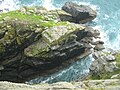
 Perched rock at the foot of Zennor Head
 -
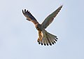 Common Kestrel
 -
 Eastern flank
 -
 Thrift, a coastal plant
 -
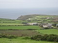 Zennor Head from inland
 -
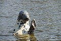 Grey seal
 -
 Horseback Zawn


References
- ^ a b c d The Z to Z of Great Britain, Dixie Wills, Icon Books, 2005, ISBN 1-84046-754-1, ISBN 978-1-84046-754-3
- ^ a b "About Zennor". Zennor Parish Council. Archived from the original on 22 April 2009. Retrieved 17 February 2012.
{{cite web}}: Unknown parameter|deadurl=ignored (|url-status=suggested) (help) - ^ a b c d e f g h i j k l Zennor Head Walk – National Trust, retrieved 30 October 2012
- ^ a b c d e Johnston, John Norman (7 June 1943). "Exercise Brandyball (film)". Imperial War Museum. Retrieved 27 October 2012. retrieved 27 October 2012
- ^ Will Fowler (18 June 2012). Allies at Dieppe: 4 Commando and the US Rangers: Operation Cauldron. Osprey Publishing. pp. Appendix 2. ISBN 978-1-78096-596-3. Retrieved 21 October 2012.
- ^ Dunning, James (2003). The Fighting Fourth : No. 4 Commando at war 1940–45 (First ed.). Stroud, [England] : Sutton, 2003. p. 109. ISBN 978-0-7509-3095-6. OCLC 630147678.
- ^ Zennor Headland, given to the National Trust (Commemorative Plaque). Zennor Head: The National Trust. 1953.
- ^ "Walk - Zennor". South West Coast Path. Retrieved 2 January 2013.
- ^ "The Coastal Footpath". Homepage.ntlworld.com. Retrieved 25 February 2012.
- ^ Champion, Jim (15 August 2009). "Coast path temporarily closed near Zennor Head". Geograph. Retrieved 31 October 2012.
- ^ "Penwith Heritage Coast". Britain Express. Retrieved 17 February 2012.
- ^ (Map). Zennor Village: Zennor Parish Council http://www.zennor.org/PDF/Zennormap.pdf. Retrieved 1 January 2013.
{{cite map}}: Missing or empty|title=(help) - ^ Walking in Britain; by David Else, Sandra Bardwell, Belinda Dixon, Peter Dragicevich. Lonely Planet
- ^ Ordnance Survey Landranger Map 203, Land's End & Isles of Scilly, 2002, ISBN 978-0-319-23148-7
- ^ Cornwall Wildlife Trust (2012). "Killas". Cornish Geology. Retrieved 25 February 2012.
- ^ Gradstein, Felix M.; Ogg, J. G. F.; Smith, A. G. A Geologic Time Scale 2004 (2004 ed.). Cambridge: Cambridge University Press. ISBN 0-521-78673-8.
- ^ G. A. Steven (1934). A Short Investigation into the Habits, Abundance, and Species of Seals on the North Cornwall Coast. Journal of the Marine Biological Association of the United Kingdom (New Series), 19, pp 189–501 doi:10.1017/S0025315400046580
- ^ West Penwith, Penzance & Land's End accessed 4 March 2012
- ^ Coombe, D. E., & Morisset, P. (1967). Further observations on Trifolium occidentale. Watsonia, 6, 271–275.
- ^ Sparrius, L. B., James, P. W., & Allen, M. A. (2005). The sorediate variety of Sclerophytomyces circumscriptus. Lichenologist, 37(4), 285–290.