
Handsacre
| Handsacre | |
|---|---|
 The A513 and the Crown Public house at Handsacre | |
| OS grid reference | SK0916 |
| District | |
| Shire county | |
| Region | |
| Country | England |
| Sovereign state | United Kingdom |
| Post town | RUGELEY |
| Postcode district | WS15 |
| Police | Staffordshire |
| Fire | Staffordshire |
| Ambulance | West Midlands |
| UK Parliament | |
Handsacre is a village in the English county of Staffordshire, England.[1][2]
Location
The village lies west of the larger village of Armitage. The village is 5.5 miles (8.9 km) north of the city of Lichfield and is 3.5 miles (5.6 km) south west of Rugeley. The nearest railway station is at Rugeley which is 3.9 miles (6.3 km) north west of the village. The village sits astride of the A513 road which runs from Tamworth to Stafford.[3]
Village Services
Handsacre has two shops, one of which is a convenience store and the other a newsagent. There is also a Chinese food take-away and a fish and chip shop. There are two pubs in within the village. The public housese are called The Old Peculiar[4] and The Crown.[5] The Crown is adjacent to the canal and has a beer garden. The Old Peculiar is on the corner of Hall Road. The Popular's Pub closed in 2008 and was demolished in June 2010. As of June 2011, twenty houses have been built and are currently occupied.
Schools
The village school is called Hayes Meadow Primary School.[6] The school cater for children from the age of 3 plus, who attend the purpose built nursery unit, to the age of 11. The Head teacher is B J Luck (retrieved 11 April 2013)[6] The school is also home to its PTA organisation, The Friends of Hayes Meadow (Charity number 1087977). The charity organises events such as Summer Fayres, BBQ's, Craft Fairs and the most successful fundraiser, the Santa Float. Events like these allow the charity to provide students with extra things such as climbing frames, play equipment, selection boxes etc.
Playgrounds
There is a children's play park at the end of Harvey Road on St Barbara's Road in the north easterly part of the village. The playpark was re-furbished in 2009.
Trent and Mersey Canal
The The Trent and Mersey Canal skirts around the norther edge of the village. This canal was designed and built by James Brindley who passed away in 1777, before the canal was completed. The A513 road crosses the canal with the Crown public house next to the bridge designated bridge 56 here. This bridge is a little way west of two further bridges which cross the canal which are Grade II listed structures. these bridges are designated bridges 59[7] and 60.[8]
Population
Handsacre has a population[9] of 5,355 people living in the ward of Armitage with Handsacre.
Modern Handsacre (A.D.1901 - Present day)
This section may have been copied and pasted from another location, possibly in violation of Wikipedia's copyright policy. (April 2013) |
The River Trent was undoubtedly the first means of travel along the Trent Valley and has probably seen traffic since the Mesolithic or Neolithic periods, whereas the A513 Road has possibly been in existence only since the early Medieval period. These ancient communication routes were augmented by the Trent and Mersey Canal which was designed by James Brindley but completed after his death in 1777 and now delimits the northern extent of the two villages of Armitage and Handsacre. Armitage Railway Station (SK 088159) was opened on the Trent Valley Railway in 1847 but was closed to passengers in 1960 and to goods traffic by 1969. (AHDS)
The only modern archaeology of any note in the village is a Second World War Air Raid Shelter situated just to the west of Boat House Lane (SK 080161) within the grounds of the Armitage Shanks Ceramics Factory, which remains in 'fair' condition according to the CBA Defence of Britain Archive. (AHDS)
The Etymology of the name Handsacre
This section may have been copied and pasted from another location, possibly in violation of Wikipedia's copyright policy. (April 2013) |
The Domesday spelling of the name is Hadesacre, but there should probably have been an 'N' in the name, since all later records have it, although they differ a lot in other respects. Other spellings are: Hendesacra (1167); Hundesacra (1176); Handesacra (1196); and Hondesacre (1242). Acre, when occurring in a place-name, generally means an area of marginally cultivable land, often on the edge of heath, high moor or marsh and in this case refers to marsh. The first part of the name is a lot harder to decipher; a hypothetical name Handa has been proposed as the origin, which seems more likely than any other suggestions. The meaning in that case is 'the land beside a marsh belonging to Handa. (Gelling & Cole, p. 264, 266; Mills, p. 163; Poulton-Smith, p. 58)
History
This section may have been copied and pasted from another location, possibly in violation of Wikipedia's copyright policy. (April 2013) |
HANDSACRE HALL. Three connected arms of a large rectangular moat, now drained of water with the northern arm partly filled-in, may be viewed at the eastern end of Manor Court Drive off Shropshire Brook Road (SK 0900 1565), and is all that survives of the former Medieval mansion of Handsacre Hall. The hall was built in the 14th century but the moated platform which housed it probably dates from the 12th century and was at first furnished with a wooden homestead. The drawbridge of the Medieval 'cruck house' building was still in place in the early-18th century but Stebbing Shaw states that the timber-framed mansion was derelict in 1798; he also reported a timber dated 1663 which probably records a major rebuild. The site was finally abandoned in the early-1960s and damaged by vandals in 1973 after which the majority of the house collapsed leaving only the front wall and parts of the side wings still standing. Excavations conducted by Staffordshire County Council in 1986-87 prior to the development of the modern housing estate recovered pottery ranging from the 12th to the 19th centuries. The architectural finds from the Medieval hall are now in the Avoncroft Museum and the excavation reports were published in The Journal of the Society for Medieval Archaeology in 1987, also in West Midlands Archaeology of 1986 and 1987. A substantial pond-bay associated with the hall lay to the south in the field known as Pool Meadow.
Medieval Handsacre (A.D.1066 - 1540)
In 1795 the stone foundations of a small rectangular building were discovered in a field named Mill Croft, directly opposite the north front of Handsacre Hall (SK 0898 1586). The building was identified at the time as a small church, possibly a manorial chapel associated with the nearby Hall, based on the fact that the neighbouring field was named Church Croft. The site now lies at the end of Station Drive close to the signals at the end of the railway platform and has been partly demolished by the railway cutting; nothing of the site is now visible. The only other remains of the Medieval village are three stone crosses: one wayside cross lay beside the A513 at the entrance to Church Lane (SK 0769 1626), and another lay beside the A51 at the entrance to Bardy Lane (SK 0666 1523) about 1 mile (2 km) south-west of Armitage, both of which have been lost. The only visible remnant is the shaft of a churchyard cross, now in two pieces, at the end of Church Lane in Armitage (SK 0771 1648 : SK 0773 1646), which was originally thought to be Norman but is probably of 19th century provenance. (AHDS)
Domesday Hadesacre (A.D.1086)
"LICEFELLE (Lichfield). It has already been described before. A woodland, 8½ leagues and 7 furlongs long and 6½ leagues and 8 furlongs wide, belongs there. These members belong to this manor: ... HADESACRE (Handsacre), land for 5 ploughs; Robert holds it. ... In these lands or outliers, 7 ploughs in lordship; 60 villagers and 22 smallholders with 25 ploughs. Between them all, meadow, 52 acres; a mill. The valuation is accounted for in the manor." (The Domesday Book, 1086, 2.22)
The Domesday Book lists fifteen villages, including Handsacre[10] and nearby Pipe Ridware, which lay within a very large area of woodland belonging to the city of Lichfield, measuring approximately 13.5 miles (22 km) long by 10.75 miles (17 km) wide and covering an area of over 146 square miles (380 km2). The Hadesacre entry states that there were five 'ploughs' of farmland attached to the village, amounting to an area of about 600 acres (2.4 km2), which was held by Earl Robert of Stafford. The actual number of villagers living in Handsacre during Domesday remains unknown, as does the amount of land farmed by them, also the amount of meadowland attached to the village and the amount of land, if any, farmed by the lord of the manor; these figures were presented as a total for all fifteen dependant 'vills' at the end of the entry.
Early-Medieval Handsacre
Again, the archaeological evidence for an entire historical period is represented in the area only by cropmarks, this time in the form of field boundaries displaying characteristics of the early-Medieval or Norman periods lying just south of the A513 Kings Bromley Lane (SK 1024 1684), between the road and the football ground. (AHDS)
Iron-Age Handsacre (c.800B.C. - A.D.43)
The only archaeology of this period comes in the form of an Iron-Age field system and pit alignment which has been recorded as cropmarks on aerial photographs about 0.5 miles (800 m) north-east of the village in the area to the south and east of the Bronze-Age barrow cemetery mentioned above, near Echills. The pit alignment consists of three large holes aligned roughly south-east to north-west and spaced roughly 0.25 miles (400 m) apart (SK 100170 : SK 104165 : SK 107161). (AHDS)
Bronze-Age Handsacre (c.2,500 – 700 B.C.)
The only Bronze-Age artifactual evidence from the area is a hoard of two polished stone socketed axe-heads and two bronze spearheads which were found in Armitage (SK0716) in 1782. The most interesting archaeological site in Handsacre itself belongs to the Bronze-Age period and lies north of the A513 Kings Bromley Lane about 0.75 miles (1,000 m) to north-east of the village where no less than six bronze-age round barrows have been recorded as circular cropmarks on aerial photographs (centred on SK 103169); this clustering of ancient burial mounds is known as a 'barrow cemetery'. Another Bronze-Age round barrow has been identified from circular cropmarks on A.P.'s on the opposite bank of the River Trent about 0.5 miles (800 m) north of the Handsacre barrow cemetery in the neighbouring parish of Hamstall Ridware (SK 103175), and a further three ring ditches, very likely representing more of these burial mounds have been located on A.P.'s on the north bank of the Trent (SK 083167) close by the Mavesyn Ridware causewayed enclosure. (AHDS)
Stone-Age Handsacre (c.10,000 - 2,000B.C.)
There is no archaeology of the Stone-Age period in Handsacre itself, but there is some interesting stone-age stuff in the neighbouring parishes. A Neolithic stone axe-head was found at Wychnor Glebe in King's Bromley (SK 099165) in 1888 and is now held at Lichfield Museum. The stone used in the manufacture of the axe is of Petrological Group VI and it is very likely, therefore, that the stone was quarried somewhere in the local area. By far the most interesting New-Stone-Age site in the entire Cannock Chase area lies opposite Handsacre on the north bank of the River Trent in Mavesyn Ridware (SK 085168), where a Neolithic Causewayed Enclosure has been recorded on aerial photographs. (AHDS)
Gallery
- Handsacre
-
 Handsacre Methodist Church
 -
 Trent and Mersey Canal at Handsacre
 -
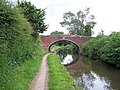 Grade II listed Bridge 59


References
- ^ OS Explorer Map 244: Cannock Chase & Chasewater: (1:25 000) :ISBN 0 319 46269 2
- ^ Map Details retrieved 11 April 2013
- ^ - Staffordshire A-Z County Atlas: 2011 Edition: Scale:3.8 inches to 1 mile (5.9cm to 1km)ISBN 978 1 84348 748 7
- ^ The Old Peculiar website retrieved 11 April 2013
- ^ Crown Inn website retrieved 11 April 2013
- ^ a b school website retrieved 11 April 2013
- ^ Listed Structure status-Bridge 59 retrieved 11 April 2013
- ^ Listed Structure status-Bridge 60 retrieved 11 April 2013
- ^ Key Population statistics retrieved 11 April 2013
- ^ The Domesday Book, Englands Heritage, Then and Now, Editor: Thomas Hinde,Staffordshire, Hansacre ISBN 1858334403