Ny-Ålesund
Ny-Ålesund | |
|---|---|
international research station | |
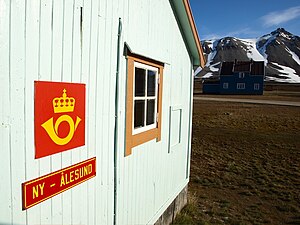
 The world's northernmost post office in Ny Ålesund | |
| Country | Norway |
| Syssel | Svalbard |
| island | Spitsbergen |
| Population | |
| • Total | 35 |
| Time zone | UTC+2 (CET) |
| • Summer (DST) | +3 |
Ny-Ålesund ("New Ålesund") is one of the four permanent settlements on the island of Spitsbergen in the Svalbard archipelago. It is located on Brøggerhalvøya and Kongsfjorden. Like the rest of Svalbard, Ny-Ålesund is administered by the Kingdom of Norway.
Ny-Ålesund is one of the world's northernmost settlements at 78°55′N 11°56′E / 78.917°N 11.933°E, and is the world's northernmost functional public settlement. It is 107 km away from Longyearbyen.
Today, it is inhabited by a permanent population of approximately 30–35 people. All of them work for one of the research stations — e.g. the Norwegian Polar Institute — or the logistics and supply company Kings Bay AS, which 'owns' and runs the research village. In the summer the activity in Ny-Ålesund is greatly increased with up to 120 researchers, technicians, and field assistants. At present, Norway, the Netherlands, Germany, United Kingdom, France, India, Italy, Japan, South Korea and China[1][2] all maintain research stations at Ny-Ålesund, although not all are inhabited year-round.
Ny-Ålesund is home to the new Arctic Marine Laboratory (the northernmost in the world), which was officially opened on 1 June 2005. With many open rooms and wet and dry lab spaces alike, the marine lab is particularly useful for countries that do not maintain permanent research stations in the area.
There are weekly flights between Ny-Ålesund and Longyearbyen for transport of scientists and other personnel. On ship cruises, Ny-Ålesund is a typical shore break. However, this tourism may cause interference with the sensitive scientific devices in the settlement, so tourists are closely observed. Visitors are supplied with a local map and are required not to stray off the marked path — a round-trip of about one kilometre from the pier. A number of information boards are placed strategically to explain the history and purpose of the various buildings; many are research establishments. There is one shop, a tiny museum and small post office, the northernmost in the world. In summer Arctic Terns nest on the ground alongside the path and may "dive-bomb" visitors who get too close.
The climate is mild relative to Ny-Ålesunds northern latitude, from the Gulf Stream that flows northwards from mainland Norway up the west coast of Spitsbergen. The mean temperature in the coldest month (February) is -14°C, while the warmest month (July) has a mean temperature of +5°C.[3]
Also in this area, to protect the local VLBI antenna, there is a 20-kilometre exclusion zone for devices transmitting between 2.1 and 2.5 GHz. This includes bluetooth, WLAN, and other wireless devices.[4] The settlement is served by Ny-Ålesund Airport, Hamnerabben. Since 1997 there has been a launch site, SvalRak, near Ny-Ålesund, for sounding rockets.
History

- 1916 — founded as a coal mining town, at first named Brandal City after the founder Peter S. Brandal
- 1926 — Roald Amundsen starts his North Pole flight in the Airship Norge
- 1962 — Kings Bay Affair - mining disaster (1962-11-05) kills 21 people; Norwegian government resigns in August 1963 due to this event, and mining is discontinued
- 1968 — the Norwegian Polar Institute opens a research base
- 1980s/90s — other nations increase their scientific activities, turning Ny-Ålesund into an international Arctic research base
- 2004 — China inaugurates the Arctic Yellow River Station, its first Arctic research station, in Ny-Ålesund on 2004-07-27
- 2008 — India inaugurates the Himadri Station, its first Arctic research station, in Ny-Ålesund
References
Photo Gallery
-
The magic of Svalbard at daybreak - View of Ny-Ålesund
-
Ny-Ålesund in summer
-
Dirigible launch tower for the Amundsen-Ellsworth-Nobile dirigible expedition
-
The Roald Amundsen monument and the North Pole hotel
-
Drei Kronen and Kongsbreen glacier view from Ny Alesund
External links
- British Antarctic Survey research Station
- Webcam at Ny-Ålesund
- Webcam: Hamnerabben Airport at Ny-Ålesund
- Streetview of Ny-Ålesund with short video information
- Web site of Kings Bay A/S, the local logistics company
- Netherlands Arctic Station
- Indian research station ‘Himadri’ at Ny-Alesund in the Arctic
- Italian research station "Dirigibile Italia"


