Hafelekarspitze
Appearance
| Hafelekarspitze | |
|---|---|
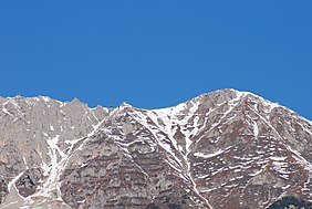
 The North Chain seen from Innsbruck. Centre: the Hafelekar top station, right: (east) the Hafelekarspitze | |
| Highest point | |
| Elevation | 2,334 m (AA) (7,657 ft) |
| Listing | Cosmic radiation station of the University of Innsbruck]] |
| Coordinates | 47°18′46″N 11°23′11″E / 47.312828°N 11.38632°E |
| Geography | |
| Parent range | North Chain, Karwendel |
| Geology | |
| Age of rock | Triassic |
| Type of rock | Wetterstein limestone [1] |
| Climbing | |
| Access | Nordketten Cable Car |
The Hafelekarspitze is a mountain in the so-called North Chain (Nordkette) north of Innsbruck in Austria.
Location and landscape
Below and west of the summit is the top station of Hafelekar, the second section of the Nordketten Cable Car at a height of 2,269 m (AA), from where the Hafelekarspitze may be reached in a few minutes by foot on a metalled path.
Not far from there is the Hafelekar Survey Station, a cosmic radiation observatory of the University of Innsbruck, the only one of its kind in Austria.
-
Summit cross on the Hafelekarspitze
-
The top station of the Nordketten Cable Car at the Hafelekar cirque
-
Research station and amateur radio hut (left)
External links
Wikimedia Commons has media related to Hafelekar.
- www.nordkette-austria.net – The website about the North Chain
- The Innsbruck Klettersteig
References
- ^ Geologische Karte von Bayern mit Erläuterungen (1:500,000). Bayerisches Geologisches Landesamt, 1998.


