
Talk:Control of cities during the Syrian civil war
| This is the talk page for discussing improvements to the Control of cities during the Syrian civil war article. This is not a forum for general discussion of the article's subject. |
Article policies
|
| Find sources: Google (books · news · scholar · free images · WP refs) · FENS · JSTOR · TWL |
| Archives: Index, 1, 2, 3, 4, 5, 6, 7, 8, 9, 10, 11, 12, 13, 14, 15, 16, 17, 18, 19, 20, 21, 22, 23, 24, 25, 26, 27, 28, 29, 30, 31, 32, 33, 34, 35, 36, 37, 38, 39, 40, 41, 42, 43, 44, 45, 46, 47, 48, 49, 50, 51, 52, 53, 54, 55, 56, 57, 58, 59, 60, 61, 62, 63, 64, 65Auto-archiving period: 14 days |
| This page is not a forum for general discussion about Control of cities during the Syrian civil war. Any such comments may be removed or refactored. Please limit discussion to improvement of this article. You may wish to ask factual questions about Control of cities during the Syrian civil war at the Reference desk. |
| This article has not yet been rated on Wikipedia's content assessment scale. It is of interest to the following WikiProjects: | |||||||||||||||||||||||||||||||||||||||||||||
Please add the quality rating to the {{WikiProject banner shell}} template instead of this project banner. See WP:PIQA for details.
Please add the quality rating to the {{WikiProject banner shell}} template instead of this project banner. See WP:PIQA for details.
| |||||||||||||||||||||||||||||||||||||||||||||


.svg)
| To help centralise discussions and keep related topics together, Template talk:Syrian Civil War detailed map redirects here. |
Template:Syrian Civil War sanctions
|
Index 1, 2, 3, 4, 5, 6, 7, 8, 9, 10 |
|
This page has archives. Sections older than 14 days may be automatically archived by Lowercase sigmabot III when more than 4 sections are present. |
Roads
Shouldn't this map show at least the major roads and railways? After all, maneuver is critical in warfare, and that would explain more why this or that city or village is strategic. — Preceding unsigned comment added by 24.8.182.120 (talk)
- Absolutely. Someone please create a version of the base Syria location map with those features drawn. Alternatively, we need a picture file that has syria roads on it and nothing else. I can then use the "overlay_image =" parameter in the "Template:Location map+" to overlay that "road file" on top of our map. For an example of the result of this parameter, see a "Location map+" where a picture file with arrows was overlayed on top of it. Unfortunately, i don't know how to create picture files. If anyone can create such a file (same size as our map; with a transparent background) and put it in commons, then i can overlay it on top of our map. Tradediatalk I brought this back from archives as this is still an ongoing issue. And while we are at this, it would be good to also draw Lake Jabbūl Tradediatalk
- I agree that adding some of the most important highways to the map would make it more useful. It would have to be done delicately, because it could quickly make the map very cluttered. Looking at road maps of Syria, I would suggest something showing a few major highways, along the lines of this (scroll down slightly), rather than something more like this, which would overwhelm the map. Hulahoop122 (talk)
- Good idea. Between those 2 examples, the difference seems more how the roads are drawn (thin red lines vs. wide light brown lines), than the number of roads. In some areas, there seems to be more roads on the first map with the roads in red.
- Note that our map is bigger, so we could probably place more roads (if appropriate) without problem. In some areas there are many alternative roads allowing easy passage around the main routes, so it might be a good idea to indicate that.
- With a good source map with the roads already on it (and not too many complicated things in the same colour), I could produce the road overlay. The colour of the roads could be changed to whatever you like.
- There is a map on my computer that might be good, with many roads, except it could be as much as 20 years old. (The latest date on the map is a 1994 border treaty.) It is better to have something not long before the civil war started.
- According to my map, most of lake Jabbul is dry much of the year. (All except the north-west corner.) It also has rivers and railways, which might be interesting to show. (the roads, water, and railways could be put on separate layers so as to be easier to maintain, if necessary. Not hard since they are all different colours.) André437 (talk)
- If you have the skills to put that map layer together, that would be great. You could post it on a test page, just as you did with all of the conflict icons you created, and see how the community reacts. Hulahoop122 (talk)
- Ok, as I have time. It could take a while, since I will have to use google maps or equivalent to fill in the few places where a small window overlay covers roads, etc in some areas, and also clean up any stray marks I find. (There are a lot of annotations, but mostly outside Syria.)
- I'll also have to adjust the scale and align it, which will be the most difficult part.
- I'll put the roads/water/railways in separate layers initially as well. Easy to do since they are separate colours. That way it will be really quick to modify (or remove) one without affecting the others.
- That icon project helped remind me of a few tricks with the software I use. (gimp)
- BTW, I have an unrelated idea for locations contested from one side only : using a semicircle open on the opposite side. And for truces, using a broken outside circle, instead of a continuous one. Just mentioning it as something to think about.
- I'll keep you posted :) André437 (talk)
- If you have the skills to put that map layer together, that would be great. You could post it on a test page, just as you did with all of the conflict icons you created, and see how the community reacts. Hulahoop122 (talk)
- This section disappeared for a while and I became occupied elsewhere, but my map turned out to be so overwritten with place names so as to be almost useless. Most roads, rivers, etc were obscured in many places. It would be faster to draw features freehand using google maps in satellite mode. Not one of my talents. So I can't help much with that.
- I've noticed that some waterways have been added. It looks really nice. André437 (talk)
- There are maps like that, already. Be patient, they load slowly because they are "Flash". - http://www.fps-predators.com/#/middle-east-conflict/4585140400 Shaded areas show more detailed maps of the same area (click on them to access). — Preceding unsigned comment added by Comins2008 (talk • contribs)
Question on East of Damascus
Does any evidence exist showing that the khan abu shaman base and battalion 559 remain in rebel hands? These are both shown as green but the rebels have no green towns in these areas. These are directly east of damascus. Any information on this area? — Preceding unsigned comment added by 169.231.67.155 (talk) 19:35, 28 August 2014 (UTC)
- They are rebel held. If regime had retaking them, at least pro-regime source would had talked about it. — Preceding unsigned comment added by 177.204.47.29 (talk) 21:08, 28 August 2014 (UTC)
- The rebels no have a a full control from a single town in these areas --Pototo1 (talk) 21:43, 28 August 2014 (UTC)
- so no evidence either way- nothing showing they are rebel or gov. — Preceding unsigned comment added by 169.231.3.204 (talk) 16:20, 29 August 2014 (UTC)
- These are desert areas north-east of Damascus. The area has many sand dunes and similar rolling terrain, which at least partly explains why the regime has been not retaken them. They don't have any strategic value except their proximity to Damascus. And the fact that the rebels at least had a large number of captured tanks there. There are many tank shelters to hide tanks from aviation. (This info was well documented when the rebels took the area.)
- Without any indication that the regime has recaptured the area, it is highly likely still rebel held. André437 (talk) 02:03, 31 August 2014 (UTC)
- How do they survive out in these dunes? No towns? No sources of food? Totally surrounded? We never hear of them attacking anyone? — Preceding unsigned comment added by 169.231.67.155 (talk) 03:01, 31 August 2014 (UTC)
- 1-The Dailystar gives more details about base 559. It says: "After seizing military base 559 in eastern Qalamoun last week, they found themselves under air attack Friday, as the regime sought to neutralize their capture of large quantities of weapons and ammunition. In the end, the rebels claimed they made off with 35 regime tanks – the biggest such haul of the war – while 70 were destroyed by regime aircraft." Notice that it says "they made off". According to online dictionary, "made off" means: "to depart in haste; run away." So this implies that the rebels are no longer at these warehouses. They took the tanks they could, and destroyed what they could not take so that the army could not use it again (not mentioning what was destroyed by the airforce). So at this point, these warehouses are probably destroyed & empty and we do not know if they are occupied by someone, or just abandoned. In any case, they no longer have a strategic importance. Therefore, this icon should be "commented out" of the map until more clear information become available.
- 2-There is no information about the present status of khan abu shamat. In any case, we know that the warehouses are empty from the chemical weapons. So at this point, we do not know if they are presently occupied by rebels, or army, or just abandoned & empty. In any case, they no longer have a strategic importance. Therefore, this icon should be "commented out" of the map until more clear information become available. Tradediatalk 01:38, 5 September 2014 (UTC)
- If we are removing icons/locations from the map simply for lack of news and strategic value, then most of Tartus province should go, as should the majority of miniscule, unimportant locations - most of the remote Kurdish towns, the ridiculous density of tiny towns around Qusayr, almost all of Deir el Zor province. If that is really the logic you are imposing, do it across the board, and not just for 2 rebel locations. I'm on board, if it's applied evenly. Til then, nope. Boredwhytekid (talk) 13:38, 15 September 2014 (UTC)
- No, we are not removing icons/locations from the map simply for “lack of news and strategic value”, but rather because a source (Dailystar) said rebels “made off” (= to depart in haste; run away) with the weapons & ammo. This raises “serious doubt” about the present status of these bases. Your examples are not good because there is no doubt that Tartus province is gov-held, Qusayr towns are gov-held, Deir el Zor province is ISIS-held (except in & around city where gov places are well documented). I had done the same for many red bases, a few months ago, for the same reason. Tradediatalk 00:16, 5 November 2014 (UTC)
Syrian Army captured more Towns in North Hama
Syria TV report with subtittles. https://www.youtube.com/watch?v=5wx-VBCu4X0
Latakia villages and Al-Masdar
i just want to inform the editors that editor Paolowalter used the Pro-government Source Al-Masdar to change some villages in Latakia to government control,and according to the consensus established we don't use government sources to show government advance,so i proposed to return the status of those as they where before they were changed using Al-Masdar. Alhanuty (talk) 03:18, 17 October 2014 (UTC)
- We did NOT establish a consensus. Do not lie to the editors. I already told you about Al-Masdar and its credibility. I propose that if you continue to lie to try and get your way that you be banned. 2602:30A:C01B:89F0:4C1F:A767:8E14:8CED (talk) 19:41, 17 October 2014 (UTC)
- Pro opposition map confirmed that regime forces on 1 October captured the village Ghunaymiyah and area near this village here and some areas near the city Salma. But as long as we do not have independent confirmation that the army captured the village Al Hawr. Hanibal911 (talk) 07:11, 17 October 2014 (UTC)
- So if we not have a confirmation from a reliable source that army captured the village of Al Hawr we will have to put this village again to under rebel control. Hanibal911 (talk) 07:36, 17 October 2014 (UTC)
Editors need to agree on a pro-gov source that can be agreed upon as reliable to balance the pro-op source of sohr . This needs to take into account that sometimes they get it wrong as does sohr but they must show rebel gains as well as saa gains .Pyphon (talk) 14:27, 17 October 2014 (UTC)pyhponhttps://en.wikipedia.org/w/index.php?title=Talk:Cities_and_towns_during_the_Syrian_Civil_War&action=edit§ion=51#
- Pyphon, please don't start a line with a space. Doing so suppresses formatting, causing the whole paragraph to be on one line, so (in this case) most of your paragraph was not visible. (fixed now) ... To indent, use ":", multiple times for more indenting. It would be a good idea to use the "preview" button to see how your post will look. (I always do that, and I have written documentation on Mediawiki formatting.)
- Note that the editors here agreed a long time ago that SOHR was a neutral source, not pro-opposition in its' reporting. This is admittedly rare for a source which obviously would prefer Assad gone, but the focus of SOHR is against human rights abuses, which are criticized whoever does them. Evidently the regime does a lot more abuses, as is noted by the UN.
- Just yesterday (thursday 16 oct) the UN secretary general Ban Ki-Moon declared that "Syrian civilians are in imminent threat from the regime of Bashar al-Assad". More details here.
Really? then suck your NEUTRAL SOHR http://syriahr.com/en/2014/10/the-regime-army-could-seize-a-village-and-a-cement-plant-in-aleppo/ "Saa took control of Jbayleh and the cement plant in north of the Central Prison of Aleppo" neutral idiot sohr is the biggest opposition bias cutting off snackbar deaths by counting them as civilians and blaming Assad for civilians dying in government controlled ares by shelling of the beheaders — Preceding unsigned comment added by 89.132.122.57 (talk) 17:12, 18 October 2014 (UTC)
- As for sources favouring the Assad regime that are reliable, it is doubtful that any group favouring a regime with Assad's track record of horrific human rights abuses would be reliable. That would be like trusting pro-Daesh/ISIS sources, which haven't (at least yet) come close to matching Assad's abuses. André437 (talk) 22:45, 17 October 2014 (UTC)
- Again, your pro-rebel bias blinds you. Your statement of the Syrian government committed more atrocities than ISIS is not supported by your linked source. Ban said that Assad was also a risk, not more so than ISIS. This "As for sources favouring the Assad regime that are reliable, it is doubtful that any group favouring a regime with Assad's track record of horrific human rights abuses would be reliable. That would be like trusting pro-Daesh/ISIS sources, which haven't (at least yet) come close to matching Assad's abuses." is nothing more than Original research which is prohibited on Wikipedia. Good job, you are 0 for 3 now in violating Wikipedia policy 2602:30A:C01B:89F0:4C1F:A767:8E14:8CED (talk) 03:02, 18 October 2014 (UTC)
this map is about who controls cities and towns not about human rights or inflated casualty figures so if a source weather it be pro-op or pro-gov show both gains and loss it should be regarded as reliablePyphon (talk) 09:33, 18 October 2014 (UTC)python
Andre sohr was not agreed as NEUTRAL but as reliable because he posted saa gains as well as rebel he is about as neutral as you arePyphon (talk) 09:42, 18 October 2014 (UTC)pyhpon
Al Masdar is a very reliable source...
- @Pyphon : could you kindly explain how "neutral" in the context of reporting differs from "reliable because he posted saa gains as well as rebel" ? I'm sure we would all like to understand your logic.
- Some sources still show bias in reporting despite sometimes showing opposition gains or sometimes showing regime gains. SOHR has consistently showed gains/losses from both sides. Note that since rebel gains tend to be under-reported (for various reasons), other unbiased sources (in reporting) are often called pro-rebel. André437 (talk) 07:28, 26 October 2014 (UTC)
- @IP6 (you really should get an account) : again you are confused about the concept of "original research", and where it applies. My statement comparing daesh/ISIS and Assad regime atrocities is based on a well known fact of the very high number of regime atrocities (you do remember the unanimous UN security council vote censoring the Assad regime for that ?), as well as the relatively small - but dramatic - number of daesh atrocities. That was only mentioned in the context of discussing the reliability of sources. You are also very confused about when sources are needed.
- BTW, although any normal human being relatively aware of the facts would prefer that the Assad regime looses power, that does not in itself make me biased in my analysis of the situation. Any more than the UN, which confirms the massive Assad regime atrocities. Having successfully alienated the vast majority of the Syrian population with its' atrocities (since 1971), it shouldn't be surprising that rebel opposition is a significant threat to the regime, despite massive foreign support for the regime. Your pro-regime bias is evident, whether intended or not. André437 (talk) 07:28, 26 October 2014 (UTC)
- Andre if a source is openly pro op or pro gov it can not be neutral but if it shows both sides gains it is a reliable source for editing this map you can not disregard a source because of its support for either side or as you stated for moral or other issues not related to the purpose of this map which is to show who controls which citys and towns . — Preceding unsigned comment added by Pyphon (talk • contribs) 18:09, 29 October 2014 (UTC)
Recent Link Replacement Request For Damascus Section
This edit request to Module:Syrian Civil War detailed map has been answered. Set the |answered= or |ans= parameter to no to reactivate your request. |
Hello Team, keep up the great stuff!
The last link of the section below leads to previous Jan-Jul 2014 timeline.
http://en.wikipedia.org/wiki/Cities_and_towns_during_the_Syrian_Civil_War#Damascus
Can you replace it with http://en.wikipedia.org/wiki/Timeline_of_the_Syrian_Civil_War_%28August_2014%E2%80%93present%29 which includes the current and recent atmosphere.
Thanks in advance.
78.170.183.172 (talk) 08:54, 23 October 2014 (UTC)
- I can't quite find the link you're referring to. What does the text of the current link say? When you reply, please change this question to unanswered (see box to the right on how to do this). Stickee (talk) 07:23, 29 October 2014 (UTC)
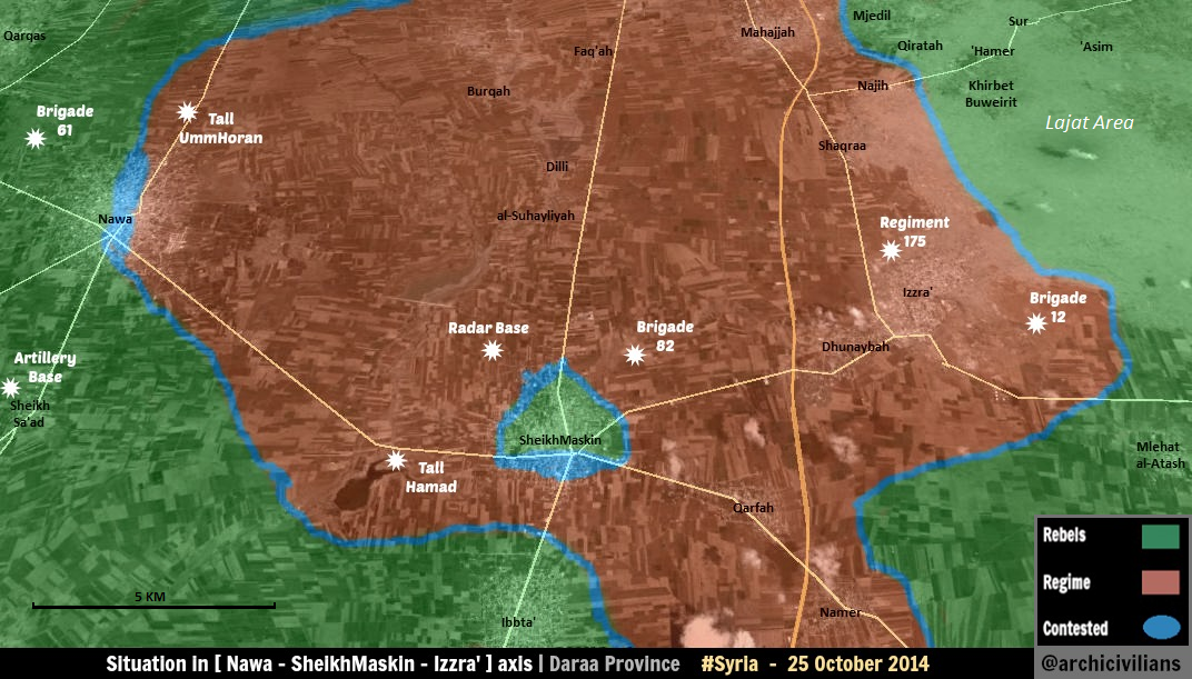
Nawa
Any source showing the Syrian army recapturing "brigade 61 base" west of Nawa ? — Preceding unsigned comment added by 109.175.75.56 (talk) 18:11, 25 October 2014 (UTC)
I just found this map https://pbs.twimg.com/media/B0zTxQTCEAASn8Q.png — Preceding unsigned comment added by Tierbook (talk • contribs) 18:14, 25 October 2014 (UTC)
Being the noob I am i shall just link the twitter account this stuff is on https://twitter.com/deSyracuse — Preceding unsigned comment added by Tierbook (talk • contribs) 18:17, 25 October 2014 (UTC)
Anyone with a neutral source?
There is another important question that should be asked, and it is this: why does Nawa have five military bases north of it? Are there actually five military bases all coincidentally surrounding the north of the town? Did the SAA predict that they would have to face a civil war and that they would soon have to fight in north Nawa? Wow, some really Nostradamus work right there by those military geniuses. Why are regime positions in surrounding areas being listed as military bases? Do you know how many rebel "military bases" we can put on the map based on this precedent? Anyways I'm not really expecting such biases to change, merely pointing them out to the objective reader. — Preceding unsigned comment added by 85.112.86.39 (talk) 09:52, 27 October 2014 (UTC)
Hasakah Kurds and ISIL
I see more towns turned black every day. Towns north of Hasakah city, north of Tell Brak and towards Ras al-Ayn crossing. No discussion, nu sources given. A major offensive of ISIL like that would raise media attention, and airstrikes. So, why are they black? — Preceding unsigned comment added by 84.31.204.195 (talk) 15:41, 26 October 2014 (UTC)
Yes, apparently the villages around Hasakah (Khabur) are still in YPG hands, YPG withdrew only from some checkpoints. https://twitter.com/deSyracuse/status/526632524370673664 Moreover, after 4 days there are no IS claims about any Hasakah offensive, so I would suggest to revert any editing waiting for more reliable sources. — Preceding unsigned comment added by 8fra0 (talk • contribs) 10:06, 27 October 2014 (UTC)
And the towns near Mardakah? Suddenly, ISIL seems to have taken six or seven villages there, without any source mentioned. — Preceding unsigned comment added by 84.24.43.183 (talk) 10:10, 27 October 2014 (UTC)
There is this twitter (kurdish) source: https://twitter.com/SeniorB/status/525614456496070657 Usually it is reliable, but after 4 days it's strange that there are no more sources/media attention. I suggest to revert that editing also. — Preceding unsigned comment added by 8fra0 (talk • contribs) 10:22, 27 October 2014 (UTC)
On the other hand, about the villages north of Tall Brak there is this source that confirms that IS seized two kurdish villages: http://aranews.net/2014/10/isis-extremists-control-villages-near-syrias-qamishli/ — Preceding unsigned comment added by 8fra0 (talk • contribs) 10:36, 27 October 2014 (UTC)
Change those towns back to yellow, no sources have been given to all these reverts! I'd say this is a nice ISIS map.SyAAF (talk) 13:28, 27 October 2014 (UTC)
Can´t find villages: Khirbet Orta and Girke Kere on the map which the article http://aranews.net/2014/10/isis-extremists-control-villages-near-syrias-qamishli/ refers to. Also miss sources for the other ISIS hold cities north of Tall Brak.Rhocagil (talk) 10:20, 28 October 2014 (UTC)
They are already in Wiki map, https://en.wikipedia.org/wiki/Template:Syrian_and_Iraqi_insurgency_detailed_map , named "Girke Kere" and "Khirbat 'Urti". The villages between Tall Brak And Khirbet Orta is quite logical that are fallen also in IS hands, even with missing sources. I've reverted the editing for the villages west of Serekaniye and west of Hasakah. 8fra0 (talk) 10:27, 28 October 2014 (UTC) (Thanks for info!Rhocagil (talk) 14:38, 28 October 2014 (UTC))
According to Firatnews the village of Aliya east of Tall tamr has been captured by YPG. Here is the cordinates for that village. Al-AliyahMouradiyan (talk) 14:49, 7 November 2014 (UTC)
Battalion 559 in Eastern Qalamoun
I know it might be an outdated subject but my (and our) goal is an accurate map. I have found many pro-opp sources stating that rebels retreated from the warehouses after looting them and so defending empty warehouses was useless. Pro-opp sources:
https://www.aksalser.com/?page=view_news&id=1bf19643b8e23f7cc01c87d035bfee97
http://justpaste.it/islamicfront559
http://www.syrianarmyfree.com/vb/archive/index.php/t-68912.html
So it might be a bit late but I suggest turning back the empty 559 Battalion back to red. ChrissCh94 (talk) 22:58, 26 October 2014 (UTC)
It has always struck me as completely irrational that the rebels would have maintained a presence at these bases as they are basically worthless. — Preceding unsigned comment added by 77.101.181.174 (talk) 00:25, 27 October 2014 (UTC)
- So we need marked this base again under control by army. Hanibal911 (talk) 05:53, 27 October 2014 (UTC)
Islamic front members are using this base as a checkpoint, it's empty but obviously not Government held. Either remove it or, but that wouldn't be a smart move as there is a noticeable number of rebels in this desert area. — Preceding unsigned comment added by DuckZz (talk • contribs) 08:57, 27 October 2014 (UTC)
Provide a source that the regime re-took this area please, the days of reverting to red based on outdated sources are over. — Preceding unsigned comment added by 85.112.86.39 (talk) 09:45, 27 October 2014 (UTC)
- After pro opposition sources said that the rebels left the base, so you can provide proof from a reliable sources that now this base still under control by rebels. Hanibal911 (talk) 11:38, 27 October 2014 (UTC)
I don't get it. In what part does it say rebels completely withdrew from that area ? I can only read a part saying number of rebels withdrew from the base after heavy artillery, and that was months ago. There would be some source about the Syrian army recapturing the base, not even PetroLucem i co. posted about that. — Preceding unsigned comment added by DuckZz (talk • contribs) 11:58, 27 October 2014 (UTC)
These are warehouses so they can't be used as checkpoints (besides they are exposed in the desert to air attacks). Yes rebels are present in the desert but that doesn't mean they control it (neither does the regime: it's a desert!).
Pro-opp stated they retreated --> THAT MEANS THEY RETREATED (The Islamic Front itself admitted in one of the sources I provided why they retreated).
P.S: The sources provided could easily be translated. And for the person complaining about changing "old/outdated" stuff: it's for the good of the map & the community :) ChrissCh94 (talk) 12:09, 27 October 2014 (UTC)
- DuckZz probably you are right and we do not need edit this military base to red! Hanibal911 (talk) 12:18, 27 October 2014 (UTC)
The retreat occurred months ago that's the point.. It went unreported by regime sources because they didn't even acknowledge the fall of the warehouses in the first place.. I mean it's quite obvious: Raid - take the tanks - retreat without casualties But if you guys view that pro-opp sources reporting pro-opp retreats as unreliable then we have an issue here. I'm neither pro nor anti-regime but some of you are biased. Modifications must be made to match reality not what some of you want. Trying to change something from red to green or vice-versa has become impossible here. Peace. ChrissCh94 (talk) 16:14, 27 October 2014 (UTC)
- Interesting argument in this section : there is no current information that it is occupied by either side, and since the last known occupants were rebels who (at some of which) retreated, it somehow must be designated regime held even without any known regime presence ? ... and that doesn't occur to proponents as a pro-regime bias ?
- Maybe we need an explicit means of indicating that a point is not (known to be) controled by either side (other than removing it from the map). Maybe colour grey, or the violet used for truce areas ? Or maybe a "?" icon ? However I would favour leaving it green. André437 (talk) 03:39, 28 October 2014 (UTC)
- André437 you have a point here. But I am by no means biased. Here it may seem I'm pro-regime but if you look at other posts I might seem pro-opp. Point is all I want is accuracy nothing more. Cheers ChrissCh94 (talk) 08:48, 28 October 2014 (UTC)
- 1 reason for leaving those 2 bases green - they are the only indication on our map that there is any rebel presence to the east of Damascus/in the wilderness around Palmyra. There are still sporadic attacks and asymmetric warfare in that area, and if we remove Battalion 559 and the other base, our map will indicate complete SAA dominance from Damascus clear across the Deir el Zor - which is more inaccurate than leaving the bases as is. Boredwhytekid (talk) 13:15, 30 October 2014 (UTC)
- Sorry, but you will have to find a different way to mark “rebel presence to the east of Damascus”. Our map is concerned with cities, towns, bases, etc. We give information about who control these objects, and we don’t want to give misleading information. We are not focused on describing “area control”. There is already a map that does describe “area control”: https://en.wikipedia.org/wiki/File:Syrian_civil_war.png. Tradediatalk 20:58, 5 November 2014 (UTC)
Idlib
Since yesterday, rebels have started a large battle for Idlib-city and the surrounding villages/army checkpoints. Sources:
1. http://www.lbcgroup.tv/news/184940/al-qaeda-linked-syrian-islamists-attack-g 2. http://eaworldview.com/2014/10/syria-developing-insurgents-launch-major-attack-idlib-city-northwest/ 3. http://www.trust.org/item/20141027100921-v5sqv/ 4. http://syriahr.com/en/2014/10/violent-clashes-continue-4-fighters-from-jabhat-al-nusra-detonate-themselves-in-idlib/
Mastumah hill to green, Idlib and Mastumah to contested. Maybe green rings around checkpoints south and west of Idlib city? — Preceding unsigned comment added by 84.24.43.183 (talk) 11:37, 27 October 2014 (UTC)
- Such large cities like Idlib which is the capital of the province, we do not just noted their as contested. More correct to note the disputed portion or create a map as it has done for the city of Deir Ez Zor, Dara and Hasaka. Hanibal911 (talk) 11:47, 27 October 2014 (UTC)
I've added Tall Mastumah as rebel held according to SOHR. That's enough for now. The attacks are led by Al Nusra, famous for hit and run tactics. The situation will be much clearer in a day or two.DuckZz (talk) 11:51, 27 October 2014 (UTC)
Al Nusra in Idlib. Captured one building. Marked as contested until a more detailed map is available http://www.dailystar.com.lb/News/Middle-East/2014/Oct-27/275482-al-qaeda-linked-syrian-islamists-attack-government-held-idlib.ashx#axzz3HL57x6SNAriskar (talk) 12:03, 27 October 2014 (UTC)
- Agree! Because reliable sources only reported that the rebels had infiltrated to the government-held Idlib and stormed the government building in Idlib but did not say that clashes go throughout the city.ReutersThe Daily Star It could be a separate group, or as it was in the city Hasaka when ISIS captured part of the district in the city and we made a map and pointed out the area under their control. Also this is not the first attempt of rebels to capture the city and they all ended in failure. So either we need to find out which area are fights and mark it as contested or to create a map for this city how for Aleppo or Hasaka. Hanibal911 (talk) 12:10, 27 October 2014 (UTC)
- Also now SOHR said that clashes taking place between regime forces backed by NDF against Islamic battalions and Jabhat al-Nusra around regime checkpoints around Idlib and al-Mastuma camp and reports that Islamic fighters take over al-Mastuma hill by.here So no need to hurry edit the map! Hanibal911 (talk) 12:23, 27 October 2014 (UTC)
- Agree! Because reliable sources only reported that the rebels had infiltrated to the government-held Idlib and stormed the government building in Idlib but did not say that clashes go throughout the city.ReutersThe Daily Star It could be a separate group, or as it was in the city Hasaka when ISIS captured part of the district in the city and we made a map and pointed out the area under their control. Also this is not the first attempt of rebels to capture the city and they all ended in failure. So either we need to find out which area are fights and mark it as contested or to create a map for this city how for Aleppo or Hasaka. Hanibal911 (talk) 12:10, 27 October 2014 (UTC)
sohr says saa recaptured goverment and police hq.full of idlib city now saa control. here 213.74.235.122 (talk) 12:25, 27 October 2014 (UTC)
- I am sorry but the link which you have provided the broken. Hanibal911 (talk) 12:41, 27 October 2014 (UTC)
Both sources say it stormed a government building and but there is no saying that they have captured it and both sources say government forces confronted them.This kind of lone attacks are not enough to put a city contested.The attack was hit and run like the one in the Damascus suburb of Midan so Idlib city stays government held as there are no continued clashes in the city on the other hand the real battles are ongoing around Mastumah hill here which is the main battle front for now.To change Idlib city to contested we need a lot more then a source that says they attacked a government building and killed a few soldiers as there are many slipper cells that would attack a checkpoint and the disappear in thin air after the attack.Examples are the suicide attacks in Homs and hit and run attacks in Damascus where they fire a few shots and as soon as the army counters they run away.Daki122 (talk) 12:33, 27 October 2014 (UTC)
- SOHR clear said that violent clashes continue between regime forces backed by allied gunmen against Islamic battalions and Jabhat al-Nusra around regime checkpoints in Idlib province after the first party attacked regime bastions and checkpoint around Idlib and al-Naoura.here Hanibal911 (talk) 12:44, 27 October 2014 (UTC)
- Also other source said that Syrian army repelled a major attack was carried out by armed rebels on the barriers on the outskirts of the city of Idlib.Al Hadath News Hanibal911 (talk) 12:50, 27 October 2014 (UTC)
SOHR says saa recaptured government building and police hq .Full of idlib city now under saa control.(Rebels slipper cells only captured government building and police hq yesterday night ) source: http://www.syriahr.com/archives/33812Hwinsp (talk) 12:55, 27 October 2014 (UTC)
Video from state tv inside idlib city shows rebel slipper cells who tried to storm government building: https://www.youtube.com/watch?v=D9MC2Ylk5zoHwinsp (talk) 12:58, 27 October 2014 (UTC)
Also Petolucem posted that the SAA/NDF have recaptured Tall Mastume checkpoint https://twitter.com/PetoLucem/status/526712137264406528 Back to red!SyAAF (talk) 13:30, 27 October 2014 (UTC)
Congratulation agains braindead mods(most of them) edit everything after 2 al qaeda "activist" tweet and some biased report, it is sure nusra will attack Idlib after losing whole Hama, the hill is already retaken, and SAA repulsed the attack on Idlib. Contest my ass — Preceding unsigned comment added by 89.132.122.57 (talk) 14:43, 27 October 2014 (UTC)
- SOHR said that regime forces re-captured the two buildings of the Governor’s Mansion and police headquarter in the city of Idlib. The violent clashes between the regime forces and the Islamic battalions are still occurring on the outskirts of city Idlib.SOHR Hanibal911 (talk) 16:45, 27 October 2014 (UTC)
- Pro opposition source Archicivilians confirmed that rebels retreated from the city Idlib, claiming that they planned to control some areas around it only (mainly Tall Mastumeh).here Hanibal911 (talk) 19:22, 27 October 2014 (UTC)
Alright, so let's make a list if we follow this logic:
1. Busra al-Harir (Daraa) to green: no sources of fighting for several days 2. Huwajyah and Al-Huwash (Hama, Ghab Plain) to green: no sources of fighting in weeks 3. Tabarat al Khashir (near Abu ad Duhur airbase) to green: same cause
Can I continue? Editing this map is always becoming a game of pro-SAA versus anti-SAA, but we should at least draw one line. I noticed that red contested towns only stay that way for a short time, because if there is no source of continued fighting it reverts to red. Green dots however can stay contested for months (Tasil, for example). — Preceding unsigned comment added by 84.24.43.183 (talk) 16:13, 27 October 2014 (UTC)
- Firstly, according to data pro opposition source dated 20 October the villages Huwajyah and Al-Huwash (Hama, Ghab Plain) still contested.here Likewise, the city Busra al-Harir (Daraa)here But in the situation with the city of Tabarat al Khashir maybe you're right. And the issue about contested cities have long been worried the many editors but we can not simply edit based on our assumptions. Hanibal911 (talk) 16:34, 27 October 2014 (UTC)
- You are right. This is due to the nature of the way the rebels fight. The rebels are insurgents. It is very common for then to launch hit and run attacks. So, when we hear of an attack but with no follow up, we assume it was a hit and run and change the town back to red. The Syrian Army is not an insurgent force, so when they attack a town, they are there in earnest. 2602:30A:C01B:89F0:50D2:46CF:1649:D16B (talk) 21:27, 27 October 2014 (UTC)
One of the reasons the rebels often do hit-and-run attacks is to get their share of heavy arms and munitions supplied (to the regime) by Iran and Russia. That is where the majority of their heavy arms come from. Despite being nowhere near as well armed, the rebels have been able to hold many areas despite concerted regime attempts to take them. (e.g., Douma, the largest city in proximity to Damascus.)
In my view, it is a mistake to assume that the rebels leave without some confirmation. Usually it is provided by sources such as archcivilians cited above, usually called pro-rebel here, but generally accurately reflecting the situation on the ground. (According to other sources.) An archcivilian post said that most of the military vehicles and tanks used in the attacks around Idlib came from Tall Mastumeh. André437 (talk) 04:55, 28 October 2014 (UTC)
West Raqqah
So those towns have been reverted to black without discussion and without source a couple days ago. I'd like to see sources for this revert otherwise we'll have to change it back to green!!, it's not the first time these towns changed without source.SyAAF (talk) 13:56, 27 October 2014 (UTC)
- At least two maps (one pro-opp & anti-ISIS and other neutral, I think) show Western Raqqah as ISIS-held.--HCPUNXKID 23:37, 27 October 2014 (UTC)
Tell Mastuma
Pro opposition source said that according to pro Rebels news agency, Syrian troops retook Tall Mastumeh.here I'm not going to rush edit Tell Mastuma on the map because I want search for more data. So if someone has more information on the situation in this area please provide them. Hanibal911 (talk) 07:54, 28 October 2014 (UTC)
video from syria state tv today shows tell mastuma is under saa control : http://www.youtube.com/watch?v=sBKEvB8YCP8&feature=youtu.be212.252.198.94 (talk) 12:52, 28 October 2014 (UTC)
On Map for Al-Nusra Front need new color?
Al Nusra Front fights against other rebel groups. Perhaps in the near future we will need to noted the towns and villages which monitors Al Nusra Front in another color in contrast to those towns and villages which are under the control of FSA and its allies. Because SOHR reported that after clashes today and yesterday between al- Nusra Front and Jund al- Aqsa Organization from one side and the Syria Revolutionaries Front in the town, Al- Nusra Front seized 7 towns and villages in Idlib (Balyon, Kensafrah, Eblin, Abdita, Mshoun, Mgharah, Shnan) The clashes also resulted in death of some fighters from both sides.SOHR Hanibal911 (talk) 08:09, 28 October 2014 (UTC)
Would be a good idea but let's wait until something bigger happens. These clashes may be just between few smaller groups and not the entire Al Nusra front vs SRF. As as I know there are no clashes between Free Syrian Army members and Al Nusra, that would also mean you have to create a color for the SRF, too much for this map. The're probably some disagreements in Idlib about who has the authority to control a village/town. As you can see they have no problem in Daara, Aleppo etc.DuckZz (talk) 08:30, 28 October 2014 (UTC)
- Also in late July some sources repoted that Al-Nusra Front decided to act independently and began fighting against the FSA and in the wake behind ISIS wants create your caliphate.hereherehere Sources said that Al Nusra Front have seized three strategic towns on the border with Turkey in a major blow to US-backed moderate rebels. Nusra’s seizure of Azmarin, Salqin and Harem in Syria’s Idlib province came only four days after the group seized Darkoush, another border town, from the Syrian Revolutionary Front, a moderate group that is part of the Western-backed Free Syrian Army. Rami Abdurrahman, the head of the SOHR, said he believed the capture of the four towns was Nusra’s effort to build a geographically contiguous area that would be declared its Islamic state. Also there have been several indication that of Front Al-Nusra intention to distance itself from other rebel groups.hereherehere SOHR confirmed in late july that Al Nusra continued clashes against other rebel groups.here Hanibal911 (talk) 09:31, 28 October 2014 (UTC)
Sounds like an interesting idea. Rhocagil (talk) 10:04, 28 October 2014 (UTC)
My suggestion is, we wait for something bigger, Al Nusra still cooperates with rebels in Idlib, not to mention other parts of Syria. If you really want to put some towns under their control, use a dark green color with the name "rebels", light green should stay "opposition".DuckZz (talk) 11:24, 28 October 2014 (UTC)
- Just at the moment the situation is very similar to the situation with the Islamic State. Then also there were those who did not believe that the Islamic State can secede from the main body of the rebels, and will fight against them. And they were totally against what would mark cities and villages which was under control by ISIS to other color. And were wrong. Just as you can have noticed the Air Force of International coalition not bombed positions FSA in unlike positions ISIS and Front Al Nusra. Hanibal911 (talk) 11:46, 28 October 2014 (UTC)
——— The regime forces took controlled over the farmlands of Hosh Farah near the town of Mid’a in the Eastern Ghota after violent clashes with al- Nusra Front, the rebel and Islamic battalions. Source: SOHR Edit Map please! — Preceding unsigned comment added by 80.153.17.8 (talk) 12:12, 28 October 2014 (UTC)
- Also today SOHR reported that about violent clashes between Front al- Nusra and Jund al- Aqsa Organization from one side and the Syria Revolutionaries Front in the town al- Barah where the clashes have expanded to reach to Ma’arret al- Nu’man area.herehere Hanibal911 (talk) 12:20, 28 October 2014 (UTC)
Definitely I think we should be prepared for another colour for al-nusra and allied jihadists. From the reports I've seen, during the last few weeks in Idlib, they have attacked a number of smaller elements of the FSA-associated SRF coalition. Much of al-nusra retreating from Deir ez-Zor went to Idlib. The SRF doesn't want to divert its' resources to wage a full-scale war with al-Nusra, but it could still come to that. At the moment I don't see much risk of al-Nusra / FSA conflict elsewhere. André437 (talk) 14:16, 28 October 2014 (UTC)
I don't think this will be a correct thing to do because jbaht alnusra most of them are considered from syrian opposition more than AQ and fight with rebels everywhere, changing it to another color will be ok if they will be a separated group fighting rebels like isis, not like now they are fighting one group only. al-nusra has many allies from rebels like ahrar alsham, jund aqsa, fsa groups in qalamon and many others. — Preceding unsigned comment added by 83.110.142.181 (talk) 17:34, 28 October 2014 (UTC)
- SOHR was informed that Jabhat al-Nusra fighters have taken over the Syrian Revolutionaries Front checkpoints in Ma’ra al-Nu’man. Clashes took place between the two sides in al-Naour checkpoint which is a bastion for the SRF north of the city, the clashes ended with taking over the checkpoint by Jabhat al-Nusra.here I think that for now we not have more doubt that Front Al Nusra fights against one of the main rebel groups in the province of Idlib. And now it will not correct and further mark the towns and villages which are under the control of Front Al Nusra well as the as now we mark the cities or villages which now under control by Syrian Revolution Front. We need a new color for the Front Al Nusra. Hanibal911 (talk) 19:15, 28 October 2014 (UTC)
Hanibal, forget about that because since jabht nusra considered as rebel ally, otherwise the map will be very crowded and it will include many mistakes because jabht nusra also sharing control of parts of many villages in syria with other rebels, so this will show for some viewers as nusra is only presence in idlib. Also they fight the saa and isis with rebels. — Preceding unsigned comment added by 83.110.142.181 (talk) 20:42, 28 October 2014 (UTC)
- I totally agree with Hanibal911 at this point. Ma'ra al-Nu'man is a key rebel area in Idlib, since 2012. Effectively al-Nusra has declared war against the FSA in Idlib (of which the SRF is an important part).
- In most areas, al-Nusra is a minor force among the rebels, their propaganda exaggerating their importance. So at least initially we would only have to be concerned about Idlib, and maybe the Qalamoun and Aleppo. Just areas where they are in conflict with the mainstream moderate and islamic rebels. (In Daraa & Quneitra they are a very minor force, despite their hype.)
- So we have to decide the colour. I tend to favour a medium grey, to contrast with Daesh/ISIS black. Calling it "al-Nusra" or maybe "jihadist". How does that sound ? André437 (talk) 22:38, 28 October 2014 (UTC)
- Here's SOHR reports about clashes Front Al Nusra against the other rebel groups in the province of Aleppo.here That confirms my assertion that need new color for mark on the map cities or villages which under control the Front Al Nusra. So it is not correct that the towns or villages which is now under the control of Front Al Nusra marked by green dots. Hanibal911 (talk) 13:16, 29 October 2014 (UTC)
Clashes have taken place only for the last two days. If they keep it up for the next week than we discuss a color for Nusra only. Lets wait for now to see if the clashes will expand or die down. EkoGraf (talk) 13:34, 29 October 2014 (UTC)
My opinion is to wait and see if the infighting escalates or dies down if the fighting escalates we should with out a doubt give Al-Nusra a new color but for now I think we should wait and see what happens next and will other groups join in the fighting on the sides of one of the two warring parties.If clashes wind down and stop my opinion is that we should just make an article about the clashes and nothing more.Daki122 (talk) 13:51, 29 October 2014 (UTC)
- Agree! Hanibal911 (talk) 14:07, 29 October 2014 (UTC)
- It is too early, change will be needed only if the clashes esclates to a full war. It would be difficult
anyway to separate the territory held by the two warring sides .Paolowalter (talk) 20:17, 29 October 2014 (UTC)
- Agree with Paolowalter, too soon to add Nusra as a different player, let's wait and see how situation evolves...--HCPUNXKID 23:43, 29 October 2014 (UTC)
Let's keep track - here - of what exactly Nusra holds, as opposed to the FSA/SRF SOHR ISW So that when/if the time comes, we know what to mark as distinctly Nusra-held. Daily Beast "...the al-Qaeda affiliated al Nusrah Front, which has opened up a third fighting front against the FSA..." daily beast yahoo ISW Boredwhytekid (talk) 15:46, 31 October 2014 (UTC)
I think it´s getting more and more clear that the cooperation between FSA and Al Nusrah is coming to an end; Syria 'moderate' rebels lose ground to Qaeda (News from Al Jazeera) Rhocagil (talk) 15:56, 1 November 2014 (UTC)
Change Nusra's color please. The purple color is currently used on the Damascus map to indicate truce areas. We don't want truce areas and Nusra areas to look the same. Thanks. Kami888 (talk) 05:18, 7 November 2014 (UTC)
 Done Hanibal911 (talk) 12:45, 7 November 2014 (UTC)
- Thank you. Although, grey appears to blend in with the provincial and state boundaries a little too much, and in general doesn't look very distinctive. Perhaps another color? Kami888 (talk) 19:04, 7 November 2014 (UTC)
Howsh Al-Fareh
SAA got control of this area in East Ghuta and areas around Tal -Kerdi should be marked as contested area.151.238.164.7 (talk) 12:38, 28 October 2014 (UTC)
http://www.almayadeen.net/Latest/ryaFOLElEkOfQqPSAI,uUQ/%D8%B3%D9%88%D8%B1%D9%8A%D8%A7-%D8%A7%D9%84%D8%AC%D9%8A%D8%B4-%D8%A7%D9%84%D8%B3%D9%88%D8%B1%D9%8A-%D9%8A%D8%AD%D9%83%D9%85-%D8%A7%D9%84%D8%B7%D9%88%D9%82-%D8%B9%D9%84%D9%89-%D8%A8%D9%84%D8%AF%D8%A9-%D9%85%D9%8A%D8%AF%D8%B9%D8%A7-%D9%81%D9%8A-%D8%A7%D9%84%D8%BA%D9%88%D8%B7%D8%A9-%D9%88%D9%8A%D8%AA%D9%82%D8%AF SOHR also confirmed that.MZarif (talk) 13:04, 28 October 2014 (UTC)
- Syrian army took control over the farmlands of Hosh Farah near the town of Mid’a in the Eastern Ghota.SOHR Hanibal911 (talk) 14:11, 28 October 2014 (UTC)
Kobane Villages
Who and why did delete the 9 villages near kobane: on the west 5 villages, east 2 villages and south 2 villgaes and the grain silos change it back Lindi29 (talk) 12:54, 28 October 2014 (UTC)
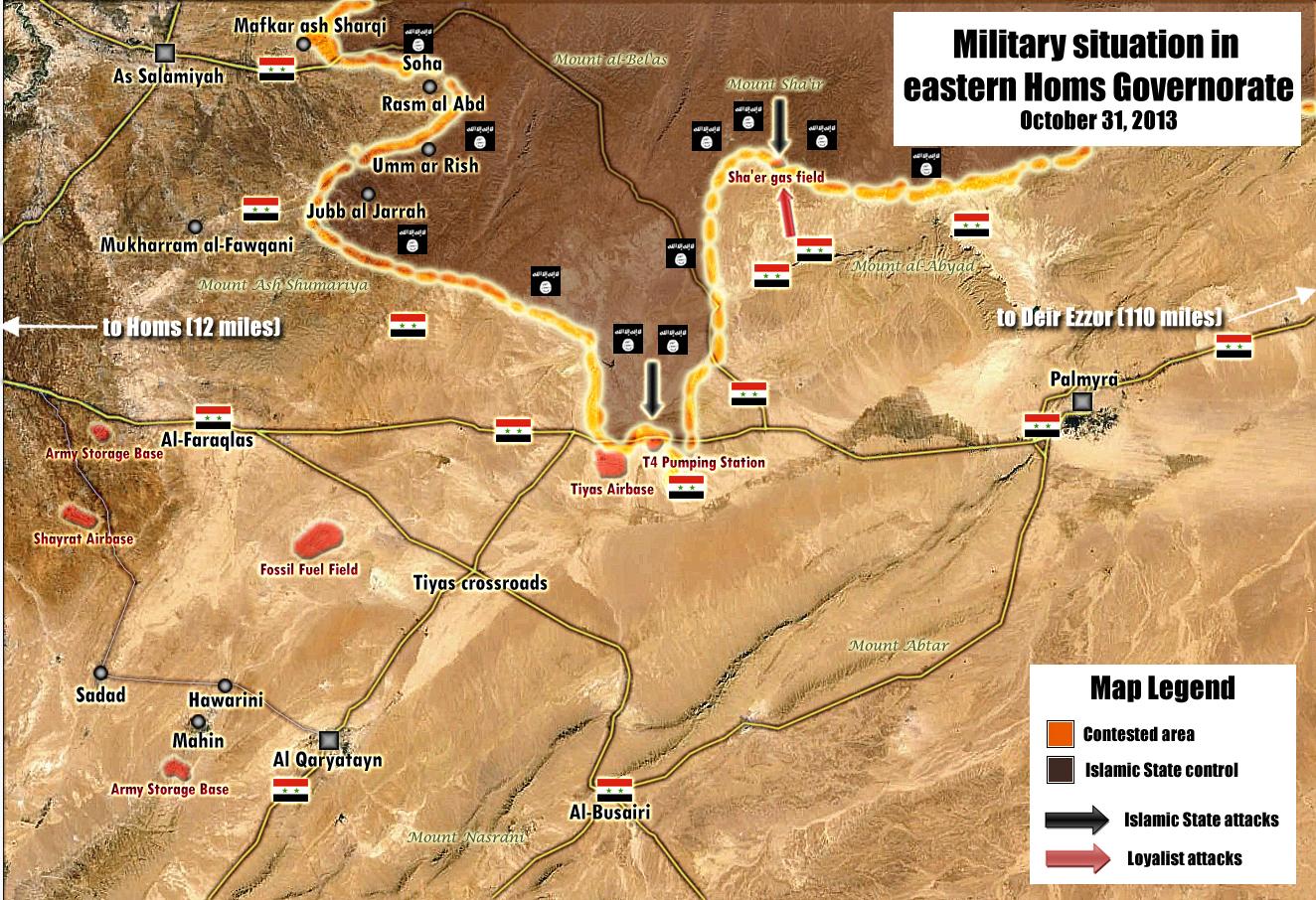
Shaer gas field
According to SOHR Shaer gas field and other 2 fields in the same area are now under IS control...http://syriahr.com/en/2014/10/isis-gain-control-on-3-gas-fields-in-shaer-area/ Need to change them to black, or at least Shaer( the other 2 are not mentioned and I don't know if they are located on this map).Fab8405 (talk) 17:20, 28 October 2014 (UTC)
read carefully , sohr says isis captured 3 gas field in shaer AREA. Shaer is a mountain north of palmyra.Sohr doesnt talk about shaer gas field. Shaer gas field is still under saa control.Hwinsp (talk) 17:29, 28 October 2014 (UTC)
Pro-Gov and pro-opp sources saying IS captured the 101 102 and 103 oil wells east of Shaer (the same ones NDF captured last week). IS is now mounting an offensive against the main Shaer gas field which is still under SAA Control: https://twitter.com/EjmAlrai/status/527133136417996801 https://www.facebook.com/Tarek.s.Ali1916/posts/863034517040679 ChrissCh94 (talk) 18:04, 28 October 2014 (UTC) — Preceding unsigned comment added by ChrissCh94 (talk • contribs) 18:01, 28 October 2014 (UTC)
- SOHR not said that IS taken the Sha'er gas field. SOHR said that IS took control on 3 gas fields in Sha’er area after violent clashes against regime forces.here But in this area there are many gas fields and we need more data before we editing their on map. Hanibal911 (talk) 18:58, 28 October 2014 (UTC)
- Also no one source not said about Oil wells. Pro government source said that IS(Daash) regain control of the gas wells 101, 102 and 103. And pro opposition said that IS control Shaeer well 101, 102 and 103 and and probably he also said about gas wells 101, 102 and 103.here And today SOHR said that IS took control on 3 gas fields in Sha’er area after violent clashes against regime forces.here And we are left to figure out where they are located in the area. And for those who did not know that in this situation the gas fields and gas wells it is almost the same. But as I early said in Shaer area too many gas fields but Sha'er gas field is the largest in this area. Hanibal911 (talk) 19:41, 28 October 2014 (UTC)
Excuse my mistake between Oil wells/gas fields. But as far as I know many neutral and pro-regime sources (mentioned above) did say that the 101 102 and 103 gas fields have fallen to ISIS. They are located east to the main and biggest field which is Shaer gas field. So my vote would be 3 black dots east of Shaer gas field and a partial siege of the latter. ChrissCh94 (talk) 21:50, 28 October 2014 (UTC)
Just put a black circle around Shaer oilfield.Alhanuty (talk) 00:25, 29 October 2014 (UTC)
- Alhanuty! Maybe you have had to mean Shaer gas field. Hanibal911 (talk) 07:55, 29 October 2014 (UTC)
http://justpaste.it/gzwshr1 Shaer is now under full control of IS. Fighting is now being reported around Tiyas and T4 Pump Station. 173.209.212.207 (talk) 00:27, 31 October 2014 (UTC)
SOHR "ISIS gain control in Shaer gas field"... " the IS took control on wide areas in Shaer Gas field in the eastern countryside of Homs, after violent clashes against regime forces, what forces the second party to pull back from the area, clashes continue between the two sides in the outskirts of the field in an attempt by regime forces to gain control in the area." Boredwhytekid (talk) 15:05, 31 October 2014 (UTC)
Mayda,a eastern Ghouta
Al masda posted SAA have taken Mayda.a but we have to wait for other sources as many regard him as to biased Pyphon (talk) 19:46, 28 October 2014 (UTC)pyphon
No regime news outlet (not even their official paper/TV) mentioned it. Stays rebel held for now. ChrissCh94 (talk) 21:57, 28 October 2014 (UTC)
Confirmed by Peto Lucem's map https://twitter.com/PetoLucem/status/527178074522406912. And http://www.almasdarnews.com/article/updated-battle-map-east-ghouta-saa-enters-new-frontier/. Paolowalter (talk) 23:24, 28 October 2014 (UTC)
-Peto Lucem's maps are made by the same guy (@KeepingTheLeith) who writes al-Masdar. While his maps are good, he's pro-regime and can't be used as a source. No SOHR or other corroboration of SAA taking Maydaa yet. — Preceding unsigned comment added by Nhauer (talk • contribs) 23:48, 28 October 2014 (UTC)
Al-Masdar is written by @KeepingTheLeith, but he is not Peto Lucem, who in fact makes the maps.
can we put madaya as red? or we should wait confirmation from sana? jobar is falling soon — Preceding unsigned comment added by 94.102.233.227 (talk) 13:24, 29 October 2014 (UTC)
- No change until we get a pro- op sourcePyphon (talk) 14:08, 29 October 2014 (UTC)pyphon
- Agreed ... (reminder : don't start a line with a space - fixed) André437 (talk) 18:59, 29 October 2014 (UTC)
- Agree! We need confirmation of this data from reliable source or in extreme case from pro opposition source. Hanibal911 (talk) 19:26, 29 October 2014 (UTC)
- Agreed ... (reminder : don't start a line with a space - fixed) André437 (talk) 18:59, 29 October 2014 (UTC)
2014 Idlib city raid- ISIS
These article: http://www.dailymail.co.uk/news/article-2810598/Up-70-Syrian-army-chiefs-beheaded-Isis-jihadis-make-advance-second-city-Idlib-held-Assad-s-forces-year.html http://www.independent.co.uk/news/world/middle-east/isis-attack-on-idlib-assads-army-leaders-slaughtered-as-jihadists-storm-syrias-second-city-9822023.html and http://www.thedailystar.net/isis-launches-assault-on-idlib-47882 all claim a very different story from what we know from SOHR and other pro-opp sources such as eaworldview and archicivilian about the latest Idlib raid. These articles [Same article reprinted multiple times] claim it was ISIS that initiated the raid. They also claim that this raid was no raid, but an all out offensive the nearly expelled the SAA from Idlib. They place the death toll at 70+ SAA dead, compared with SOHR's 20 and Archicivillians 30. One major problem I see with these articles is that ISIS is more than 150km from Idlib according to all maps of this war, so how is it possible that they launched this attack? Also, this attack ended within hours, so how is it possible for the city to almost have fallen? I propose that we ignore these articles as editorial error. What are your thoughts? 2602:30A:C01B:89F0:50D2:46CF:1649:D16B (talk) 23:51, 28 October 2014 (UTC)
The Daily Mail is a English tabloid newspaper that has no credible sources in Syria. They have either picked up this story direct from the Independent or were given it by the same source. Either way they are not remotely credible. As for the Independent, it is a serious newspaper and Robert Fisk was once a fine journalist but now he largely trades on his past reputation and furthermore he has always been opposed to the Syrian government. Had this story been written by the Independent's Patrick Cockburn I would have been inclined to believe it. From Fisk I am much less certain. — Preceding unsigned comment added by 77.101.181.174 (talk) 00:30, 29 October 2014 (UTC)
- Even if Robert Fisk was a credible journalist and the Daily mail were reliable, the story simply makes no sense. How did ISIS get from Raqqah to Idlib and launch this massive attack? 2602:30A:C01B:89F0:50D2:46CF:1649:D16B (talk) 00:47, 29 October 2014 (UTC)
I think the use of ISIS in the title was a simple mistake by The Independent, then copied by the Daily Mail. Fisk's article makes it clear that it wasn't ISIS carrying out the attack. — Preceding unsigned comment added by 77.101.181.174 (talk) 01:37, 29 October 2014 (UTC)
- Yes I see it now, but that does not explain the obvious exaggeration in the article. According to SOHR and other pro-opp sources [eaworldview; Archicivilians], this attack was merely a raid to strategically position the rebels for a future attack, yet this article makes it sound as though it were an all out assault that nearly captured Idlib. Even Al-Nursa itself does not claim 70+ dead SAA and such success, only 12 captured and SOHR says a total of only 20 died. 2602:30A:C01B:89F0:50D2:46CF:1649:D16B (talk) 01:56, 29 October 2014 (UTC)
In my view, Fisk is a flake who will write anything for publicity, and to sell more books. Totally unreliable, even if some/much of what he writes does correspond with reality.
As for this case, I think SOHR and archcivilians accurately reflect what happened. It was reported that they took military vehicles and tanks from Tal Mastuma, which would help fill an important need in the rebel arsenal, and supports the idea that it was essentially just a raid. André437 (talk) 03:48, 29 October 2014 (UTC)
- Further thought, many members of al-Nusra could be former ISIS members, since at the split in January 2014, al-Nusra tried to recruit as many ISIS members as possible. with at least some success. Don't forget that the SRF was the main group that expelled the ISIS from Idlib, with the help of western arms. So this conflict could be at least partly related. André437 (talk) 03:59, 29 October 2014 (UTC)
![]() Comment: - As far as I know, we arent here to judge that sources that are widely used in WP as reliable sources cant be used in this concrete case because they seem not to fit in the narrative of some users. If ISIS involvement is an error, logically the newspapers will correct that info. The argument about ISIS not having presence in Idlib because its too far from Raqqah is simply bullshit. First, ISIS nearest forces are in the outskirts of Aleppo, not Raqqah (big difference, half of the distance). Second, the same story was told by some users here about ISIS presence in northern Homs/southern Hama months ago (that's not possible, its too far from their strongholds, etc...), and look now the black dots in the map. And finally, its not only two different, neutral, reliable sources who stated it (and not amateur pro-opposition activist not journalistic sources like eaworldview, archicivilians, etc...), but also an opposition source: The (Syria Revolutionaries Front, SRF) official said ISIS fighters were reinforcing the Nusra Front in the assault.. So unless you have facts of proofs to deny ISIS involvement in the attack instead on personal POV's or claims, I will restore IS on the Idlib raid article.--HCPUNXKID 23:28, 29 October 2014 (UTC)
Comment: - As far as I know, we arent here to judge that sources that are widely used in WP as reliable sources cant be used in this concrete case because they seem not to fit in the narrative of some users. If ISIS involvement is an error, logically the newspapers will correct that info. The argument about ISIS not having presence in Idlib because its too far from Raqqah is simply bullshit. First, ISIS nearest forces are in the outskirts of Aleppo, not Raqqah (big difference, half of the distance). Second, the same story was told by some users here about ISIS presence in northern Homs/southern Hama months ago (that's not possible, its too far from their strongholds, etc...), and look now the black dots in the map. And finally, its not only two different, neutral, reliable sources who stated it (and not amateur pro-opposition activist not journalistic sources like eaworldview, archicivilians, etc...), but also an opposition source: The (Syria Revolutionaries Front, SRF) official said ISIS fighters were reinforcing the Nusra Front in the assault.. So unless you have facts of proofs to deny ISIS involvement in the attack instead on personal POV's or claims, I will restore IS on the Idlib raid article.--HCPUNXKID 23:28, 29 October 2014 (UTC)
- No, only one source [Independent] wrote this. The others simply copied, so only one source. "The argument about ISIS not having presence in Idlib because its too far from Raqqah is simply bullshit", your statement here does not follow logically. Yes they are in Aleppo, but they are still 150+ km away. Plus, they would have to go through Aleppo City to get to Idlib city from there. Also, NO SOURCE [not even ISIS] acknowledges an ISIS presence in Idlib. Also, the source you link has a direct contradiction to your own claim. In it, the SOHR states the the SRF is confusing ISIS with Junud-al -Aqsa, another hardline group. I do not know why you are trying to bring POV into this. Regardless which side you are on, the attack on Idlib failed. As set by previous precedent, editors are allowed to use common sense and logic when a claim by ANY source contradicts multiple other sources or is outright illogical, such as this one, which is illogical [like it or not, ISIS is too far away] and contradicts Jabhat Al Nusra's own claim about what happened [who would be more pro-opp than JAN?]. 2602:30A:C01B:89F0:4C1F:A767:8E14:8CED (talk) 04:19, 30 October 2014 (UTC)
- HCPUNXKID, your comments don't make much sense.
- 1) Every article should be examined for reasonableness, whatever the source. Certainly the source is a major factor in considering reliability, but even the best sources make mistakes.
- 2) Indeed, eastern Aleppo is somewhat closer to Idlib as the crow flies, but Raqqa is accessible across an essentially unoccupied desert, instead of going through large numbers of enemy fighters. So in practical terms, distant ISIS occupied Raqqa is much closer than areas they occupy in Aleppo.
- 3) As far as proof that the ISIS wasn't involved, we only need to look at the evidence of numerous articles from other sources that deny ISIS involvement. (Including the reference you provided !?)
- 4) Again, in pushing your POV, you claim everyone else is guilty. And threaten to vandalize the page. You really expect to be taken seriously ? André437 (talk) 00:19, 31 October 2014 (UTC)
- Some of you guys reach ridiculousness by trying to impose your personal POV's, really, you only see what u want and ignore the facts u dont like. First, I really dont know that a source, apart from being considered reliable, has to be examined individually. Please tell me where in WP guidelines says that. First, I would like to know who has the authority on the issue to judge that a journalistic source is reliable or not. You? Who gave u that power? Saying that a single source (Robert Fisk) stated that ISIS was involved, or even that "NO SOURCE [not even ISIS] acknowledges an ISIS presence in Idlib" (so make your mind yet, it was a single source or no source?) is simply FALSE. One source was Fisk, but another source was Sam Webb (Daily Mail) and yet another different source was a SRF official, so dont lie, please. Another issue, saying that even if ISIS are near Aleppo (of course they are, just take a look to the map) are still 150 km. away is another LIE. Just use Google maps and you'll see that the distance is between 70-90 km, not 150, so again, stop lying. Oh, and stating that SRF confused Jund al-Aqsa with ISIS is really hilarious, seems that u gave the one-man organization SOHR 101% credibility (while SOHR had a history of lies and misinterpretations, remember the alleged fall of Aleppo's prison, when their pro-opp. fanatic stance made them ignore reality), while treat SRF as a bunch of iliterate thugs. So, the "ISIS strongholds are too far" is not an argument, I repeat, remember the Southern Hama/Northern Homs case, when many users here denied ISIS presence, and look the map now, how finally they had to admit it.
And about well-known opp. cheerleader Andre437 who accussed me of vandalism, lets answer you quickly (my time is so valuable to loose it with u):
- 1. Answered upwards.
- 2. Are you going to take here the conspiracy theory fairytale of ISIS passing through SAA-controlled territory without problems while they cant pass through "rebel-held" territory because they are "enemies" (until they fight the SAA, then magically they stop being enemies, hahaha)?
- 3. "evidence of numerous articles from other sources that deny ISIS involvement". Mmmm..., I brought here 3 DIFFERENT SOURCES stating ISIS presence in Idlib, apart from the (irony on) undisputable megacredible (irony off) one-man organization SOHR, do you have more sources? Well, show them.
- 4. As you choose to made personal attacks, you couldnt be taken seriously, if someday u left your evident lack of NPOV and civility, perhaps you could be taken seriously.--HCPUNXKID 15:59, 31 October 2014 (UTC)
- Nice diatribe, you REALLY went all out. Now let me respond to your rant. First off, I will reiterate, since you do not seem to understand, that NO SOURCE [Not even ISIS] claims an ISIS presence in Idlib. We are debating the reliability of Fisk's article, so bringing his article up as evidence that there are sources claiming ISIS presence is just plain stupid. Since we are human, we analyze sources logically, we do not just go off the fact that they are reliable if they spout nonsense. Assuming you are right about ISIS being 90km away, they are STILL unable to mount an assault on Idlib. As for you argument about the daily mail, they copied that article from Fisk, so it is still one source. Other sources such as SOHR, EAworldview, Archicivillians, and JAN activists stated that this attack was a raid by JAN, not a full scale assault. You want to tell me that the rebels are UNDERSTATING their success. Another thing, per Wikipedia consensus, the SOHR is more reliable than the SRF media office [You complain about SOHR being pro-opp yet want to follow SRF. Talk about hypocrisy]. In conclusion, the fact that ISIS is to far away IS a valid argument (you failed to prove otherwise). In addition to that, no other source (Pro-gov or Pro-opp) concurs with this story. This story was written by ONE MAN (Fisk) and COPIED by 2 others. Given that the story is TOTALLY illogical and has no corroboration from pro-opp, pro-gov, or even pro-ISIS sources, it should be disregarded. 2602:30A:C01B:89F0:4C1F:A767:8E14:8CED (talk) 22:21, 31 October 2014 (UTC)
- WOW, its simply incredible how some of you are capable of distorting, manipulate, ignore facts, hide info, etc... in order to fit with your personal POV. First of all, I repeat, common sense dictates that YOU ARE LYING when you says that no source claim ISIS presence in Idlib, as I exposed upwards, with 3 DIFFERENT SOURCES. Claiming WITH NO SINGLE PROOF but your word that both Sam Webb and the SRF official copied Fisk's report is, apart from so illogic (you really think that a SRF commander had nothing better to do that researching for Western journalist reports to copy them? Seriously?) so serious, as you are accusing another journalist (Sam Webb) of copying Fisk's work without mentioning him and signing it as his own work, I would better provide proof of that before making such serious accusations. About analyzing sources logically, of course Im not against it, but with ALL sources, as Im bored of seeing some users here who take pro-FSA ACTIVIST SOURCE SOHR reports as WORD OF GOD, when AT LEAST one time (perhaps more, but this one is indisputable) they were caught giving FALSE REPORTS (they reported the fall of Aleppo's central prison, something that never happened, seems that they put their desires prior to reality). About ISIS "unable to mount an assault on Idlib", again, who judges that? You? With what authority or sources? I repeat again, that same argument was brought here by some when first reports of ISIS presence in northern Homs/southern Hama erupted, they said "ISIS strongholds are too far from Homs" so same as you claim now, and look at the map today. Finally, if you are going to give more credibility to heavily biased pro-opp blogger activist amateur sources like SOHR, EAworldview, Archicivilians, etc... that to professional journalistic outlets like Daily Mirror or The Independent, you should really review Wikipedia guidelines...--HCPUNXKID 22:45, 2 November 2014 (UTC)
- Nice diatribe, you REALLY went all out. Now let me respond to your rant. First off, I will reiterate, since you do not seem to understand, that NO SOURCE [Not even ISIS] claims an ISIS presence in Idlib. We are debating the reliability of Fisk's article, so bringing his article up as evidence that there are sources claiming ISIS presence is just plain stupid. Since we are human, we analyze sources logically, we do not just go off the fact that they are reliable if they spout nonsense. Assuming you are right about ISIS being 90km away, they are STILL unable to mount an assault on Idlib. As for you argument about the daily mail, they copied that article from Fisk, so it is still one source. Other sources such as SOHR, EAworldview, Archicivillians, and JAN activists stated that this attack was a raid by JAN, not a full scale assault. You want to tell me that the rebels are UNDERSTATING their success. Another thing, per Wikipedia consensus, the SOHR is more reliable than the SRF media office [You complain about SOHR being pro-opp yet want to follow SRF. Talk about hypocrisy]. In conclusion, the fact that ISIS is to far away IS a valid argument (you failed to prove otherwise). In addition to that, no other source (Pro-gov or Pro-opp) concurs with this story. This story was written by ONE MAN (Fisk) and COPIED by 2 others. Given that the story is TOTALLY illogical and has no corroboration from pro-opp, pro-gov, or even pro-ISIS sources, it should be disregarded. 2602:30A:C01B:89F0:4C1F:A767:8E14:8CED (talk) 22:21, 31 October 2014 (UTC)
I would just like to add that almasdar and other pro gov sources stated it was JAN with other Islamic forces so who knowsPyphon (talk) 16:44, 31 October 2014 (UTC)pyphon
Kafr Zita
Pro opposition source said that civilians in the city KafrZita said that they will sign truce agreement with regime because rebels are fighting against the regime troops instead of what would protect them.Archicivilians Hanibal911 (talk) 18:39, 29 October 2014 (UTC)
- Rather "fighting against each other" instead of fighting the regime ;)
- They haven't signed a truce yet. It seems an attempt to stop the infighting and keep more troops on the front to protect them against regime advances ... André437 (talk) 18:51, 29 October 2014 (UTC)
There seems to be a concerted effort by JAN to take control of rebel held towns in Ibleb similar to ISIL before the break from main rebels . If JAN is carving out its own state we may need show which towns they controlPyphon (talk) 20:38, 29 October 2014 (UTC)pyphon
- Agreed. We should decide a colour for the new icons, so we can quickly do this when we decide to go ahead. I favour medium grey, in contrast with Daesh/ISIS black.
- (BTW, please use <return> to make an empty line. Any leading spaces causes the line to be unformatted, displaying only on one line, with the end of longer lines invisible - this case fixed) André437 (talk) 20:27, 30 October 2014 (UTC)
Do any editors think its possible JAN has given up on FSA and gone over to ISIL ? last month there were reports of car bombs out side FSA offices in Daraa and now Idlib and Hama there seems to be a pattern herePyphon (talk) 17:03, 31 October 2014 (UTC)pyphon
- I'm posting all sources that indicate such a development, and all sources that detail JAN's holdings at the above JAN-color section - so that when/if the JAN/FSA break is confirmed, we'll be ready to edit appropriately. Boredwhytekid (talk) 17:10, 31 October 2014 (UTC)
Bored good work wish you well with it . Pyphon (talk) 17:36, 31 October 2014 (UTC)pyphon
- Please do help! lol. You're right, JAN is on the precipice of either reconciling with IS or becoming an independent actor, hostile to the FSA/SRF - so let's piece together the puzzle of exactly where they are ahead of time. Boredwhytekid (talk) 18:01, 31 October 2014 (UTC)
Hama north
Apparently from https://www.facebook.com/syriahroe/posts/603847926390216 al- Arba’in is rebel controlled (or contested) and al-Zakat as well from https://www.facebook.com/syriahroe/posts/604107693030906.Paolowalter (talk) 20:39, 29 October 2014 (UTC)
- I noted the village Al Arbaeen as contested because SOHR not said that this village under control by rebels also earlier the pro opposition source show that area where this village located contested. And add on the map the village Az Zakah and merked her under control by rebels because this village located in area which controled by rebels. Hanibal911 (talk) 13:53, 30 October 2014 (UTC)
Eastern Hama
Article here with updates on E.Hama http://english.al-akhbar.com/content/isis-threatens-ismaili-capital-syria "The towns of Saan, Saboura, and Akareb located to the northeast of al-Silmiya constitute [the government's] defense line against smaller nomadic towns under ISIS control." It lists many other towns in this area and talks about who controls what. — Preceding unsigned comment added by 169.231.1.105 (talk) 21:46, 30 October 2014 (UTC)
Qadam truce, Damascus
According to SOHR, the entire 2 neighbourhoods of Al-Qadam are in a casefire.
2- Withdrawal of the regime army from the neighborhood of al- Qadam completely. 3- Redeploying the regime army’s checkpoints only on the entrances of the neighborhood of al- Qadam. 4- Cleaning the streets as a prelude to be ready for the civilians. 5- Releasing the prisoners of the neighborhoods of al- Qadam and al- Esali, first and foremost the women and children. Some of prisoners were released as a goodwill gesture. 6- Re-serving the two neighborhoods and repairing the infrastructure as a prelude to the return of civilians. 7- Allowing the people to come back after re-serving the neighborhoods. 8- Opening the main roads and establishing checkpoints on the main street. 9- The Free Syrian Army is the responsible for running the region completely and without handing over the weapons. 10- Providing treatment for the wounded and entering mobile clinics and keeping them inside. 11- Reconciling the status of some men in the two neighborhoods
That means, the map should be edited. These are the borders for the truce agreement.DuckZz (talk) 11:24, 30 October 2014 (UTC)
Duckzz why do you think it and other areas in Damascus are marked as purple and have been for along time — Preceding unsigned comment added by Pyphon (talk • contribs) 18:28, 30 October 2014 (UTC)
Mount Ash Shumariya (East of Homs)
I have found several recent pro-regime sources saying that rebels in the Mount Ash Shumariya area are targeting nearby villages with rockets/mortars:
https://www.facebook.com/ajilinewsassd/posts/648308648615979
Any way we could signal the rebel presence there? ChrissCh94 (talk) 10:57, 31 October 2014 (UTC)
- All your sources dated on 25 September but pro opposition map which dated on 20 October clear show that this area under control the army.here Hanibal911 (talk) 14:56, 31 October 2014 (UTC)
Hama countryside source
al bawaba Boredwhytekid (talk) 13:52, 31 October 2014 (UTC)
Tiyas gas plant and Shaer
Pictures from inside Tiyas. here, picture, picture, picture, picture, and so on ...
Pictures from inside Shaer. picture pictureDuckZz (talk) 21:06, 31 October 2014 (UTC)
How much is this stuff relevant. I can't find a Government source, as they dont write anything about this. There are only rebel reports, but not much.DuckZz (talk) 21:06, 31 October 2014 (UTC)
- None of it. Pictures are not reliable sources. You need a reliable source. 2602:30A:C01B:89F0:4C1F:A767:8E14:8CED (talk) 22:01, 31 October 2014 (UTC)
- We need confirmation of this data from the more reliable source. Hanibal911 (talk) 22:24, 31 October 2014 (UTC)
We'll wait. I have one more thing. According to SOHR, IS militants have cut off the road that links Palmyra with Hama, so that means Jihar is also captured, right here, it's a small area and I highly doubt Syran troops are besieged there. Also Petro Lucem map shows exactly the same. By the way, could someone locate Hayyan Gas plant on the map ?DuckZz (talk) 23:09, 31 October 2014 (UTC)
SOHR says IS cuts off Damascus-Palmyra road too...does it mean Mahin, Al Busayri and the zone between them are now under IS? Fab8405 (talk) 00:51, 1 November 2014 (UTC)
- Small correction because SOHR said they also could cut off the road that links Damascus with Tadmor and Tadmor with Homs reaching to Hama- al- Raqqa road junction after violent clashes with the regime forces. But not said that they already cut of this road and also source not said that ISIS captured yet some villages. No need themselves to add the data especially if about they are not says the source. Hanibal911 (talk) 07:23, 1 November 2014 (UTC)
Ok who put the Tiyas village and the Tiyas airbase as contested/siege.First of all no credible source has said that there is presence of IS fighters near these places.Only ISIS propaganda twitters said these and it is not suppressing because if I crate a twitter account that says ISIS took Damascus I sure that half of the supporters of ISIS would retweet that.The map that was made by by the pro-gov PetoLucem was actualy based on these sources but the most reliable sources even SOHR and Al-Monitor have said that they only took the Shaaer gas field(with three wells) but did not menage to take junction between Homs and Raqqa which is kilometers away from Tiyas and its airbase.Based on all sources there is no credible evidence that ISIS have reached Tiyas and not to mention the claim that they have taken over Mahin which is 100km away from any ISIS line.So before you make any changes check your sources as ISIS tend to use propaganda to spread fear and exaggerates even the smallest gain.For now only Shaaer gas is contested as there is still regime presence on the edges of the gas field according to SOHR everything else is back to what it was.Daki122 (talk) 13:56, 1 November 2014 (UTC)
Sorry to say it like this but this is the most credible thing we can find right now. Shaer gas area is not under siege. — Preceding unsigned comment added by 92.36.219.184 (talk) 23:43, 1 November 2014 (UTC)
- That is not how Wikipedia works. Unreliable sources do not become reliable in the absence of reliable sources. Photos from the ISIS propaganda machine do not prove anything, Shaer is still besieged. 2602:30A:C01B:89F0:4C1F:A767:8E14:8CED (talk) 04:52, 2 November 2014 (UTC)
- The pro-opposition source reported that according yet to unconfirmed reports ISIS retreated from Sha'er Gas field & Juhar area in E- Homs after the heavy regime air-force attacks.Archicivilians Hanibal911 (talk) 17:35, 2 November 2014 (UTC)
Other sources say that the Army has recaptured the gas-field here. Also 24 hours have passed and there is still no evidence that ISIS forces I think that we should put Tiyas village and T4 back to red as there is no evidence of ISIS fighters near by those areas and if anybody has followed this conflict if ISIS made an advance they would hav had video and pictures of it but there is 0 evidence of that.Also to mention that the map you guys are using as pro-gov is actually made based on ISIS twitter sources which got a little bit overboard with the advance as ISIS never made it past SHaer according to all other credible soures.I'm going to wait for some of your opinions before changing it.Daki122 (talk) 18:15, 2 November 2014 (UTC)
I agree no real evidence so revert backPyphon (talk) 17:03, 3 November 2014 (UTC)pyphon
Idlib Province
Reliable sources informed SOHR that some IS fighters reached individually to the village of al- Barah, town of Kensafrah and the eastern countryside of Ma’arret al- Nu’man to support al- Nusra Front and Jund al- Aqsa Organization in their clashes against the Syria Revolutionaries Front.SOHR This indicates that the ISIS partially cooperated with the Frente Al Nusra although for now their cooperation is minimal. So maybe we will soon have to add a new color for the Frente Al Nusra or if their collaboration with ISIS will become more apparent then we can mark their in black color how for now we marked the towns and villages which is controlled by ISIS. Hanibal911 (talk) 07:42, 1 November 2014 (UTC)
I agree on this one: Nusra seems to be going rogue following the Coalition Airstrikes. My vote is waiting then adding a new color representing Al-Nusra. ChrissCh94 (talk) 11:39, 1 November 2014 (UTC)
- Front Al-Nusra captured the village of Deir Sinbel and also controls most of the other towns and villages in the area Jabal al-Zawiya. SOHR also said that Front Al Nusra "seized SRF arms and tanks, and some of the rebels swore allegiance to Al-Nusra. Also Al-Nusra was backed by jihadists from the Islamic State (IS) group in the operation, though the two organizations are fighting each other fiercely elsewhere in Syria.Naharnet Hanibal911 (talk) 14:58, 1 November 2014 (UTC)
This looks like a casefire — Preceding unsigned comment added by 109.175.82.122 (talk) 16:08, 1 November 2014 (UTC)
- This unreliable source but many reliable source reported about clashes between Front Al Nusra vs other rebel groups.Yahoo NewsThe Economic TimesAl Arabiya Hanibal911 (talk) 16:18, 1 November 2014 (UTC)
Nusra is cooperating with other rebel groups,so i believe we should leave it the same color,or we can make a map representing the situation.Alhanuty (talk) 18:40, 1 November 2014 (UTC)
- True but Jabhat al-Nusra is not under the "FSA Umbrella", it is the Syrian Branch of Al-Qaeda and it's beating the crap of the SRF & Hazzm Movement in Idlib, right now twitter is blowing up with reports that JAN has taken a town from HM. Al-Nusra needs its own coloring code on the map, imo.99.160.184.97 (talk) 21:17, 1 November 2014 (UTC)
I think it´s getting more and more clear that the cooperation between FSA and Al Nusrah is coming to an end; Syria 'moderate' rebels lose ground to Qaeda (News from Al Jazeera) Rhocagil (talk) 19:09, 1 November 2014 (UTC)
- I'd like to make the new icons. Does medium grey (as another violent jihadist group) sound good ?
- (BTW, I suspect that those of SRF and Hazm joining al-Nusra did so because they come from Idlib and want to protect their villages/families. So if the other FSA associated groups unite against al-Nusra, that could be reversed. Something that wasn't done in Raqqa against the ISIS.) André437 (talk) 23:36, 1 November 2014 (UTC)
Why not a dark green? Something between the green and black? — Preceding unsigned comment added by 169.231.1.105 (talk) 05:21, 2 November 2014 (UTC)
- Agree! New icon of medium grey color it is good idea. Since this will be a great solution in this situation. Also I against the dark green color for the new icon. Hanibal911 (talk) 08:27, 2 November 2014 (UTC)
- SOHR said that Al-Nusra fighters captured the town of Khan al-Subul after the withdrawal of the Hazm movement, a moderate opposition group. The advance comes a day after the Britain-based Observatory reported Al-Nusra fighters had seized the in Idlib province the bastion the Syria Revolutionaries Front (SRF) another western backed opposition group.Naharnet Hanibal911 (talk) 09:02, 2 November 2014 (UTC)
I agree also New Icon for Jabhat al-Nusra should be medium grey99.160.184.97 (talk) 14:50, 2 November 2014 (UTC)
- Per all. Saw most sources today stating that the SRF defected to Al-Nusra, like this here. We need a new color dot.--Damirgraffiti |☺Say Yo to Me!☺ 15:00, 2 November 2014 (UTC)
- Trusted source reported to SOHR that Jabhat al-Nusra took control the towns of ( Maarr Shurin, M'sran, Dadikh, Kafar Batikh and Kafr Rumah) where located the Islamic battalions and Hazm. Jabhat al-Nusra took control on Khan as Sabil town last night after Hazm movement pulled back from the town.SOHR Hanibal911 (talk) 15:38, 2 November 2014 (UTC)
- Pro opposition source said that most of southern Idlib province now under control of Jabath al Nusra and collapse of moderate rebel forces continues.here Hanibal911 (talk) 17:31, 2 November 2014 (UTC)
- Trusted source reported to SOHR that Jabhat al-Nusra took control the towns of ( Maarr Shurin, M'sran, Dadikh, Kafar Batikh and Kafr Rumah) where located the Islamic battalions and Hazm. Jabhat al-Nusra took control on Khan as Sabil town last night after Hazm movement pulled back from the town.SOHR Hanibal911 (talk) 15:38, 2 November 2014 (UTC)
- Per all. Saw most sources today stating that the SRF defected to Al-Nusra, like this here. We need a new color dot.--Damirgraffiti |☺Say Yo to Me!☺ 15:00, 2 November 2014 (UTC)
I am against the grey color. Most members of Al Nusra are from Syria, and are fighting the Syrian army. Dark green color would be perfect with the name "rebels/jihadi" , and the color should be only present in Idlib province. Anyone agrees ?DuckZz (talk) 20:51, 2 November 2014 (UTC)
- Absolutely not agree! Since the reliable and pro opposition sources say that the Front Al Nusra in currently fights against other rebel groups in the Aleppo province and Idlib province and they already captured the big territory in south and central part and also some areas on north of the Idlib province. So it is more likely that a repetition of such situation as it was with ISIS. So I support the New Icon for Jabhat al-Nusra and it is should be medium grey color. Hanibal911 (talk) 21:10, 2 November 2014 (UTC)
Yes they do control, but it's not (as it may seem) a full scale war between opposition groups and Al Nusra. Yes they expelled Hazm and some Kataib Tajamnu fighters from the town they control now and they deserve their own color but dark green is still my opinion. They agreed and SOHR confirmed about a casefire in Aleppo and South Idlib, between Div13, Al-Adya brigade (latakia), Suqur al Gab, Liwa Al Masha, Liwa Fursan Al Haq etc ... After all they are still a part of the rebel coalition in Syria, some members do favor ISIL but most of them would fight against them anyway, reason why they withdrew from Deir Ezor.
As I said, dark green is still my opinion, name "rebel/jihadi". You can make a poll if you want.DuckZz (talk) 21:34, 2 November 2014 (UTC)
- Front Al Nusra with the support of Jund al-Aqsa now fight against other U.S.-backed rebels in Idlib. And some fighters from other rebel groups joined to the front Al Nusra. And USA has been attempting to train a separate, moderate rebel groups as part of the campaign against the Al-Qaeda splinter group ISIS, as well as the Nusra Front, both of which have been targeted by coalition airstrikes.The Daily Star Hanibal911 (talk) 08:55, 3 November 2014 (UTC)
We absolutely need a new color dot for Nusra. AOnline (talk) 11:25, 3 November 2014 (UTC)
- Syrian activist Assad Kanjo said that Al Nusra fighters have been gathering in the town of Sarmada in the northern Idlib province, some 4 miles (6 kilometers) from Bab al-Hawa border crossing. So if Front Al Nusra fighters seize the crossing, it would block an important supply line for Western-backed rebels. The SOHR also confirmed the details.The Daily Star Hanibal911 (talk) 12:10, 3 November 2014 (UTC)
How about blue dot for JAN?Pyphon (talk) 12:29, 3 November 2014 (UTC)pyphon
- Just go with MEDIUM GREY Jumada (talk) 12:36, 3 November 2014 (UTC)
- Here's confirmation from pro-opposition source that Jabhat Al Nusra started offensive against Syrian Revolutionary Front and the Harakat Hazm brigade in Idlib province.EA WorldviewEA Worldview Hanibal911 (talk) 12:52, 3 November 2014 (UTC)
- Just go with MEDIUM GREY Jumada (talk) 12:36, 3 November 2014 (UTC)
- New icon of medium grey color it is good idea. Also only JAN present in remaining of east Qalamoun.Ariskar (talk) 14:33, 3 November 2014 (UTC)
JAN must be separated from the rest because it is an Independent Terrorist Group, the only people who do not want to expose JAN are the opposition — Preceding unsigned comment added by 2601:C:9400:20D:6DB1:66A:9DE5:1A8A (talk) 01:27, 7 November 2014 (UTC)
OK, I'll make a set of medium grey icons for al-Nusra. Thanks for the feed-back everyone :) André437 (talk) 05:08, 4 November 2014 (UTC)
- Another Daily Star resource. BBC Boredwhytekid (talk) 14:57, 4 November 2014 (UTC)
Bored and Andre the evidence of complete breakdown between JAN and rebels is now apparent I think its time to actPyphon (talk) 20:58, 4 November 2014 (UTC)pyphon
What we are waiting for? AOnline (talk) 11:20, 5 November 2014 (UTC)
- May I suggest Dark slate gray?
 Kami888 (talk) 23:30, 8 November 2014 (UTC)
 - It is more distinctive than just gray, doesn't blend in with provincial boundaries as much, looks kind of similar to ISIS but you can still tell them apart. And in general it seems to be something in between lime (rebel) and black (ISIS) which seems very appropriate. Kami888 (talk) 23:30, 8 November 2014 (UTC)
- I'll switch to it for now until there is a consensus on a better alternative. Light grey is irritating my eyes. Kami888 (talk) 22:31, 9 November 2014 (UTC)
- May I suggest Dark slate gray?
Kobane
Is there any way to show FSA presence in Ayn Al Arab ? Col.Uqaidi says they have at least 300 fighters in Kobane. Not to mention other smaller groups like Thuwar Al Raqqa. — Preceding unsigned comment added by DuckZz (talk • contribs) 23:20, 2 November 2014 (UTC)
- This is a battle ISIS vs Kurdish fighters but the rebels from the Free Syrian Army in this battle are not a third party and act as reinforcements on the Kurds side also as the Peshmenga. And this is shown in the article Siege of Kobanê Hanibal911 (talk) 23:35, 2 November 2014 (UTC)
- pro-Kurdish sources reported that the villages of Arbus, Manaza, Albalur and Cikur were cleared of ISIL members.Dicle News AgencyKurdish Question Someone of editors has the confirmation of these data from a neutral source. Hanibal911 (talk) 08:26, 4 November 2014 (UTC)
jarjanaz iblib
Per almasdar jan take control of jarjanaz in marat al numan district after heavy fighting — Preceding unsigned comment added by Pyphon (talk • contribs) 09:33, 3 November 2014 (UTC)
No change needed because we don't use different color for JAN and FSA.--Bozocv (talk) 12:10, 3 November 2014 (UTC)
No change asked for just letting editor know incase the time comes when we have toPyphon (talk) 12:20, 3 November 2014 (UTC)pyphon
al-Karim
SOHR reports that regime forces took control the village al-Karim on west of Hama.SOHR Hanibal911 (talk) 11:30, 3 November 2014 (UTC)
Idlib province
This Al-Mayadeen report clarifies and consolidates the territory distribution in Idlib province between Jabhat Al Nusra, the moderate rebels and the Islamist factions especially after the recent confrontations and territory changes. Interestingly, they specifically say that Darkush is under ISIS control which explains how ISIS had sent reinforcements to Jabhat Al Nusra in the area. Your thoughts? ChrissCh94 (talk) 18:21, 3 November 2014 (UTC)
- http://www.almayadeen.net/ar/news/syria-Xf6Kae99D0O1BKPYAOXBtA/%D8%B1%D9%8A%D9%81-%D8%A5%D8%AF%D9%84%D8%A8%D8%AA%D8%AD%D8%AA-%D8%B3%D9%8A%D8%B7%D8%B1%D8%A9-%D9%85%D9%86 ChrissCh94 (talk) 18:23, 3 November 2014 (UTC)
Its looking more like JAN and IS are working together so I think the time has come to represent JAN as a faction in its own right on the map most editors seem to prefer a grey dot so lets do it . If later there is a reversal we can easily change back but at this time the map is not representative of the situationPyphon (talk) 21:02, 3 November 2014 (UTC)pyphon
Agreed. But what about Darkush? Anyone? ChrissCh94 (talk) 21:07, 3 November 2014 (UTC)
Al Shaar field
From http://www.almasdarnews.com/article/isis-backpedalling-al-shaar-gas-fields-saa-offensive/ (note that this source has reported in the last days/weeks several SAA retreat and losses providing a balanced view of what is happening, even if it pro-gov): the Teefour Airbase is correctly red, it was attacked but now there is no operation going on around it. While The Al Shaar must be black with a red ring as it is now.Paolowalter (talk) 20:03, 3 November 2014 (UTC)
I have to admit that AlMasdar is becoming more and more reliable but still it should be viewed with caution as it also incorrectly or rapidly reports regime advances prior to their time. IF it stays like this it would be fair enough to use it the same way SOHR is used. ChrissCh94 (talk) 21:07, 3 November 2014 (UTC)
I agree but I don't think some editors will they are against any pro gov source being used even though almasdar reports rebel gainsPyphon (talk) 21:30, 3 November 2014 (UTC)pyphon
A source can have political tendencies yet remain neutral in it's reporting. SOHR is pro-rebels and hugely anti-regime yet it's reporting is more or less neutral. AlMasdar is heading in that direction. ChrissCh94 (talk) 22:22, 3 November 2014 (UTC)
- Just posting SOHR's latest on this topic Boredwhytekid (talk) 15:06, 4 November 2014 (UTC)
Add a JAN Color?
Who thinks we should add a new JAN color to represent the new dynamic of JAN going fully independent of FSA's Umbrella and conquering Land in its own right? 24.12.202.163 (talk) 21:36, 3 November 2014 (UTC)
I agree ChrissCh94 (talk) 22:22, 3 November 2014 (UTC)
- I think we should wait. Even though they are fighting the FSA , they have not made a change in thier policy of fighting the regime. IF they do announce that they intend to carve out their own nation rather than fight the regime[like ISIS], then they should get their own color. For now, however, the fighting seems confined to northern Syria (No problems in Darr'a). Until it becomes more severe or until JAN renounces its part in the revolution, we should hold off on a color change. 2602:30A:C01B:89F0:4C1F:A767:8E14:8CED (talk) 23:19, 3 November 2014 (UTC)
Might as well have JAN with it's own color code since more reports of fighting b/w them and other rebel groups in Idlib, JAN are closing in on Sarmada via AP 99.160.184.97 (talk) 00:55, 4 November 2014 (UTC)
I agree if there is a reconciliation we can easily change backPyphon (talk) 08:44, 4 November 2014 (UTC)pyphon
JAN announced the creation of an Emirate in July; A color change should be implemented. http://www.mcclatchydc.com/2014/07/12/233152_al-qaida-affiliate-declares-emirate.html?rh=1 — Preceding unsigned comment added by 24.0.9.59 (talk) 17:08, 4 November 2014 (UTC)
Reports that the FSA/SFR will withdraw from Syria if no help comes to help fight JAN .Pyphon (talk) 18:20, 4 November 2014 (UTC)PYPHON
I still don't support this idea, it would ruin the map. At least 50% of the news about JAN/opposition clashes are propaganda. Hazm never gave their weapons to Al Nusra, nor their members plaged alliance. If you think SRF/Jan clashes are reason enough to change colors.. then I don't know. It's not a full scale war, you have dozens of casefire agreements between dozen opposition groups and JAN. You can find some copies on SOHR. That's all I can say, and Pyphon, I belive you are on crack.DuckZz (talk) 21:08, 4 November 2014 (UTC)
Personnel attacks are not permitted on here I could site you but I can see you are upset by the current situation . Pyphon (talk) 08:56, 5 November 2014 (UTC)pyphon
- Pro opposition news agency reports that confrontations between a FSA Brigades and a Jabhad Al Nusra are heating up in Aleppo countryside.Aleppo Media Center Hanibal911 (talk) 23:15, 5 November 2014 (UTC)
- Hey guys how do you react to fact that as temporary measure we use for the cities and villages which under the control of the Frente Al Nusra this icon
 But when will created new icon medium grey we just replace temporary icon on him. Hanibal911 (talk) 12:14, 6 November 2014 (UTC)
- Hey guys how do you react to fact that as temporary measure we use for the cities and villages which under the control of the Frente Al Nusra this icon
Hanibal Andre437 is making grey icons not sure how far he has got maybe contact him see if he thinks its a good idea Pyphon (talk) 18:34, 6 November 2014 (UTC)pyphon
100% for adding the Nusra-held towns with the temporary icon - this map is obnoxiously outdated as regards recent events in Idlib. Boredwhytekid (talk) 18:50, 6 November 2014 (UTC)
I don't have a strong opinion about this either way, but you guys should consider that in the Qalamoun region and southern Syria, and some other places, JAN and the other rebels are still cooperating and not fighting each other. The SRF and IF were also fighting each other at one point, but have since stopped and begun cooperating. Therefore I hope that if something similar happens between JAN and the SRF, you guys won't be too personally invested in this new color to change it back ;) — Preceding unsigned comment added by 85.112.86.39 (talk) 00:40, 7 November 2014 (UTC)
- The Syrian conflict is taking yet another dramatic turn as the militant jihadists of Jabhat al-Nusra, al-Qaeda’s official Syrian affiliate, rout rebels from their strongholds in Idlib, threatening to eliminate entirely any presence by moderate rebels in northern Syria, as the Islamic State has already done in the east.Al Monitor Hanibal911 (talk) 14:34, 7 November 2014 (UTC)
Hasakah
YPG fighters seized the five towns of Thmad, Naddan, Dibeh, Om Azzam and Naqra as well as they seized some farmlands in the southwest of city Ras al-Ayn.SOHR I found only Dibeh maybe someone from the editors know where the located others. Hanibal911 (talk) 08:45, 5 November 2014 (UTC)
I know some of them.DuckZz (talk) 09:29, 5 November 2014 (UTC)
- YPG forces have taken over 6 towns southwest of Ras al-Ein "Sere Kaneh" since yesterday, in addition to its surrounding villages, after violent clashes against the IS.SOHR Hanibal911 (talk) 10:27, 5 November 2014 (UTC)
- YPG Press Centre in a written statement said that 2 villages and several hamlets in west Serêkaniyê have been liberated from ISIS gangs. In statement said that YPG forces carried out an action targeting the gangs deployed at two separate points between the villages of Arca Şexan and Sutûk in Jazaa late yesterday evening.Hawar News Hanibal911 (talk) 10:31, 5 November 2014 (UTC)
JAN-held towns/cities
I know, we really need ANOTHER section devoted to this. Sorry. Is the below compilation missing anything?
McClatchy Report Darkoush Izmarin Salqin Harem
SOHR Baylun Kansaffra Iblin/Ablin Mgharah/al-Mugharah Mshoun? Abdita? Shnan?
Haaretz Jamaal Maarouf "..we pulled out of the villages of Jabal al-Zawiya.." ; BBC "..took control of all the towns of Jabal al-Zawiya region in Idlib"...Jabal al-Zawiya - the borders are roughly from Maarat al-Numan (NE), Bassamos (NW), Sharanaz (SW), just north of Khan Sheikhoun (SE).
SOHR Kafr Batikh Dadikh Khan al-Sobol/al-Sibel M'sran/Ma'sran M'arshorin/Ma'ar Shourin Kafruma/Kaffar Ruma
Daily Star Sarmada Boredwhytekid (talk) 16:14, 5 November 2014 (UTC)
That looks correct given the information we have there might be some debate about Darkoush after almayameen stated ISIL was in control CHRIS asked for editors views about it .Pyphon (talk) 17:26, 5 November 2014 (UTC)pyphon
East Homs
The Army has recaptured the Hayyan Gas plant as well as Jhar and Moher gas wells see as well as the Syriatell(Zimlat al Maher) as reported by Elija.J.Magnier see who was the first one who reported that the hill fell to IS.Only parts of Shaer gas field in IS hands.Daki122 (talk) 16:37, 5 November 2014 (UTC)
"Homs Province: The regime army could re-capture Jhar and al- Moher gas wells as well as Hayyan Gas Company in the eastern countryside of Homs, where IS militants took control over Hayyan Gas Company at the end of last October after violent clashes with the regime army and shelling by the regime forces on IS positions in the area.
An IS militant blew up himself yesterday night in a booby- trapped vehicle near a regime’s position near the city of Tadmor.
The warplanes carried out 2 barrel bombs on the city of al- Rastan injuring a child and a woman." - that's the entire post. Where does it say "Hayyan Gas plant as well as Jhar and Moher gas wells" were recaptured? Boredwhytekid (talk) 19:40, 5 November 2014 (UTC)
Don't wanna be rude but I would suggest you read the report a few more times.It clearly states('The regime army could re-capture Jhar and al- Moher gas wells as well as Hayyan Gas Company in the eastern countryside of Homs') that the Army took back both fields and the gas plant.
Or better to put it Would-is future tense and Could-Something that some one managed to do :D
Also to note that there was no reliable source(upper post in Tiyas section I asked for a source no one posted one) given for the black ring around T4 and thus I have reverted the change.Also only one that reported the loss of Syriatell was Elija.J.Magnier and one of the pro-gov maps was based on this plus it make sense since the Army recaptured the Jihar gas field right next to it.Daki122 (talk) 19:47, 5 November 2014 (UTC)
- Yea, still not following. The army "could" - not, the army "did", or "has". "Could". The FSA "could" take Damascus. The SAA "could" take Aleppo. The Kurds "could" come out of the conflict with a state. Could. Boredwhytekid (talk) 19:55, 5 November 2014 (UTC)
"Regime forces and pro-regime militia retook control of the Jhar and Mahr gas fields, as well as the Hayyan gas company in the east of Homs province," said the Syrian Observatory for Human Rights. SOURCE: http://www.dailystar.com.lb/News/Middle-East/2014/Nov-05/276565-syria-army-retakes-gas-fields-from-jihadists-activists.ashxHwinsp (talk) 19:58, 5 November 2014 (UTC)
- There we go! Factual, past and present tense reporting. Nice and definitive. Didn't realize that we were editing the map based on potentiality before though. Boredwhytekid (talk) 20:00, 5 November 2014 (UTC)
It is clear the SAA has recaptured those area's but anyways WHY has Al-Taybah and the towns around Jub Al Jarrah have suddenly turned black without source? I've seen ZERO proof of these towns being in hands of ISIS terrorists. There are more and more of those reverts happening to black without Source given. This map is getting vandalised........... Turn those towns back to red or provide a source!2A02:1810:2808:6100:59AB:FF00:4859:15FE (talk) 20:06, 5 November 2014 (UTC)
- It's clear now, yes. There are two sources posted with the al-Taybah edit, so, it's not clear why you are saying it's an unsourced edit.. if you've seen zero proof, it's because you did not look for it. Boredwhytekid (talk) 20:14, 5 November 2014 (UTC)
- Please don't accuse me dude, i've searched for sources and i really couldn't find anything of it...........SyAAF (talk) 20:27, 5 November 2014 (UTC)
lol I do not understand. There are two sources permanently affixed to that edit. If you looked at the edit history, you could not have missed them. One is the pro-op anti-IS map https://pbs.twimg.com/media/B1cLH-YCMAAI-1E.jpg:large and the pro-gov't Syria24 post https://www.facebook.com/syria24english/posts/757030420999409 Boredwhytekid (talk) 20:33, 5 November 2014 (UTC)
- If you look close to Syria24 you would read that vehicles and headquarters have been destroyed in those towns, i don't see anywhere in that post they've capured the town at all. I'm not really convinced of the edit at all based one pro opp map.SyAAF (talk) 20:47, 5 November 2014 (UTC)
An anti-IS map in good standing and a heavy history of use on this module is, technically, enough by itself to make the edit. The fact that pro-gov't Syria24 verified IS presence there, is pretty much a seal to that deal. I mean, look at al-Taybah - do you really think more than 1 faction/belligerent side could take up residency/have headquarters there? lol there are only about a dozen buildings. Boredwhytekid (talk) 20:56, 5 November 2014 (UTC)
- Sources are very little convincing. Syria24 is very vague about some fighting: it quotes also Tadmur (Palmyra) that clearly is not under IS control. It is likely remarking fightings in the areas around those cities. The map is strongly pro-opp, therefore anti-SAA, I would be against using it to make changes against SAA.95.249.45.249 (talk) 21:06, 5 November 2014 (UTC)
No pro-SAA source reports IS gains, we don't use pro-IS sources to report IS gains, and you don't want to use a pro-(whatever is left of a pseudo-secular)opposition source to report IS gains. That source is as anti-IS as it is anti-SAA. Boredwhytekid (talk) 21:11, 5 November 2014 (UTC)
Have to agree with Bored until we here more reports . Interesting post in almasdar states ypg in Shakh Maqsood has agreed to let FSA move supplies through its areas to resupply Allepo but not Islamic front or other hardline groups .Pyphon (talk) 21:41, 5 November 2014 (UTC)pyphon
- Also we cant use to display the advances for all rebel groups, including ISIS because source Archicivilians openly oppose the Syrian government and its data can not be neutral therefore it can distort the data in favor of opponents of the regime and that violates the rules of editing. For now we just know that this map on 100% pro opposition and anti-government but we are not sure that it is map and anti ISIS, So for now we cant use her to show success all opponents of the regime. And pro government source not said that Al-Taybah was captured by ISIS and now we must mark this town again under control by army or contested and at the moment I choose the second option until we find clear confirmation from the reliable or pro government source that the city was captured by ISIS. Hanibal911 (talk) 22:03, 5 November 2014 (UTC)
- Also the some reliable sources clear confirm that the Syrian troops recaptured two key gas fields and a gas company in central Homs province, less than a week after their seizure by jihadists. Syrian Observatory for Human Rights said that Regime forces and pro-regime militia retook control of the Jhar and Mahr gas fields, as well as the Hayyan gas company in the east of Homs province.NaharnetThe Daily StarGlobal Post Hanibal911 (talk) 23:35, 5 November 2014 (UTC)
Using Archicivilians for IS gains does not violate anything. The rule is no pro-op source for pro-op gains, NOT no pro-op source for any SAA losses to 3rd parties - and that's an important distinction. As you said, we know that it is 100% a pro-op map - therefore there is no % left to be pro-IS. If a source is considered pro-op, it is by definition anti-every side the opposition is fighting. The same goes for pro-SAA and pro-IS sources. The rule has always been that we don't use a source to make edits for the side that said source supports. That's not the same as not using a source to make edits regarding the conflict(s) between 2 parties both of which it opposes. Boredwhytekid (talk) 15:35, 6 November 2014 (UTC)
Yeah but Archicivilians is also anti-SAA thus every time the Syrian government looses ground it will probably be over-exaggerated and propagandized and by that I highly recommend all editors to check for more sources and compare them both pro-SAA and pro-Opp(I will not put pro-ISIS sources here because they will probably lie a lot as propaganda is their main weapon so ISIS advances are in no way going to be displayed by twitter sources who are pro-ISIS) and where there is conflicting reports we put it to contested at best and wait for the situation to clear out before making any changes.Use of only pro-opp sources for ISIS gains in my opinion should not be allowed as many of them are anti-SAA thus making them unreliable as they will always exaggerate the situation on the ground(We saw this in the latest fighting in Homs where some pro-opp sources even claimed that ISIS took parts of Tiyas airbase but they actually never reached the base only took over the gas fields 15km to the north of it.).My opinion has always been to try to find neutral sources to change the map and not to jump into conclusions based on the sources from either side and if there is one side claiming that it gained something but you can not find a reliable(neutral) source than open a topic here on the Talk Page and we will discus the matter before we proceed to any changes that way we will avoid edit wars and miss understandings between editors and also it will be a lot easier to update the map without having to revert changes made by editors based on unreliable sources on both sides.Daki122 (talk) 17:22, 6 November 2014 (UTC)
- But the Archicivilians very often acts against the Syrian regime and distort information in favor of his opponents. So there there is reason doubt on the reliability his information. Therefore, the use of this source of data for displaying the success of anti-government militants ISIS is not entirely correct since Archicivilians more apposition against the Syrian regime than ISIS. He's opposition to ISIS only in those cases when they are fighting against Free Syrian army and its allies or Kurds. So need a confirmation from a more reliable source. Hanibal911 (talk) 17:36, 6 November 2014 (UTC)
Hence no edit was made exclusively based on Archicivilians. It was only when pro-gov't Syria24 corroborated IS presence in Al-Taybah that the information on Archicivilians was acted on. No way the SAA is bombarded al-Taybah if they too have a presence there - the town is too small. Boredwhytekid (talk) 18:29, 6 November 2014 (UTC)
- Pro government source only said that headquarters and vehicles belong to armed men in Jbab Hamad, al-Tadmuria, Talbisah and al-taybah have been destroyed.here But not said that Syrian airforce target the town Al-Taybah. He could be destroyed during combat or with the help of artillery so that it is not proof that the city under the control of ISIS. Hanibal911 (talk) 20:13, 6 November 2014 (UTC)
Bala Al Jidida eastern ghouta
Syria24 and Peto Lucem posted that saa took farm land and village of bala al jidida but we must have pro op source to confirm change to map.Pyphon (talk) 12:39, 6 November 2014 (UTC)pyphon
where is this place? — Preceding unsigned comment added by 94.102.233.227 (talk) 14:57, 6 November 2014 (UTC)
- Located here: http://wikimapia.org/#lang=en&lat=33.498174&lon=36.422596&z=13&m=b&show=/29686259/Bala-al-Jadida No mention of it yet on SOHR but they are reporting many surface-to-surface missile strikes on Zebdeen, which is directly south of it. Appears Zebdeen is being encircled/bombarded in preparation for storming. Nhauer (talk) 15:08, 6 November 2014 (UTC)
Also per almasdar.81.156.225.146 (talk) 11:33, 7 November 2014 (UTC)pyphon
SHAER GAS FIELD AND SHAER MOUNTAIN
According to SOHR , SAA recapture shaer gas field and shaer mountain: http://www.syriahr.com/archives/35027Hwinsp (talk) 18:13, 6 November 2014 (UTC)
Daily Star too Boredwhytekid (talk) 18:27, 6 November 2014 (UTC)
- And here's another confirmation from a reliable source.Romandie Hanibal911 (talk) 20:33, 6 November 2014 (UTC)
Icons for al-Nusra
My apologies to Hanibal911 and others for taking so long. (distracted by real life.)
Medium grey, as discussed, following the same naming convention as before.
Location_dot_grey.svg = control
map-circle-grey.svg = besieged
map-arcNN-grey.svg = partiel siege/front line to north,
with in place of NN for the other directions : NE, EE, SE, SS, SW, WW, and NW.
I haven't done the conflict icons yet, as I noticed that the squares with rounded corners got replaced with circles. Was this discussed ? (If so, I missed it.)
I also notice that the names have mistakenly "green" instead of "lime" for light green. "Green" should be used only for medium green. Lime green is almost universally used for pure light green or a colour very close, and on Wikipedia it seems "lime" is always pure light green. Since the icons are open to use by other pages, we should follow WP practices.
So before adding the conflict icons for JaN, I see 3 options :
1) Just correct the colour names in the newer icons, or
2) Revert to the older conflict icons which I made, or
3) Make newer higher resolution icons of squares with rounded corners, which will look a little nicer for larger sizes. (For smaller sizes, the display will be identical to my original or the newer conflict icons.)
Any option I could do inside a day or so.
Note that I chose squares with rounded corners since I anticipated (eventually) making filled pie circles for shared control instead of nested rings, which you can see on competing maps looks a lot nicer. That I could do in the next few days as well.
A final note : I see that the semicircles have been dropped from the caption of the map. Are they still being used ?
So I'll do whatever is the consensus. Time for your feedback, everyone :) André437 (talk) 08:03, 7 November 2014 (UTC)
Option 1 seems fine or which ever option is easy to change back if JAN and SRF get back together.81.156.225.146 (talk) 11:01, 7 November 2014 (UTC)pyphon
- André437The third option will be the perfect solution. And thank you for your work. Hanibal911 (talk) 12:29, 7 November 2014 (UTC)
- Ok, I did option 3. It went pretty quickly. Strangely, even though the shape of my icons is more complex than that of the circles, my icons have less than half the file size.
- The names have changed, to the form 80x80-colour1-colour2-anim.gif ,
- for example 80x80-red-lime-anim.gif = regime vs. main rebels.
- The multi-way conflict icon is now named 80x80-red-lime-yellow-anim.gif in case anyone wants to use it.
- I chose ending with -anim.gif since they are, after all, animated gif icons, and anim is used much more than animated and animation combined in WP images, as well as being easier to type.
- Note that the 3-way conflict icon uses the same colours (although that could be changed), so that if we decide to drop grey for JaN, we only have to stop using the icons with grey.
- I'll update the captions tomorrow, if someone doesn't beat me to it. Which reminds me. I notice that the semicircles are no longer in the map caption. Does that mean they are no longer being used ?
- BTW, it is really nice to be able to contribute in a non-controversial way :) André437 (talk) 07:44, 9 November 2014 (UTC)
What about towns controlled by Nusra and other rebel groups? ChrissCh94 (talk) 17:18, 7 November 2014 (UTC)
When I added the new contested icons, I noticed that very dark grey dots are being used for al-Nusra control, in place of the medium grey I made. The problem, besides being a little darker than the dark grey of the national borders and thus almost indistinguishable, it that they are too close to the black of Daesh/ISIS. On my monitor (average resolution and size), I can't easily distinguish between the two, particularly for the smaller dots. I'm sure that it is only Daesh in the villages of the desert of eastern Hama, but they look the same as the very dark grey of al-Nusra in Idlib.
The medium grey is very easily distinguishable from all other dots, only close to the colour of the thin provincial boundary lines. For clarity, could editors please use the medium grey dot ? Thanks. André437 (talk) 07:21, 10 November 2014 (UTC)
- BTW, part of the reason for this problem is that black displays as very dark grey. (Common on most monitors, since lighter colours tend to bleed into darker colours.) André437 (talk) 22:18, 10 November 2014 (UTC)
Dael town contested
This news from SOHR states that Nusra and Islamic battalions advanced against regime forces IN the town and that clashes continue near it. So there's still regime presence in the town. Also, Nusra seized the villages of Sfohen, al- Fterah and Hzarin in the southern countryside, and the village of Flayfel in Shahshabo Mountain, SOHR as well. And Deyr Sunbul here is still marked as green, when it was widely reported that Nusra seized that area from the SRF last week, as that was the SRF stronghold in Idlib. And yes, Nusra is advancing at many places :( — Preceding unsigned comment added by 177.97.165.226 (talk) 15:23, 7 November 2014 (UTC)
- SOHR said that the violent clashes between the regime forces against al- Nusra Front, the rebel and Islamic battalions are still erupting in the town of Da’el Town, and information reported an advancement from al- Nusra and the battalions where they seized the al- Zaffeh Bridge checkpoint in the town.SOHR Hanibal911 (talk) 15:46, 7 November 2014 (UTC)
- Da'el has been put as contested. Situation in Sheick Maxim is confused with many contradictory reports.
The most reliable report I found is http://www.almasdarnews.com/article/al-jazeera-journalist-wounded-sheikh-miskeen-heavy-fighting-reported-city/, that states that the city is contested. By the way Da'el has been green for a long time, without being true.Paolowalter (talk) 18:05, 7 November 2014 (UTC)
- This is because of the pro-opp editors who scream that because it is so far into dar'aa, it HAS to be rebel-held. 2602:30A:C01B:89F0:4C1F:A767:8E14:8CED (talk) 21:04, 7 November 2014 (UTC)
Actually Dael WAS rebel held. Peto Lucem said himself that the regime actually attacked the town to reduce the pressure in Sheikh Miskin, and seized most of it. Them the rebels counter-attacked fast, and only the counter-attack was reported by SOHR. — Preceding unsigned comment added by 191.251.81.115 (talk) 10:09, 8 November 2014 (UTC)
- That makes sense. There was a lot of video and other evidence that the rebels did fully control the town in the past. I suspect that the regime presence wasn't much more than the many attacks on Inkhil further north. That is attacks on the outskirts without really controlling any of the town itself. Similarly, the rebels have more than once penetrated to the centre of Idlib city without really controlling anything.
- Also note that in the past, SOHR has been slow to note rebel advances in Daraa. Such as the initial rebel advances in Daraa, not noticed until a regime deputy complained in parliament, some months later. André437 (talk) 07:59, 9 November 2014 (UTC)
al-Nusra agree withdraw from the Qalamoun region
Pro opposition source said that to according to Lebanese official sources, the Shiite militia of Hezbollah reached an agreement with militants of al-Nusra Front in Qalamoun in southern Syria. Both parties reportedly agreed Wednesday that al-Nusra militants (affiliated with al-Qaeda) would withdraw from the Qalamoun region and retreat to its bases in northern Syria. A source in the Lebanese government told ARA News, under the condition of anonymity, that Hezbohhal guaranteed the safety of al-Nusra militants while leaving Qalamoun and heading to northern Syria, reassuring them that the Syrian regime is also part of the agreement. “This agreement took place after al-Nusra lost several consecutive battles in Qalamoun, and when the Front’s insurgents leave that area and return to its bases in the north the Assad regime will be more secure from the militants’ attacks in Damascus,” the source said. “Thus Hezbollah’s proposed agreement is mainly aimed to serve the Assad regime in Damascus.”Ara News Hanibal911 (talk) 15:53, 7 November 2014 (UTC)
I really doubt,it Hannibal,Nusra and IS are in a strong position in the mountains of the Qalamoun,why would they leave.Alhanuty (talk) 19:06, 7 November 2014 (UTC)
They are in the worst possible position in qalamoun, winter is coming, with 0 supplied, right side SAA left side LAF and Hezbollah. LOL. If it is true we are talking about 3000 nusra/IS members it is a long way to Idlib. — Preceding unsigned comment added by 89.132.122.57 (talk) 22:47, 7 November 2014 (UTC)
- I have a suspicion that Al Nusra never were real revolutionaries. They are simply fighting for their interests how ISIS. And now Western coalition to bomb them as ISIS. And at the moment they decided to create in northern Syria that something similar as ISIS create Islamic caliphate on the territory the provinces of Raqqa, Deir Ez Zor and Hasaka and some areas of Iraq. Probably they want to strengthen their position in the provinces of Idlib and Aleppo. And just conclude agreement with the forces of the regime whereby Syrian army would allow them to freely without a fight to leave the Qalamoun area. Hanibal911 (talk) 19:28, 7 November 2014 (UTC)
- Al Nusra withdrawal from Qalamoun this would make sense with coming winter. with coming winter. Would be very difficult to handle in mountains.Neil Hauer Hanibal911 (talk) 21:35, 7 November 2014 (UTC)
- Heh, funny to see myself cited here. It would make sense, but at any rate will require more confirmation given Golani's speech this week stating that Nusra will attack Hezbollah in Lebanon. Nhauer (talk) 01:41, 8 November 2014 (UTC)
- Likely a tactical retreat if true, much like the ISIS has done in the past. As well as helping al-Nusra pass the winter, to consolidate their positions in Idlib, which risk to be reversed if the FSA associated groups unite against them. It wouldn't be hard to reinfiltrate in the spring if they decide to. André437 (talk) 06:36, 8 November 2014 (UTC)
- This is tactically correct conclude truce and withdraw fighters from the highlands in Qalamoun area to well-fortified positions which located on northern Syria because will be extremely difficult winter is located in a mountainous area. Also I agree with André437 that now Al Nusra wants to strengthen its position in the Idlib province. Hanibal911 (talk) 07:16, 8 November 2014 (UTC)
- Likely a tactical retreat if true, much like the ISIS has done in the past. As well as helping al-Nusra pass the winter, to consolidate their positions in Idlib, which risk to be reversed if the FSA associated groups unite against them. It wouldn't be hard to reinfiltrate in the spring if they decide to. André437 (talk) 06:36, 8 November 2014 (UTC)
More territories have fallen to al-Nursa
Idlib Province: Reliable sources reported to SOHR that al- Nusra Front supported by Jund al- Aqsa seized the villages of Sfohen, al- Fterah and Hzarin in the southern countryside, and initial information also reported that they controlled the village of Flayfel in Shahshabo Mountain and that they have arrested a commander of a rebel battalion and some of fighters in one of these villages. see — Preceding unsigned comment added by Oroszka (talk • contribs) 18:46, 7 November 2014 (UTC)
- Please use [...] or [... comment] for external references. André437 (talk) 08:27, 9 November 2014 (UTC)
Government offensive at Sakr Island in Deir Ezzor
According to http://www.almasdarnews.com/article/isis-suffers-devastating-losses-eastern-syria-week/ "104th Brigade controls 90 percent of Sakr Island and all 3 bridges leading to the island." If this is accurate, then the map of Deir Ezzor should be updated. — Preceding unsigned comment added by 169.231.1.105 (talk) 01:08, 8 November 2014 (UTC)
This article also speaks of the situation in Al-Hasakah province that the SAA and YPG are besieging Tall Hamis from the south and the west. Can this be confirmed from another source?Rhocagil (talk) 15:12, 8 November 2014 (UTC)
Beyt Teema and Bayt Saabr
Al-Masdar reported the army to have retreated from those 2 villages. I looked for them, and found out they we're from Rif Damashq not Quneitra, but I localised them at last. Beyt Teema on this map is called Beytima and is localised west of brigade 68, north Kafr Hawar. Bayt Saabr is not located here, but I localised it on Wikimapia. So guys, a pro-regime source said it, so change those towns please: http://wikimapia.org/#lang=en&lat=33.328233&lon=36.000824&z=12&m=b&show=/9992654/Bait-Saber — Preceding unsigned comment added by 191.251.81.115 (talk) 10:19, 8 November 2014 (UTC)
Does anybody know why Beit Jinn is being made contested from green? I've seen no reports here of fighting in the town ... — Preceding unsigned comment added by 84.24.43.183 (talk) 12:55, 8 November 2014 (UTC)
- Here sources about Beit Jinn Associated PressDaily ProgressABC NewsBelot Daily NewsWBOC16 TV Hanibal911 (talk) 13:33, 8 November 2014 (UTC)
- But to according data from the pro opposition source the village Baytima contested.here Hanibal911 (talk) 20:02, 8 November 2014 (UTC)
I suggest to portrai Al-Nusra Emirate as a fifth colour
I suggest to portrai Al-Nusra Emirate as a fifth colour - like grey instead of as now green, which is wrong since they in northern, middle part fight FSA~(green) . Grey is best since they are close to ISIS in islamistic ideology but also at war with them. Tomas22wiki (talk) 23:36, 8 November 2014 (UTC)
- (Shortened title, since repeated in comment)
- Grey icons already made, ready for use. See section above. André437 (talk) 08:15, 9 November 2014 (UTC)
Sheikh Maskin
Any information about the situation in the town ? SOHR wont write anything in detail except "Army or rebels advanced". All I have is this Pro-opposition map showing the air defense base way behind rebel lines, and amateur videos ... What others think ?DuckZz (talk) 00:08, 9 November 2014 (UTC)
i agree with you,done.Alhanuty (talk) 05:09, 9 November 2014 (UTC)
- Not agree! We can not use the pro opposition sources to display the success of the rebels. And other opposition source shows that this area contested.here Hanibal911 (talk) 07:31, 9 November 2014 (UTC)
- And no longer need to provide as a source to display success rebels only rebel amatuer video from YouTube or data of the pro opposition activist Archicivilians which even SOHR blames in not the veracity of data. Hanibal911 (talk) 08:09, 9 November 2014 (UTC)
Red dots in Jordan?
Why are there two red dots in Jordan? — Preceding unsigned comment added by 97.100.69.126 (talk) 00:55, 9 November 2014 (UTC)
- I accidentally mixed up the coordinates. Already corrected! Hanibal911 (talk) 07:57, 9 November 2014 (UTC)
Nawa
https://twitter.com/Charles_Lister/status/531416791764201472
Charles Lister, a widely reliable and neutral source, along with many pro-rebel sources claim the rebels to have seized Tell Umm Hawran and Nawa city. Many pics and videos emerging from the city. Claims that the regime simply withdrawn as they didn't have enough man to hold the town.
let's keep it polite and civilized Nawa was under siege by SAA,not held by the syrian army, they withdrew to defend the road to Damascus until ghouta and other areas are cleared .
Just to support the claim, as Charles Lister is already reliable enough, a few pro-rebel sources:
https://twitter.com/archicivilians/status/531349130887454720 https://twitter.com/markito0171/status/531392480064061440 https://twitter.com/arabthomness/status/531411039041363968
Also, about Brigade 61, remains in regime hands as of now, until the situation is clear. — Preceding unsigned comment added by 191.251.81.115 (talk) 12:17, 9 November 2014 (UTC)
- Charles Lister said that al-Nusra claims capture of Tel Um Hauran as part offensive that would capture the town of Nawa.here Also if such a large city as Nava was captured about this would be reported from many reliable sources and not just opposition activists in Twitter. Also, we do not use pro opposition sources for displaying the successes of rebels. And also pro opposition map clear show that Brigade 61 under control the regime troops.here So need confirmation from the reliable sources that city Nawa under control by rebel. Hanibal911 (talk) 12:47, 9 November 2014 (UTC)
- Also SOHR only said that Islamic battalions took control on al-Hesh northern and southern hills, shooting field, al-Rahba, al-Konkors battalion, the medical, Hawi checkpoint and al-Hejajia tanks battalion after violent clashes against regime forces.SOHR Hanibal911 (talk) 13:10, 9 November 2014 (UTC)
Confirmed by many sources. C'mon guys he IS a reliable source. And there are MANY videos from rebels around the town. He is actually the MOST reliable source I seen. And he is neutral(never seen him talking good about FSA or bad about SAA).
he talks in the TV WHOLE DAY about hezbollah, Russia, Iran and Syria being the demon, meanwhile he is a zion slave. Reliable my a$$
You guys can't use the videos to change, but you can use it to support a claim. Anyway, wait a few hours if it suits you guys, because FSA has taken the city confirmed already by reliable sources such as Lister. — Preceding unsigned comment added by 191.251.81.115 (talk) 13:20, 9 November 2014 (UTC)
- Stop inventing because Charli Lister just published of statement from Al Nusra in which they state that they capture of Tel Um Hauran as part of wider FSA offensive that to capture Nawa.here Hanibal911 (talk) 13:46, 9 November 2014 (UTC)
SOHR said that Nawa has been taken over by rebels see suggestion is to put Nawa green with red circle around as there is Army presence on nearby hills and bases.Daki122 (talk) 13:51, 9 November 2014 (UTC)
- Agree! So we waited for confirmation from a reliable source. Hanibal911 (talk) 14:04, 9 November 2014 (UTC)
Why is there a red circle around Nawa following its takeover today as confirmed by SOHR today? This gives off the impression that regime is besieging or launching an offensive on Nawa right now which is obviously not the case, the regime is on the defensive/withdrawal. You have to remember that there are other people besides the editors on this page that view this map, and they are going to be very confused with what looks like a regime siege of Nawa. I propose that we remove the red circle (for the sake of clarity, and factual accuracy) and keep the regime bases around Nawa that have not been confimed to have fallen, red. That way it accurately reflects the military situation on the ground and demonstrates that the regime is now consigned to its bases.Jafar Saeed (talk) 15:15, 9 November 2014 (UTC)
- But army still located near the city of Nawa. Reliable source said that Syrian rebels and Nusra Front fighters, seized the southern town of Nawa. Troops were redeploying and reorganizing in the Nawa area in order to prepare for upcoming fighting.The Daily Star Hanibal911 (talk) 15:28, 9 November 2014 (UTC)
They are defending the road to Damascus meanwhile ghouta is getting cleaned. This is another fsa/nusra spam on wiki just like the 3 day south Aleppo "offensive" LOL It is interesting how are the rebel identity is changing. It was FSA for 2 years, IF/ ahrar al sham last year, and al nusra are the rebels in Daraa(they "captured) Nawa not fsa. and the jihadi fanboys are screaming here for Al nusra a terror organization.(by the UN) — Preceding unsigned comment added by 89.132.122.57 (talk) 17:10, 9 November 2014 (UTC)
- SOHR just said thar army withdrawn from sity Nawa here but army not withdrawn from all Nawa area. Army conducts regrouping in area of the town Nawa.RapplerThe Daily Star3 News Hanibal911 (talk) 17:21, 9 November 2014 (UTC)
Alright guys, in case you haven't noticed, Charles Lister, that IS a reliable source you liking or not confirmed Nusra to have taken Tell Umm Hawran so change it either to Nusra color or to Rebel color. — Preceding unsigned comment added by 187.112.192.139 (talk) 20:25, 9 November 2014 (UTC)
Concerning the Nawa area, the neutral sources claim the following:
While not openly admitting that the army had withdrawn, state news agency SANA said troops were "redeploying and reorganizing in the Nawa area... in order to prepare for upcoming fighting."
So, the only source given for the redeployment theory is SANA itself, which is not reliable at all. Tell Um Hawran is still red. And based on the facts on the map, Brigade 61 and Khirbet Bajjah should be with a green ring since there is no direct connection with other SAA held areas. Twitter source in the meantime have posted numorous vidios showing rebels in the army bases. It seems the Nawa front had completetly collapsed. I've not yet found a neutral source, but I personaly think the entire area will become green in several days, since most SAA troops have withdrawn to Izra and Sanamayn. — Preceding unsigned comment added by 84.24.43.183 (talk) 21:10, 9 November 2014 (UTC)
- Later SOHR said that at least 2 combatants from the Islamic battalions died in clashes with the regime forces in the city of Nawa.SOHR Hanibal911 (talk) 21:14, 9 November 2014 (UTC)
I belive the Air Defense base south of Sheik Miskin is obviously deep behind rebel lines. Pro-opposition post saying the town is still contested, but not the base on the south but the north. Yes this is all pro-opposition, but don't worry, I'm waiting for other editors to make changes, like you for example.DuckZz (talk) 21:20, 9 November 2014 (UTC)
According to Reuters and Al Jazeera rebels have captured Nawa and the surrounding areas like Tell Hawran, Brigade 61, South of Sheik Miskin Army defense base etc.DuckZz (talk) 22:30, 9 November 2014 (UTC)
- Although Charles Lister tends to accurately report rebel advances, I've noticed that he often attributes such advances to al-Nusra and IF, ignoring the (often much greater) presence of FSA-associated forces, particularly in the south. It is as though he lets himself be influenced by propaganda of those 2 groups, since the FSA is much more restrained in self-promotion on line.
- BTW, like most sources considered reliable, he depends a lot on videos published on line. Any source that ignores them is ignoring an important source of information. Since like any war, there are very few objective observers on the ground. It is a matter of piecing together info from both sides to determine reality. André437 (talk) 01:19, 10 November 2014 (UTC)
Kurds regain control of tens of Villages in Hasaka
The Kurdish popular defense forces retake control over 100 villages after a series of fierce clashes with the Islamic State of Iraq and the Levant terrorist group in the Northeastern parts of Syria. The ISIL militants were pushed back by the Kurdish forces from 100 villages in Hasaka province, leaving a large number of dead and wounded members behind.Islamic Invitation TurkeyShia PostGlobal Terror Watch But still need more sources that can confirm these data. Hanibal911 (talk) 13:41, 9 November 2014 (UTC)
More and more villages in Hasaka are turning black with no sources given both kurd and saa who is doing it !81.156.225.146 (talk) 19:18, 9 November 2014 (UTC)pyphon
- Unsourced or unreliable edits must be reverted ASAP, but the sources given 'bout Kurds retaking towns in Hasaka dont mention any town name, also dont think they're so reliable in this issue.--HCPUNXKID 16:00, 10 November 2014 (UTC)
I don't know what to do with this one there are no given names for the villages captured and on top of that this may be a moral booster story for the kurds 100 villages is not easy to take especially when you have ISIS as your enemy.Daki122 (talk) 19:12, 10 November 2014 (UTC)
Khan Shaykhun belongs to al-Nusra?
This Al Monitor article has a quote saying that Khan Shaykhun is a Nusra stronghold. Esn (talk) 01:08, 10 November 2014 (UTC)
- It quotes comments from various regime and pro-regime sources. It is well known that the regime prefers to paint all rebels as extremists, and since they can't claim that Daesh/ISIS is in the area, they claim that the next most radical group (besides the regime, of course) is controlling Khan Shaykhun.
- However several FSA groups, as well as islamic groups, played the major role in taking Khan Shaykhun from the regime. Although al-Nusra presence could have increased there, it is the second biggest city in Idlib, not a tiny village. André437 (talk) 04:26, 10 November 2014 (UTC)
- Reliable source said that the army advanced toward Khan Shaykhoun, the main stronghold of Jabhat al-Nusra they took control of it after they fled from the city Murek.Al MinitorHorizon Weekly Hanibal911 (talk) 12:35, 10 November 2014 (UTC)
- Your "reliable source" is one al-Monitor article and a copy on another site, quoting the speculation of a retired SAA officer about regime strategy, evidently pro-regime, who claims that Khan Shaykhan is an al-Nusra stronghold. Other sources (presumably al-Monitor reporters with rebel forces) cited in the same article say that "opposition forces — namely the Hazm Movement and Jabhat al-Nusra" were forced to retreat from Morek, toward Khan Shaykhan. Last I heard Hazm was a moderate FSA group. Note also that al-Nusra is listed after, indicating that it is NOT the predominant group among the rebels that fled.
- Also numerous recent reports indicate that there was an important islamic rebel presence in Morek, who could well have been overlooked in mentioning the rebel groups that retreated from Morek.
- In sum, this article (the same as cited in the top of this section) says little to support the claim that the city of Khan Shaykhun is controlled by al-Nusra. (forgot to sign) André437 (talk) 22:50, 10 November 2014 (UTC)
Nusra also control Deir Sanbul, the former SRF stronghold. It was widely reported. — Preceding unsigned comment added by 187.112.192.139 (talk) 15:22, 10 November 2014 (UTC)
Sheikh Meskin
Someone has used a non-authoritative source to mark Sheikh Meskin as rebel-held. This SOHR article- http://syriahr.com/en/2014/11/18-people-killed-in-daraa-today/ - states that the regime is advancing in the city. Please change Sheikh Meskin back to contested. Thank you. XJ-0461 v2 (talk) 03:31, 10 November 2014 (UTC)
Yeah Sheikh Maskin is still contested. Does anbybody have new information about Dael? We made it contested because SOHR said there was fighting, but we haven't heard anything in the last three days. There seemed to be an SAA offensive going on, but they didn't press on? As Nawa has fallen, they might pull back to reinforce other positions. — Preceding unsigned comment added by 84.24.43.183 (talk) 08:43, 10 November 2014 (UTC)
- If you can provide source which can confirm that there are no more collisions in the city Dael then do it. Otherwise we cant change map just based on assumptions. Although your suggestion is interesting and I think that now we need to search more information about the situation in the city Dael. Hanibal911 (talk) 10:45, 10 November 2014 (UTC)
That's the big problem in Daraa. There are lesser sources than in the north because of IS and Kobani there. A lot of journalists focus on the north. But we can make some safe assumptions on our own:
1. Sheikh Maskin is contested, fighting is ongoing since Brigade 82 and the outskirts are in SAA hands
2. Dael is unsure, there might be fighting on the outskirts, because the SAA launced a SCUD on the town. That weapon is innacurate, so the loyalistst would not have fired it if there own troops were deep inside the town
3. We should keep an eye out on Nawa. Fighters there might try to advance norhtwest to cut the northern supply route to Sheikh Maskin
4. We should search for information on Al-Karak (near Busra al-Harir), bacause it is contested here but was rebel held for months — Preceding unsigned comment added by 84.24.43.183 (talk) 11:49, 10 November 2014 (UTC)
- Yes, you are partly right! And so you need to try and find more information. Hanibal911 (talk) 12:19, 10 November 2014 (UTC)
Also, maintain Nawa and all of it's bases green. Reuters and other sources clearly stated the rebels controlled the town and all of it's surroundings. So Brigade 61 and Tell Harfouch need to stay green. Also, there may be a Brigade 112 south of Tell Harfouch, here: http://wikimapia.org/#lang=pt&lat=32.860357&lon=36.088006&z=16&m=b
All under rebel hands, according to reliable sources, whether you pro-regime editors like it or not. — Preceding unsigned comment added by 187.112.192.139 (talk) 13:27, 10 November 2014 (UTC)
Yes, and if that isn't enough, we now have HQ videos from the basis which can clearly be geo-located. — Preceding unsigned comment added by 84.24.43.183 (talk) 13:37, 10 November 2014 (UTC)
- You can provide the reliable source which said that Brigade 61 and Tell Harfouch under control by rebels. Because as long as it's only words and no more. Hanibal911 (talk) 14:40, 10 November 2014 (UTC)
- I add on map Army Base Brigade 112 which seized by rebels.The Daily Star Hanibal911 (talk) 14:54, 10 November 2014 (UTC)
Here is the source: http://www.reuters.com/article/2014/11/09/us-mideast-crisis-syria-insurgency-idUSKCN0IT0PN20141109 and http://www.middleeasteye.net/news/ngo-syria-rebels-qaeda-capture-key-southern-town-426611549
It states that rebels took over "the city of Nawa and the surrounding areas". It lists the areas rebels took. Brigade 61 was not mentioned, but it was already under rebel control for months. There has been no report of fighting, not even on Twitter, for the past two days from Nawa. There is no SAA left there. So, all bases back to green. Else we could also change a lot of red towns to contested just because there are some rebel groups nearby (like Qalamoun). — Preceding unsigned comment added by 84.24.43.183 (talk) 15:46, 10 November 2014 (UTC)
- But earlier pro opposition source showed that the Army Base of Brigade 61 under army control.here Also the village Khirbat Bajjah located on distance of 5 kilometers north of the city Nawa and not confirmation that this village also taken. Hanibal911 (talk) 17:24, 10 November 2014 (UTC)
- Maybe for now as a compromise need just put green rings around a village Khirbat Bajjah, army base Brigada 61 and Tell Harfouch. Also I ask other editors express their opinion on this issue! Hanibal911 (talk) 17:47, 10 November 2014 (UTC)
- I'm on board with putting green rings around all 3 - for now. But if there are no reports of clashes/fighting/SAA holdouts in the next week or so, we should take at face value the reports that the rebels overran all of the military posts and towns of Nawa area, and change them to green. The rebels were/are apparently strong enough to take Nawa and every other surrounding base/position - it's doubtful that these 3 locations, now isolated completely, are somehow the exceptions and are by themselves somehow holding out. But, let's give it a week or so..Boredwhytekid (talk) 17:52, 10 November 2014 (UTC)
- I absolutely agree with Boredwhytekid This will be a good solution. Hanibal911 (talk) 17:59, 10 November 2014 (UTC)
South Hasakah
So why has South Hasakah suddenly turned all black? More and more on the map is getting black without being sourcedSyAAF (talk) 11:27, 10 November 2014 (UTC) — Preceding unsigned comment added by SyAAF (talk • contribs) 11:22, 10 November 2014 (UTC)
- I am not sure, but if no one comes forward with an authoritative source, then I will change them back. XJ-0461 v2 (talk) 23:17, 10 November 2014 (UTC)
JAN - Idlib
Just to harp on this a bit more - I think our representation of JAN's possessions in Idlib is vastly understated. BBC "the group (JAN) that took control of all the towns of Jabal al-Zawiya region in Idlib"..."The Nusra Front, with help from smaller jihadist groups, has managed to seize the majority of the towns and villages south, west and east of the city of Idlib, while the city itself is still under the control of the regime." Haaretz "For a week now, Nusra Front has put the villages of Jabal al-Zawiya under siege (as if) they were the 'Noseiry' regime, " Maarouf said in the video, using a derogatory term for Assad's Alawite sect, which is an offshoot of Shi'ite Islam. "I (want to) clarify why we pulled out of the villages of Jabal al-Zawiya. (It is) so that we preserve civilian blood because this group does not hesitate to kill civilians."
Sooo, the entire Jabal al-Zawiya area - labeled on wikimapia as Mount al-Zawiya, should be dark grey, no? Every town within the Jabal al-Zawiya - the borders of which are roughly from Maarat al-Numan (NE), Bassamos (NW), Sharanaz (SW), just north of Khan Sheikhoun (SE). Boredwhytekid (talk) 14:50, 10 November 2014 (UTC)
- Specifically, the following towns: Kursaa, Sahriyah, Kafr Nabl, Hass, Ma'arrat Hurmah, Ma'arr Zaytah, Kafr Sajnah, Naqayyar, Madayah, al-Bara, Ad Dana Boredwhytekid (talk) 14:55, 10 November 2014 (UTC)
- You're right, we need to fix the map because according to many reliable sources Al Nusra captured the most part territory in the Idlib province which previously under control by SRF and some other rebel groups which allies with the FSA. Hanibal911 (talk) 15:25, 10 November 2014 (UTC)
My last edit here didn't work so well - does Abm-darkslategray-icon.png work to mark checkpoints/bases JAN-held? Maybe I just screwed up the code. Someone please review/advise Boredwhytekid (talk) 16:55, 10 November 2014 (UTC)
Daraa map abuses
Alright, I'm officialy done with this map. I'm going to say it right up front: this map has been abused WAY TO LONG. Black dots are added at random in Hasakah province, nobody cries out. Red dots appear out of nowhere in the Syrian desert, nodoby cries out. Rebels take Nawa and the surrounding areas, and it's a battle of three days to get things changed. The reason? "no reliable sources". There have been NO sources for desert towns in Syria, NO sources for turning some towns contested near Bosra al-Sham, NO sources for fighting west of Ras al-Ayn in specific towns. But that doesn't matter, does it? The only reason some of you are so admandant on sources for rebel gains is because you don't want to see the simple FACT that the rebels in Daraa and Quneitra are advancing, and quickly so. So please for the SAKE OF MANKIND or something ... stop editing biased. Thank you! — Preceding unsigned comment added by 84.24.43.183 (talk) 15:50, 10 November 2014 (UTC)
- No more cheerleaders needed, thank you! If you want to see biased articles, I would suggest you to take a look at ukrainian-related articles, Goebbels would be proud of some pro-ukrainian regime editors...--HCPUNXKID 16:08, 10 November 2014 (UTC)
Cheerleaders? This is about this map, not about Ukraine. I see that many towns are made contested once rebels attack, but reverted to red if nothing happens for a few days. Green towns attacked? Takes months and several sources to revert them back to green. That's just fact.
A fact is that on one side you have insurgent forces who prefer hit and run attacks rather than staying in the same town or trying to take it against an Armed force that mainly uses siege tactics to crush towns and take them.Daki122 (talk) 19:16, 10 November 2014 (UTC)