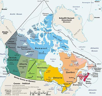
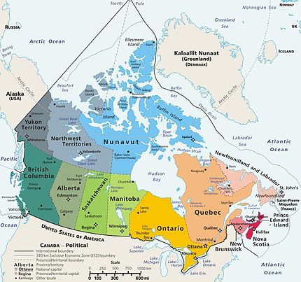
Module:Location map/data/CanadaGeo
| name | CanadaGeo | ||
|---|---|---|---|
| x | 43.337724969237172 - 2.056739941370653*($1 - 90.076056288799123)*sin(0.014911471311070*($2 - ($2 > 0)*360 + 94.820677904662404)) | ||
| y | 0.309016119058895 - 2.056739941370653*($1 - 90.076056288799123)*cos(0.014911471311070*($2 - ($2 > 0)*360 + 94.820677904662404)) | ||
| image | Canada_geopolitical_map_trim.jpg
| ||

| |||
Module:Location map/data/CanadaGeo is a location map definition used to overlay markers and labels on an equirectangular projection map of CanadaGeo. The markers are placed by latitude and longitude coordinates on the default map or a similar map image.
Usage
These definitions are used by the following templates when invoked with parameter "CanadaGeo":
{{Location map|CanadaGeo |...}}{{Location map many|CanadaGeo |...}}{{Location map+|CanadaGeo |...}}{{Location map~|CanadaGeo |...}}
Map definition
name = CanadaGeo- Name used in the default map caption
image = Canada_geopolitical_map_trim.jpg- The default map image, without "Image:" or "File:"
x = 43.337724969237172 - 2.056739941370653*($1 - 90.076056288799123)*sin(0.014911471311070*($2 - ($2 > 0)*360 + 94.820677904662404))- An expression to calculate a location on the map via its longitude; evaluates as 0 along the left edge and 100 along the right edge
y = 0.309016119058895 - 2.056739941370653*($1 - 90.076056288799123)*cos(0.014911471311070*($2 - ($2 > 0)*360 + 94.820677904662404))- An expression to calculate a location on the map via its latitude; evaluates as 0 along the top edge and 100 along the bottom edge
Examples using location map templates
Some common label background colors are: #CCCC55 for dim yellow,
- #44EE44 for lime green, #BBBBBB for gray,
- #44CCDD for light aqua, #DDDDDD for light gray (almost white),
- PaleGreen for pale green, PaleTurquoise, DarkOrange, etc.
- By default, the label is transparent overwriting the image.
For small lettering use label_size=80, for tiny words use 55. Note that the words in the label will wrap unless using "nbsp": DO NOT WRAP.
When specifying image "width=270" be sure to OMIT "px" (which causes the image to span the width of the screen) because "px" cannot (yet) be detected by the (new) MediaWiki language which processes those mapping templates.
See each specific mapping template for other parameters to pass.
Simple syntax
{{Location map|CanadaGeo|lat= |long=- |caption={{subst:PAGENAME}} in [[Canada]]}}
Multiple labels
{{Location map many
| CanadaGeo|
| caption = Vancouver, Quebec, Edmonton & Winnipeg
| lon_shift = 4.1
| label=Vancouver
  | label_size=70
  | background = <!--aqua-->#44CCDD
  | position=top<! left/right/bottom >
  | lat = 49.25  <!--40.6 to 92.5 -->
  | long= -123.1 <!--55.1 to 125.1W-->
  | mark=Green_pog.svg
  | marksize=10 <! default 8, 1=none >
| label2=Quebec City | label2_size=70
  | bg2 = DarkOrange
  | pos2= bottom <!or right/left/top >
  | lat2= 46.80 | long2 = -71.38
  | mark2=Blue_pog.svg
  | mark2size=10<! marker size (8) >
| label3=Alert | label3_size=70
  | bg3 = PaleGreen
  | pos3=right
  | lat3= 82.46 | long3= -62.50
  | mark3=Blue_pog.svg
  | mark3size=8
| label6=Edmonton
  | lat6 = 53.57 | long6 = -113.42
| label4=Winnipeg | label4_size=70
  | bg4 = SkyBlue
  | pos4 =left
  | lat4 = 49.88 | long4 = -97.13
  | mark4=Blue_pog.svg
  | mark4size=6
| label5=Churchill,_MB
  | lat5 = 58.76 | long5 = -94.12
  | bg5 = #77EE77
  | pos5 = top
  | mark5=Blue_pog.svg | mark5size=6
| width=430 <!--map width-->
| float=right <!--left/center--></nowiki>
}}
{{Location map many
| CanadaGeo|
| width=320 <!--omit "px"-->
| lon_shift = 4.1
| bottom= 41.3 | top= 91.1
| label=Quebec City
  | label_size=70 |pos=right
  | bg = DarkOrange
  | lat=46.48 | long= -71.38
  | mark=Blue_pog.svg
  | marksize=10
| label2=Yellowknife
  | label2_size=70
  | bg2=#DDDD44 | pos2=left
  | lat2=62.45|long2=-114.40
  | mark2=Blue_pog.svg
  | mark2size=10<!default:8>
| label3=Churchill,_MB
  | label3_size=70
  | bg3=#77EE77
  | pos3=right
  | lat3=58.76 |long3= -94.12
  | mark3=Blue_pog.svg
  | mark3size=8
| label4=Alert
  | bg4=PaleGreen | pos4=right  | label4_size=70
  | skew4=0.00005
  | lat4=82.46 | long4= -62.50
  | mark4=Blue_pog.svg | mark4size=8
| label5=ArcticCircle
  | bg5=#99CCFF   | pos5=top  | label5_size=70
  | skew5=0.00005
  | lat5= 66.5 | long5= -90
  | mark5=Blue_pog.svg | mark5size=8
| float=right <!--left/center-->
| caption = Quebec east, Yellowknife in northwest, Churchill (center), Alert (top)
}}
See also
Location map templates
- Template:Location map, to display one mark and label using latitude and longitude
- Template:Location map many, to display up to nine marks and labels
- Template:Location map+, to display an unlimited number of marks and labels
Creating new map definitions
return {
	name = 'CanadaGeo',
	image = 'Canada_geopolitical_map_trim.jpg',
	x = '43.337724969237172 - 2.056739941370653*($1 - 90.076056288799123)*sin(0.014911471311070*($2 - ($2 > 0)*360 + 94.820677904662404))',
	y = '0.309016119058895 - 2.056739941370653*($1 - 90.076056288799123)*cos(0.014911471311070*($2 - ($2 > 0)*360 + 94.820677904662404))'
}


