Spur, Texas
Spur, Texas | |
|---|---|
 | |
 Location of Spur, Texas | |
 | |
| Coordinates: 33°28′40″N 100°51′25″W / 33.47778°N 100.85694°W | |
| Country | United States |
| State | Texas |
| County | Dickens |
| Area | |
| • Total | 1.6 sq mi (4.2 km2) |
| • Land | 1.6 sq mi (4.2 km2) |
| • Water | 0.0 sq mi (0.0 km2) |
| Elevation | 2,287 ft (697 m) |
| Population (2010) | |
| • Total | 1,318 |
| • Density | 821/sq mi (316.8/km2) |
| Time zone | UTC-6 (Central (CST)) |
| • Summer (DST) | UTC-5 (CDT) |
| ZIP code | 79370 |
| Area code | 806 |
| FIPS code | 48-69848[1] |
| GNIS feature ID | 1369049[2] |
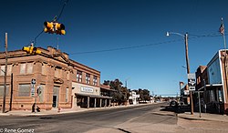
Spur is a city in Dickens County, Texas, United States. The population was 1,318 at the 2010 census,[3] up from 1,088 at the 2000 census. A city council resolution passed July 2014 proclaimed Spur the "nations’ first tiny house friendly town."
On October 9, 2009, Spur celebrated its centennial with the dedication of a Giant Spur sculpture. The Giant Spur was built by local welder John Grusendorf. The event, sponsored by the Dickens County Historical Commission, was held at Dyess Park off Texas State Highway 70.
On March 28, 2017 a traffic accident west of the city resulted in the deaths of 3 storm chasers after one vehicle disregarded a stop sign at highway speed: Kelley Williamson and Randy Yarnell, both from Cassville, Missouri, and Corbin Jaeger from Peoria, Arizona. Williamson ran through a stop sign at high speed and struck Jaeger on the drivers' side. All three men died instantly.
Geography
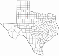
Spur is located in southern Dickens County at 33°28′40″N 100°51′25″W / 33.47778°N 100.85694°W (33.477650, -100.857018).[4] Texas Highway 70 passes through the city, leading north 11 miles (18 km) to Dickens, the county seat, and southeast 24 miles (39 km) to Jayton.
According to the United States Census Bureau, the city has a total area of 1.6 square miles (4.2 km2), all land.[3]
Climate
According to the Köppen Climate Classification system, Spur has a semi-arid climate, abbreviated "BSk" on climate maps.[5]
Demographics
| Census | Pop. | Note | %± |
|---|---|---|---|
| 1920 | 1,100 | — | |
| 1930 | 1,899 | 72.6% | |
| 1940 | 2,136 | 12.5% | |
| 1950 | 2,183 | 2.2% | |
| 1960 | 2,170 | −0.6% | |
| 1970 | 1,747 | −19.5% | |
| 1980 | 1,690 | −3.3% | |
| 1990 | 1,300 | −23.1% | |
| 2000 | 1,088 | −16.3% | |
| 2010 | 1,318 | 21.1% | |
| 2016 (est.) | 1,196 | [6] | −9.3% |
| U.S. Decennial Census[7] | |||
As of the census[1] of 2000, there were 1,088 people, 472 households, and 288 families residing in the city. The population density was 673.4 people per square mile (259.3/km²). There were 641 housing units at an average density of 396.7 per square mile (152.8/km²). The racial makeup of the city was 72.52% White, 3.40% African American, 0.83% Native American, 0.18% Asian, 0.37% Pacific Islander, 21.14% from other races, and 1.56% from two or more races. 31.25% of the population were Hispanic or Latino of any race.
There were 472 households out of which 22.5% had children under the age of 18 living with them, 47.5% were married couples living together, 10.6% had a female householder with no husband present, and 38.8% were non-families. 37.1% of all households were made up of individuals and 20.8% had someone living alone who was 65 years of age or older. The average household size was 2.22 and the average family size was 2.89.
In the city, the population was spread out with 22.9% under the age of 18, 6.1% from 18 to 24, 22.3% from 25 to 44, 23.4% from 45 to 64, and 25.3% who were 65 years of age or older. The median age was 44 years. For every 100 females there were 83.8 males. For every 100 females age 18 and over, there were 82.0 males.
The median income for a household in the city was $24,286, and the median income for a family was $32,772. Males had a median income of $25,972 versus $18,631 for females. The per capita income for the city was $14,601. 19.8% of the population and 16.2% of families were below the poverty line. 24.8% of those under the age of 18 and 21.7% of those 65 and older were living below the poverty line.
Education
The city of Spur is served by the Spur Independent School District.
Tiny Houses
Spur's regulations are friendly to tiny houses, so long as they have an adequate foundation and proper plumbing and electrical wiring installed.[8] House plans must be approved. Flush toilets are required as well as a wood or metal frame. In general, experimental strawbale houses, yurts, or underground houses are not permitted.[9]
Notable residents
- Marshall Applewhite (May 17, 1931 – March 26, 1997), the leader of the Heaven's Gate cult, was born in Spur. He died in the group's mass suicide of 1997.
- Raymond Beadle (1943-2014), a drag-racing driver and member of the Motorsports Hall of Fame of America, was born in Spur.
- Charles Weldon Cannon, a well-known maker of boots and saddles, lived in Spur from 1949 to 1964, when he relocated to Dickens.
- Aaron Latham, a Spur native, wrote the script of the 1980 film Urban Cowboy. In the story line, the protagonist, Bud Davis (played by John Travolta), is said to have been from Spur.
- Red McCombs (born 1927), a San Antonio businessman who owned the NBA's San Antonio Spurs and NFL's Minnesota Vikings, was born in Spur.
- William B. Mciver, a Spur student in the 1940s, wrote By Dead Reckoning, a book that includes chapters on the history of the Espuela Land and Cattle Company, the founding of Spur, and life on a cotton farm and dairy in Highway Community district of Dickens County.
Photo gallery
References
- ^ a b "American FactFinder". United States Census Bureau. Retrieved 2008-01-31.
- ^ "US Board on Geographic Names". United States Geological Survey. 2007-10-25. Retrieved 2008-01-31.
- ^ a b "Geographic Identifiers: 2010 Demographic Profile Data (G001): Spur city, Texas". American Factfinder. U.S. Census Bureau. Retrieved January 8, 2016.
- ^ "US Gazetteer files: 2010, 2000, and 1990". United States Census Bureau. 2011-02-12. Retrieved 2011-04-23.
- ^ "Climate Summary for Spur, Texas". Weatherbase. Retrieved 14 September 2014.
- ^ "Population and Housing Unit Estimates". Retrieved June 9, 2017.
- ^ "Census of Population and Housing". Census.gov. Retrieved June 4, 2015.
- ^ "WELCOME TO SPUR". spurfreedom.org. Spur, TX. Retrieved June 14, 2016.
Any tiny house that features wood or metal framing, flush toilets connected to city utilities and electrical work properly done, is welcome in Spur.
- ^ Lukas I. Alpert (June 13, 2016). "West Texas Town Finds 'Tiny House' Crowd a Bit Too Earthy Luring eco-conscious builders of 120-square-foot homes seemed like a great idea until plans for yurts, straw dwellings popped up; no anarchists, please". The Wall Street Journal. Retrieved June 14, 2016.
Spur has sold 60 abandoned lots for roughly $500 apiece, and about 20 "tiny housers" are expected to be moved in by the end of summer.


