Carondelet Reef
| Carondelet Reef | |
|---|---|
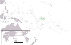
 Location of Phoenix Islands | |
| Summit depth | 1.8 metres |
| Location | |
| Location | central Pacific Ocean |
| Group | Phoenix Islands |
| Coordinates | 05°34′S 173°51′W / 5.567°S 173.850°W |
| Country | Kiribati |
| Geology | |
| Type | Reef |
| History | |
| Discovery date | 1898 |

Carondelet Reef is a horseshoe-shaped reef of the Phoenix Islands, also known as the Rawaki Islands, in the Republic of Kiribati. It is located 106 km southeast of Nikumaroro, at 05°34′S 173°51′W / 5.567°S 173.850°W, and has a least depth of 1.8 meters. It is reported to be approximately 1.5 km in length.[1] The sea occasionally breaks over it.
History and Name
Carondelet Reef was named for the American barque "Carondelet" of San Francisco, by her captain Wilder Farley Stetson (1849-1924) of Damariscotta, Maine. Stetson sighted the reef on August 31, 1898, on a voyage from Puget Sound to Adelaide, South Australia.[2]
The multiple positions of Winslow Reef, mentioned by Robert Louis Stevenson, may have been due to confusing the position of Carondelet Reef with Winslow Reef.
Status
The reef is part of the Phoenix Islands Protected Area as an underwater nature reserve.
See also
References
- ^ Mike Pearson; Jonathan Willis-Richards. "Islands of Kiribati". Archived from the original on 2006-12-31. Retrieved 2007-02-21.
{{cite web}}: Unknown parameter|deadurl=ignored (|url-status=suggested) (help) - ^ Dehner, Steve. "The Armchair Navigator I".
{{cite web}}: Cite has empty unknown parameter:|dead-url=(help)
External links
- Phoenix Islands Protected Area, Kiribati
- Oceandots at the Wayback Machine (archived December 23, 2010)
