
User talk:Viewfinder
|
Viewfinder is a shit dipper
Couldn't have put it better myself Kinggobbler 01:16, 2 December 2006 (UTC) The fucking dogs bollocks is I
There is already large amounts of uncited pro-Galloway material on his page, plus a long-running cabal of editors planted their by SWP who vigorously defend it. Or are you only interested in "anti" rather than "pro" stuff? Why is that better? I am trying to offer a little balance to the Galloway fan club. I read your work ethic on your front page, and I applaud it, but the reality is that far too many pages on WP have adulatory material and this is a much bigger problem than the anti vandals. It just seems less because it's less grating. Maybe you could relax a little on political pages and go with the flow on comment, politics is all about comment and if we stack every page with hundreds of cites they get unreadable. I note that the onus from you is always on the likes of me to cite, whereas flattering material can be uncited. MarkThomas 08:05, 18 September 2006 (UTC)
- WP:BLP makes it clear that negative material needs to be particularly thoroughly cited. I have no objection to your addition of anti-Galloway material, but it is essential that you cite reliable sources. If you do this, then I will defend your edits. There are plenty of right-wing leaning, anti Galloway material that is considered reliable. Uncited negative material about right wing public figures should be equally mercilessly deleted, and if you need help with this against "SWP" plantations, then let me know. Viewfinder 16:54, 18 September 2006 (UTC)
- I'm sure you're recent revert threat was directed at me, but in fact I was reverting numerous reversions of my original edit from some time ago. The Galloway praise of SH hardly needs citation for proof, it's been shown on every TV network in the world a zillion times. It can easily be cited if you really want to further break up the para flow on the initial section. I have added semiprotect to stop the newly created user harassment and called for a proper discussion repeatedly and been abused for it. MarkThomas 17:40, 19 September 2006 (UTC)
Please read WP:3RR, which states that no individual editor may perform a revert on a single article more than 3 times in 24 hours. It was enforced against me not long ago. Also the salutation of Saddam does not need to be stated in the article more than once. Viewfinder 17:47, 19 September 2006 (UTC)
OK, I understand this and I won't try any more reverts on it, at least for a while. :-) But it really gets exasperating that no proper discussion can apparently be had about the opening para of the Galloway article, given the widely celebrated and controversial nature and status of his Saddam-praise. I am convinced that it's placement way down the article is deliberate. MarkThomas 17:50, 19 September 2006 (UTC)
I see you've rm'ed the semiprotection on the grounds that they are all established users. How do you check how long someone has been a user please? For example, Sandy seems to have been a user for about 48 hours. MarkThomas 18:45, 19 September 2006 (UTC)
- Click on the user's name, then click on "user contributions". Both SandyDancer and Guy Hatton are established users. Viewfinder 19:02, 19 September 2006 (UTC)
- Puzzling then that neither of them rushed to rectify my changes as they so normally do. Perhaps they couldn't for some reason? MarkThomas 19:04, 19 September 2006 (UTC)
- Your most recent edit was much shorter, more appropriate for a summary so I decided not to revert it, but leave it toother editors to decide. But that does not imply that I endorse it. Although I have not checked thoroughly, I think SandyDancer is on his third revert but I do not think Guy Hatton is. Viewfinder 19:15, 19 September 2006 (UTC)
Not vandalism
- It was definitely not vandalism. When the image was replaced to Paine.jpg, it was thought to have been pointed to the same image as on Wikimedia Commons, and not to a different one. Peter O. (Talk) 23:07, 19 September 2006 (UTC)
- Ok, it was an accident. See your own talk page. Viewfinder 00:28, 20 September 2006 (UTC)
United Kingdom
Thanks for your attempts to be reasonable with the literature debate. Hopefully we'll get a decent section to replace the list at some point. Cordless Larry 18:59, 21 September 2006 (UTC)
Protection Template
Please note, that though I did not unprotect your page at all, it was never protected. I cleaned up a maintenance template {{sprotected}} that was on a page that did not have protection set. Placing that template on a page does not protect it. To request page protection, you can go to WP:RFPP. Although this is User: space, the page does not 'belong' to you, please see WP:USERPAGE for more information on userpages. If your page is under a heavy vandalism attack, you can request assistance at administrator intervention against vandalism. I hope this clears things up, if not please leave me another note. Thanks, — xaosflux Talk 01:18, 3 October 2006 (UTC)
- When I added the semi-protect template, the appropriate disabling message appeared, so I assumed that this was OK and that it was working. If the problem does re-occur then I will try RFPP or AIV. Viewfinder 01:37, 3 October 2006 (UTC)
- Only wiki sysops (admins) can place protection on a page; the template is just a notice to others. No worries though, — xaosflux Talk 01:47, 3 October 2006 (UTC)
Golan Heights
Please count the number of reverts. I Have not merely reverted but also added clarifications.
I am sorry for being insufficiently pro-Israel. I had thought Wikipedia aimed to be anti-elitist but you are rapidly showing me the error of my ways Aminaa
Your edits are still basically reverts. I will report you; admin can then decide whether or not to block you. Viewfinder 00:41, 12 October 2006 (UTC)
Not surprised; I should have expected as much from a bunch of rightwing white boys. Wikipedia as a notion is clearly dead. Aminaa
K2
I feel bad to read the article says it is in Kashmir instead of in Pakistan. Can you visit K2 using Kashmir or China visas. No. Then it is important to mention Pakistan in the beginning. I feel it is not necessary to even mention it is in Kashmir or near China but if you like to mention it then do not mention it in the start. --- ابراهيم 09:34, 13 October 2006 (UTC)
- See the K2 talk page and in particular the linked map. It is on the border with China. Viewfinder 09:36, 13 October 2006 (UTC)
- I have added my two cents on Talk:K2 and put in some minor changes to K2 itself, see those pages for more. In particular, yes, it is definitely on the border; not sure why the claim that you can't get there from the China side. Hopefully this is leading toward a (temporary!) stable state that is somewhat satisfactory. -- Spireguy 15:13, 13 October 2006 (UTC)
- Hi, I have given links for 1963 Pakistan china border agreement. Please see Spireguy page and help in resolving this dispute. I will be thankful. --- ابراهيم 15:26, 2 November 2006 (UTC)
List of mountains in Argentina
Hi! Since you seam to have a far better background on mountaineering than me, I wanted to ask you what do you think about the disposition of montains in the article List of mountains in Argentina, grouped by system. Also, I did it myself with my little knowledge on the subject, so it's bound to be really wrong; could you take a look at it? Thanks a lot, Mariano(t/c) 08:41, 24 October 2006 (UTC)
- My background is in topography, I am not a mountaineer and seldom hike outside Britain. Most of my knowledge of mountains comes from SRTM data, maps, and contacts who are mountaineers, including John Biggar, who runs Andes expeditions and has probably climbed more Andean summits than anyone else. I think your grouping by system is a good idea. There is no definitive way of doing this. At first sight, it would seem that there are too many mountains listed under Ojos before you get to Pissis, but I look at the systematics more carefully. Unfortunately listing mountains by countries is often up against the problem that international borders divide mountain systems which are not naturally divisible. The Argentina-Chile border is a prime example of this. Viewfinder 09:17, 24 October 2006 (UTC)
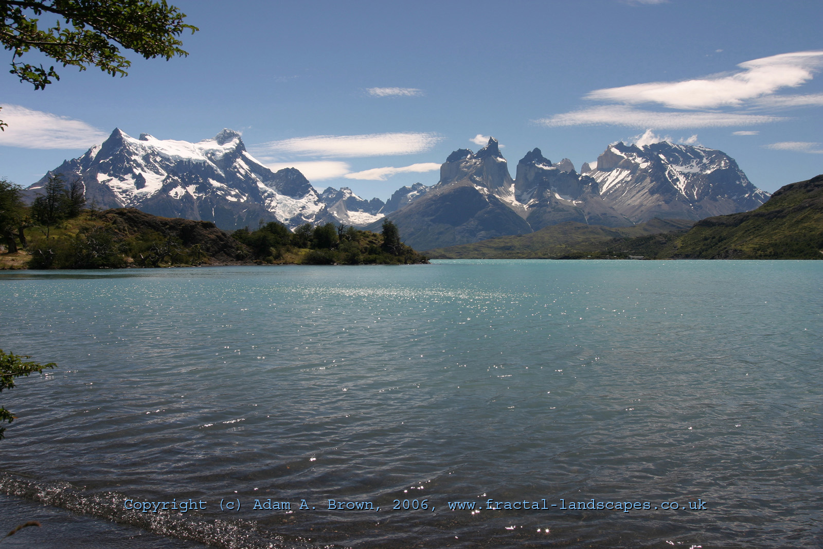
Paine Massif Heights
Hi, you asked about the possibility of establishing the height of the Cumbre Principal of Torres del Paine National Park. Unfortunately, from photographic evidence, it is very hard indeed to establish absolute heights, only relative heights. My calculations where only intended to establish, primarily, the relative heights of Paine Grande, the Cuerno Principal and the Torre Central.
My previous calculations neglected two variables, and I also had a 500 meter positional error in the viewpoint I took on the map. The height above sea-level of Lago Pehoe, and the curvature of the earth were also not accounted for. The curvature of the Earth admits at most a 25 meter error into the observed heights of those mountains from the Pehoe viewpoint. Assuming an adjusted height of 100m for Lago Pehoe accounts for both factors. We get 2360 for the Cuerno Principal and 2725 for the Torre Central. An additional calculation by the same method gives the relative height of Paine Chico as 2825. This relative height explains why the Torres are so effectively hidden. Anyone summiting any of the Torres would be surprised to find a higher mountain to their south. As for the absolute heights, it is impossible to guess without a reliable reference. Anyone with a GPS handset and about an hour of their time there could provide it, but unfortunately, its the other side of the world.
The calculations assume that Lago Pehoe is at 75 meters.
Cumbre Principal (Pixel Height 490, Distance 14.9, ht 3050) Cuerno Principal (Pixel Height 459, Distance 12.2, ht 2360) Torre Central (Pixel Height 361, Distance 18.0, ht 2725) Paine Chico (Pixel Height 438, Distance 15.4, ht 2825)
All heights are relative to an assumed height of 3050 for the Paine Grande. This may not be accurate, but I can't see any reason for supposing that the listed height for the Paine Chico is more or less accurate than that listed for Paine Grande. The greatest source of error is still likely to be any rotation of the image, in which case, the relative height of the Cuerno Principal would be twice as accurate as the relative height of Paine Chico. Incidentally, the other Peak of Mte Admirante Nieto is higher than Paine Chico..
I will quickly attempt to establish exact heights from the photo as well...
This is harder, because I need to guess the view direction. The perpendicular distance (in the plane of the projection) between the Cuerno Principal and the Cumbre Principal is 6.3 km, when measured at the distance of the Cumbre Principal. This occupies 997 pixels. Assuming both points are close to the view direction (not too far out), we get 1 pixel ~= 6.3 meters at that distance. This gives us an adjusted height for the Cumbre Principal of (2880 to 3480), subject to an error of +/-10%. So I believe the 3050 figure as being possible, but discount any estimate below the lower range of that. For small changes to the estimated height of the Cumbre Principal, the other heights can be assumed to scale linearly.
-- The Ostrich
- The reason for supposing that the listed height for the Almirante Nieto is more accurate is that one of its routes is the easiest of the Paine Massif. Contrary, to reach the summit of Paine Grande is perhaps the hardest climb in the massif (only two ascents). Jespinos 23:14, 27 November 2006 (UTC)
Your photograph is excellent, and I will repeat my calculations based on your photograph and viewpoint. This will take a while, but I initially note that you agree with me that there is a massive error in the relative height of Paine Chico/Admirante Nieto and Cuerno Principal implied by the elevations shown on current mapping. Establishing the absolute heights is more difficult, but should be possible. But the angle of vision on your photograph is quite wide; I think that this can create significant distortion, although you probably know more about this than I do. Viewfinder 17:06, 27 November 2006 (UTC)
One other quick point of information, the height of Lake Pehoe is 34 metres; this is supported by SRTM data and official Chilean mapping. Viewfinder 17:13, 27 November 2006 (UTC)
Before I carry out further calculations, please could you send me the full sized version of your photograph, so that I can verify your pixel claims. The pixel heights you give suggest that your 1600x1067 version is smaller than your original. Viewfinder 17:35, 27 November 2006 (UTC)
Yeah. My email is a&dam_a_brow&n@hotma&il.com without the &s. If you drop me a mail, I'll send you the larger version. But please understand that it isn't for common distribution. As for the field of view, that is the primary source of the error in the absolute height calculation, but the relative height calculations don't have any error from this, provided that a) the photograph is indeed a planar projection and b) that the vertical centre of the photograph is close to horizontal. If a) were not true, it would create image distortion, so it is pretty much given. as for b, the complete photograph is actually looking down by 55 pixels out of the total span of 2048. This means that vertical lines will slope ever so slightly towards the centre as they rise, but it is pretty negligible (tan of a small angle close to 0). I've also established, based on the horizon line of the lake, that the image rotation is less than 1 in 435, which eliminates that source of error.
The actual position from which the photo was taken is not the hotel explora, but the pehoe camp site, about 500 - 1000 meters to the north of that. As for the error introduced by the height of lago pehoe, it only affects the proportion of the height that scales. This means that if Pehoe is at 25 meters, the error is the scaling of the extra 50 meters, which produces a relative error of about 2% in the relative heights, or 25m. Since the other sources of error are compatible with this figure, you can neglect it. The curvature of the Earth results in the height for the Torres being higher than my calculations by something like 20 m, but the other mountains are pretty much unaffected, being at approximately the same range, and nearer.
-- The Ostrich
ps: how do you date tag your contribution?
You can sign and date tag your contributions with four tildes. A quick point: you give a range of 2880-3480, assuming 10% error, but I make 490 x 6.3 = 3087, so should not your range be nearer to 2780-3380? Viewfinder 19:42, 27 November 2006 (UTC)
Nope. There was a +100 in there. You see, firstly the viewpoint was assumed at 75 meters above sea level, and secondly, the curvature of the Earth results in the bottom 25 meters being below the horizon. However... Since Pehoe is actually at 25 meters above sea level, and since the curvature of the Earth accounts for 17 meters not 25 as I thought, this makes the difference 40 meters. So the actual figure from the calculation should be 3130. But this will under normal circumstances be under-estimated by the downward viewpoint of the camera, and over-estimated by the deviation from the centre of projection, hence the error. Also, my measurement of the perpendicular distance had to assume a view direction that may not have been very close to the actual view direction. The Ostrich 19:46, 27 November 2006 (UTC)
- The above discussion continued offline. It was agreed that there was another error source, Paine Grande is not more than 14.3 km (14.1 km according to my calculation) from the photo source. It was further agreed that the photograph suggested that Paine Grande is 2,900m high, but that there is a 10% error margin. The photograph that we are discussing (Paine Grande is on the left) suggests a higher Paine Grande summit than other photographs (e.g. this one) that I have studied. I hope that an accurate survey will resolve this question soon; geometric analysis of photographs is evidently not accurate, especially if the angle of vision is wide. Viewfinder 13:02, 28 November 2006 (UTC)
Thank you
Thanks very much for reverting the vandalism (link) on my user talk page, I appreciate it. Gasheadsteve 18:49, 26 November 2006 (UTC)