Nagar Valley
This article needs additional citations for verification. (December 2018) |
Nagar Valley نگر | |
|---|---|
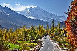
 The 7,788 m (25,551 ft) tall Rakaposhi as seen from the Nagar Valley | |
| Coordinates: 36°15′55″N 74°42′49″E / 36.2652548°N 74.7135025°E[1] | |
| Country | Pakistan |
| Region | Gilgit Baltistan |
| District | Nagar District |
Nagar Valley (Template:Lang-ur) also known as formerly princely state, is one of the ten districts of Gilgit Baltistan, Pakistan.[2][3] The valley is along the Karakoram Highway on the way north from Gilgit main city.The valley is home to many high mountain peaks including Rakaposhi (7788)m), Diran Peak (7265m), Golden Peak and Rush Peak. 24 villages exist today in the whole district named as Bar, Budelas, Chaprot, Chalt, Sikanderabad, Jafferabad, Nilt, Thol, Masot, Ghulmat, Yal, Pissan, Minapin, Miachar, Dadimal, Tashot, Pheker, Hakuchar, Shayar, Askurdas, Sumayar, Nagar Khaas, Hoper and Hisper[4]. But the most famous touristic spots are Minapin, Ghulmat (also known as Rakaposhi view point), Chalt, and Hoper. Burushaski and Shina languages are spoken in the valley.[2] Rush Lake, the highest alpine lake of Pakistan and the 27th highest lake in the world also lies in this valley.
History
Geography
The whole region is hilly and mountainous topographically, but every part of the valley is easily accessible. The Karakoram mountain range covers the whole region, of which Rakaposhi is one part. Of the total area of Nagar valley, 90% is above 3,000 meters above sea level and 30% is 5,000 meters above sea level.[4]
Famous Peaks
Famous peaks in the region are:
Rakaposhi, Diran, Golden Peak and Miachar Peak (also known as Miar Shekar)
Glaciers
Hoper Glacier, Hisper Glacier, Barpu Glacier, Minapin Glacier, Pissan Glacier.
Tourism
Hotels
Trekking
Climbling
Valleys nearby
References
- ^ "Nagar on map". Google Maps. Retrieved 15 September 2019.
- ^ a b "Nagar Valley". visitgilgitbaltistan.gov.pk. Retrieved 15 September 2019.
- ^ "Nagar Valley, Gilgit Baltistan, Pakistan". myadventure.pk. Retrieved 7 November 2018.
- ^ a b Spies, Michael (2019). Norther Pakistan: High Mountain Farming and Changing Socionatures. Lahore Pakistan: Vanguard books. p. 63. ISBN 9789694026091.
General
- Leitner, G. W. (1893): Dardistan in 1866, 1886 and 1893: Being An Account of the History, Religions, Customs, Legends, Fables and Songs of Gilgit, Chilas, Kandia (Gabrial) Yasin, Chitral, Hunza, Nagyr and other parts of the Hindukush, as also a supplement to the second edition of The Hunza and Nagyr Handbook. And An Epitome of Part III of the author’s “The Languages and Races of Dardistan.” First Reprint 1978. Manjusri Publishing House, New Delhi.
External links

