
Šar Mountains: Difference between revisions
Undid revision 241880133 by 70.80.93.11 (talk) rvv. |
|||
| Line 4: | Line 4: | ||
|name=Šar Mountain |
|name=Šar Mountain |
||
|image= Mali i Sharrit.jpg |
|image= Mali i Sharrit.jpg |
||
|image_caption= Šar Mountain from |
|image_caption= Šar Mountain from Osljak in Serbia |
||
|region_type= |
|region_type= |
||
|region=Balkans |
|region=Balkans |
||
|region1= |
|region1= |
||
|border=| {{ |
|border=| {{SRB}}, {{MKD}}, and {{ALB}} |
||
|highest=[[Titov Vrv]] |
|highest=[[Titov Vrv]] |
||
|highest_elevation= 2747 |
|highest_elevation= 2747 |
||
| Line 16: | Line 16: | ||
The '''Šar Mountain''' ({{lang-sq|Malet e Sharrit}}, {{lang-mk|{{audio|Mk-Shar Planina.ogg|Шар Планина}}}}, {{lang-sr|Шар Планина/Šar planina}}) is a [[mountain range]] that extends from southern [[ |
The '''Šar Mountain''' ({{lang-sq|Malet e Sharrit}}, {{lang-mk|{{audio|Mk-Shar Planina.ogg|Шар Планина}}}}, {{lang-sr|Шар Планина/Šar planina}}) is a [[mountain range]] that extends from southern [[Serbia]] and the northwest of the [[Republic of Macedonia]] to northeastern [[Albania]]. |
||
==Geographical characteristics== |
==Geographical characteristics== |
||
[[Image:Kosovan Mountain.jpg|thumb|200px|right|Ljuboten and part of the Šar Mountain as seen from |
[[Image:Kosovan Mountain.jpg|thumb|200px|right|Ljuboten and part of the Šar Mountain as seen from Serbia]] |
||
[[Image:Šar Mountain, Macedonia.jpg|thumb|right|200px|Šar Mountain in [[Republic of Macedonia|Macedonia]]]] |
[[Image:Šar Mountain, Macedonia.jpg|thumb|right|200px|Šar Mountain in [[Republic of Macedonia|Macedonia]]]] |
||
The Šar Mountain has a total area of 1600km. 56,25% of that area is in the Republic of Macedonia, 43.12% in |
The Šar Mountain has a total area of 1600km. 56,25% of that area is in the Republic of Macedonia, 43.12% in Serbia, and 0,63% in Albania.<ref>''Rista Nikolić: "Glacijacija Šar Planine i Koraba“, Beograd, 1912 godina''.</ref> There are three plains Sirinic, Vraca (Šar Mountain)|Vraca and Rudoka.<ref>''Šar Planina, Živko Stefanovski, Napredok- Tetovo''</ref> |
||
The system is about 80 [[kilometer]]s long and 10-20 kilometres wide. It includes several high peaks: |
The system is about 80 [[kilometer]]s long and 10-20 kilometres wide. It includes several high peaks: |
||
* [[Titov Vrv]] (2747 m), the highest peak |
* [[Titov Vrv]] (2747 m), the highest peak |
||
| Line 40: | Line 40: | ||
Vegetation on the mountains includes [[agriculture|crops]] up to around 1000 [[metre|meters]], [[forest]]s up to 1700 meters, and above that lie high [[pasture]]s which encompass around 550 [[square kilometre]]s. The Šar Mountains are the largest compact area covered with pastures on the European [[continent]]. They are most known as the origin of the [[dog breed]] [[Šarplaninac]], which was bred on these pastures. On some days the Šar Mountains can be seen from [[Pristina]] which is many kilometres away. Ljuboten (the nearest peak to Pristina) stands out the best. |
Vegetation on the mountains includes [[agriculture|crops]] up to around 1000 [[metre|meters]], [[forest]]s up to 1700 meters, and above that lie high [[pasture]]s which encompass around 550 [[square kilometre]]s. The Šar Mountains are the largest compact area covered with pastures on the European [[continent]]. They are most known as the origin of the [[dog breed]] [[Šarplaninac]], which was bred on these pastures. On some days the Šar Mountains can be seen from [[Pristina]] which is many kilometres away. Ljuboten (the nearest peak to Pristina) stands out the best. |
||
== Šar Mountain in |
== Šar Mountain in Serbia== |
||
[[Image:Sharr Mountain.jpg|240px|thumb|left|Panoramic view of some of the Šar Mountain in |
[[Image:Sharr Mountain.jpg|240px|thumb|left|Panoramic view of some of the Šar Mountain in Serbia]] |
||
[[Image:Lake in Sharr Mountain.jpg|220px|thumb|right|One of the many, many lakes in the |
[[Image:Lake in Sharr Mountain.jpg|220px|thumb|right|One of the many, many lakes in the Serbian part of the Šar Mountain]] |
||
The Šar Mountain is located in the south- |
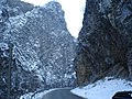
The Šar Mountain is located in the south-west of Serbia, where 43.12% of it is located. Many lakes are found on the Serbian part of the Sharr Mountain especially south of the village of [[Sharr]]. [[Brezovica]] is a ski resort with an elevation of 900m - 2,500m above sea level, it is located north-east of the mountain. [[Ljuboten]] and the mountain of [[Skopska Crna Gora]] create [[Kačanik Gorge]] in Serbia. The Sharr Mountain is split by [[Nerodimlje Mountain]] by the [[Sirinić Valley]]. Villages and towns that are found near the mountain are: |
||
*[[Prizren]] |
*[[Prizren]] |
||
| Line 75: | Line 75: | ||
}} |
}} |
||
The Šar National Park is in the territory of [[ |
The Šar National Park is in the territory of [[Serbia]], and spreads on 380 square kilometres, on the northern slopes of the Šar Mountains. What this national park boasts in particular are the endemic relict [[Macedonian Pine]] and white-bark pine, as well as the Alpine rose. As for game, this is the habitat of the [[eurasian lynx|lynx]], [[brown bear|bear]], [[chamois]], [[eurasian wolf|wolf]], [[roe deer]], [[wild boar]] and other species. |
||
== See also == |
== See also == |
||
Revision as of 03:08, 30 September 2008
The Šar Mountain (Albanian: Malet e Sharrit, Macedonian: ⓘ, Serbian: Шар Планина/Šar planina) is a mountain range that extends from southern Serbia and the northwest of the Republic of Macedonia to northeastern Albania.
Geographical characteristics

The Šar Mountain has a total area of 1600km. 56,25% of that area is in the Republic of Macedonia, 43.12% in Serbia, and 0,63% in Albania.[1] There are three plains Sirinic, Vraca (Šar Mountain)|Vraca and Rudoka.[2] The system is about 80 kilometers long and 10-20 kilometres wide. It includes several high peaks:
- Titov Vrv (2747 m), the highest peak
- Mal Turčin (2702 m)
- Borislavec (2662 m)
- Bistër (2651 m)
- Rudoka (2610 m)
- Maja e Zezë (2585 m)
- Vracë (2582 m)
- Kobilicë (2528 m)
- Piribeg (2524 m)
- Ljuboten (2498 m)
- Gemitash (2183 m)
The Šar Mountains extend to Mount Korab (2764 m) in the southwest, and pass into northeastern Albania.
Vegetation on the mountains includes crops up to around 1000 meters, forests up to 1700 meters, and above that lie high pastures which encompass around 550 square kilometres. The Šar Mountains are the largest compact area covered with pastures on the European continent. They are most known as the origin of the dog breed Šarplaninac, which was bred on these pastures. On some days the Šar Mountains can be seen from Pristina which is many kilometres away. Ljuboten (the nearest peak to Pristina) stands out the best.
Šar Mountain in Serbia
The Šar Mountain is located in the south-west of Serbia, where 43.12% of it is located. Many lakes are found on the Serbian part of the Sharr Mountain especially south of the village of Sharr. Brezovica is a ski resort with an elevation of 900m - 2,500m above sea level, it is located north-east of the mountain. Ljuboten and the mountain of Skopska Crna Gora create Kačanik Gorge in Serbia. The Sharr Mountain is split by Nerodimlje Mountain by the Sirinić Valley. Villages and towns that are found near the mountain are:
National Park
| Šar Mountain National Park | |
|---|---|
| Nearest city | Štrpce |
| Area | 390 km² |
| Established | 1986 |
The Šar National Park is in the territory of Serbia, and spreads on 380 square kilometres, on the northern slopes of the Šar Mountains. What this national park boasts in particular are the endemic relict Macedonian Pine and white-bark pine, as well as the Alpine rose. As for game, this is the habitat of the lynx, bear, chamois, wolf, roe deer, wild boar and other species.
See also
References
Gallery
-
 Šar Mountains
 -
 Šar Mountains
 -
 Šar Mountains


