
Aktove canyon
This article needs additional citations for verification. (June 2021) |
| Aktove canyon | |
|---|---|
.jpg) | |
  | |
| Naming | |
| Native name | Актівський канйон (Ukrainian) |
| Geography | |
| State | |
| Region | Mykolaiv Oblast |
| Coordinates | 47°42′40″N 31°28′34″E / 47.711°N 31.476°E |
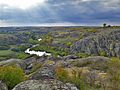
Aktove Canyon is a canyon near the Aktove village, on the Mertvovod river in the Voznesensk Raion of Mykolaiv Oblast of Ukraine. It is a part of the regional landscape park Granite-steppe lands of Buh. It is also a well-known place of pilgrimage. In the past it was a separate reserve "Aktove".[1][2]
Aktove Canyon consists of ancient weathered granite, cut by Mertvovid river on the depth of more than 50 meters. Area of the canyon outreaches 250 hectares. Being a unique complex of granite rocks, boulders and water/steppe ecosystems, canyon is located on one of the oldest parts of Eurasian land.[3]
The canyon is a part of the Bug Gard National Nature Park and the regional land park Granite-steppe lands of Buh.
Gallery[edit]
-
 Aktove Canyon
 -
 Aktove Canyon, Trikraty
 -
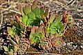 Flora in Aktove Canyon
 -
 Canyon in 2014
 -
 Canyon in 2017
 -
 Canyon in Autumn 2016


References[edit]
- ^ "Актівський каньйон - Гранд Каньйон по українськи". ozi.pp.ua. Retrieved 2021-06-02.
- ^ Давиденко В.М. ISBN 966-7458-53-9.
{{cite book}}: Missing or empty|title=(help) - ^ "АКТОВСЬКИЙ КАНЬЙОН | Миколаївська обласна рада". www.mk-oblrada.gov.ua. Retrieved 2021-06-02.