Caherboshina
Caherboshina
Cathair Bó Sine | |
|---|---|
Townland | |
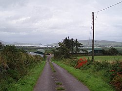
 Farmland and landscape at Caherboshina | |
| Coordinates: 52°08′43″N 10°20′16″W / 52.1453°N 10.3378°W | |
| Country | Ireland |
| Province | Munster |
| County | County Kerry |
| Area | |
| • Total | 1.8 km2 (0.7 sq mi) |
| Time zone | UTC+0 (WET) |
| • Summer (DST) | UTC-1 (IST (WEST)) |
| Irish Grid Reference | Q401030 |
Caherboshina (Irish: Cathair Bó Sine)[2] is a townland situated approximately 4 kilometres from Dingle (Daingean Uí Chúis) in County Kerry, Ireland.[3] Its position lies at the almost latitudinal centre of Ireland's most westerly land-mass, Corcha Dhuibhne (the Dingle Peninsula).[citation needed]
References[edit]
- ^ "Caherboshina Townland, Co. Kerry". townlands.ie. Retrieved 25 December 2020.
- ^ "Cathair Bó Sine / Caherboshina". logainm.ie. Irish Placenames Commission. Retrieved 25 December 2020.
- ^ General Alphabetical Index to the Townlands and Towns, Parishes, and Baronies of Ireland: Based on the Census of Ireland for the Year 1851, Volume 8. 1984. p. 182. ISBN 9780806310527.


