
Cyclone, Pennsylvania
Cyclone | |
|---|---|
| Nickname: Hilltop | |
 Cyclone Location within the state of Pennsylvania | |
| Coordinates: 41°49′56″N 78°35′9″W / 41.83222°N 78.58583°W | |
| Country | United States |
| State | Pennsylvania |
| County | McKean |
| Elevation | 2,198 ft (670 m) |
| Time zone | UTC-5 (Eastern (EST)) |
| • Summer (DST) | UTC-4 (EDT) |
| ZIP code | 16726[1] |
| Area code | 814 |
| GNIS feature ID | 1172875[2] |
Cyclone is an unincorporated community in McKean County, Pennsylvania, United States.
The community was so named on account of a cyclone (tornado) which struck the area.[3]
References[edit]
- ^ "Cyclone ZIP Code". zipdatamaps.com. 2022. Retrieved November 11, 2022.
- ^ U.S. Geological Survey Geographic Names Information System: Cyclone, Pennsylvania
- ^ Moyer, Armond; Moyer, Winifred (1958). The origins of unusual place-names. Keystone Pub. Associates. p. 30.
Municipalities and communities of McKean County, Pennsylvania, United States | ||
|---|---|---|
| City | 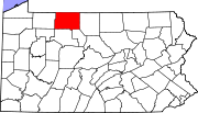 | |
| Boroughs | ||
| Townships | ||
| CDPs | ||
| Unincorporated communities | ||