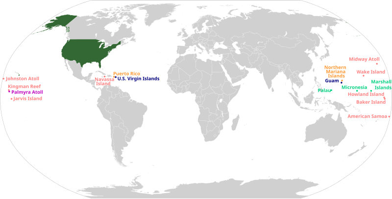
File:US insular areas.svg

Size of this PNG preview of this SVG file: 800 × 406 pixels. Other resolutions: 320 × 162 pixels | 640 × 325 pixels | 1,024 × 520 pixels | 1,280 × 650 pixels | 2,560 × 1,300 pixels | 2,754 × 1,398 pixels.
Original file (SVG file, nominally 2,754 × 1,398 pixels, file size: 1.12 MB)
File history
Click on a date/time to view the file as it appeared at that time.
| Date/Time | Thumbnail | Dimensions | User | Comment | |
|---|---|---|---|---|---|
| 08:22, 5 January 2020 |  | 1,474 × 628 (691 KB) | AndreyKva | Optimized using SVGOMG. | |
| 02:53, 18 August 2019 |  | 1,474 × 628 (1.94 MB) | BamZ412 | Reverted to version as of 05:23, 13 June 2019 (UTC) | |
| 05:28, 13 June 2019 |  | 1,474 × 628 (1.94 MB) | Koavf | And it was also extra-bold for some reason. | |
| 05:23, 13 June 2019 |  | 1,474 × 628 (1.94 MB) | Koavf | Why was only Jarvis Island in Arial Black??? Upload won't work, so I removed the script as well. | |
| 13:54, 12 July 2016 |  | 1,474 × 628 (2.1 MB) | Golbez | Fixed spelling of Mariana | |
| 22:13, 30 December 2014 |  | 1,474 × 628 (2.1 MB) | Master of Time | Fixed spelling of "Samoa" | |
| 05:34, 21 December 2014 |  | 1,474 × 628 (2.1 MB) | Mark Miller | Text faded | |
| 05:31, 21 December 2014 |  | 1,474 × 628 (2.1 MB) | Mark Miller | some missing elements | |
| 05:04, 21 December 2014 |  | 1,474 × 628 (2.1 MB) | Mark Miller | Fixed accidental cropping | |
| 04:52, 21 December 2014 |  | 1,401 × 632 (2.1 MB) | Mark Miller | User created page with UploadWizard |
File usage
The following pages on the English Wikipedia use this file (pages on other projects are not listed):
- 51st state
- Historical regions of the United States
- Insular area
- Lists of American universities and colleges
- Outline of the United States
- Territories of the United States
- U.S. territorial sovereignty
- United States
- Talk:List of largest empires/Archive 2
- Talk:List of states and territories of the United States
- Talk:United States/Archive 37
- Talk:United States/Archive 81
- User:0x270F/sandbox
- User:44Nifty/sandbox
- User:Arrate.catarain/Sandbox/Infoboxes/Place
- User:Buaidh
- User:Buaidh/sandbox
- User:Callejandrea/Sandbox/Infobox/Country
- User:CaptainElena/sandbox
- User:Dangerous-Boy
- User:Drabdullayev17/sandbox
- User:Est. 2021/UBX-WP/to-do/chaos
- User:Estibalizdelgado/sandbox/Infobox/Country
- User:Garaziarana/Sandbox/Infobox/Country
- User:Getaway Car/vinceroyalty
- User:Gorkagomez87/sandbox/Infobox/Country
- User:Jasper0333/sandbox
- User:Jonnguy2016/sandbox
- User:Laura G.Cabriada/sandbox/Infobox/Place
- User:NiklawskiMSTM/Iodni zad
- User:OKAnotherAccount/sandbox
- User:PMK2000/sandbox/USA
- User:Paul.deprado/Infobox/Country
- User:Paul.deprado/sandbox/Infobox/Country
- User:Paulabente/sandbox/Infobox/Country
- User:Ryantree/Userboxes
- User:Simple User of Something Something Something/sandbox
- User:SmallNomoAlt/New sandbox
- User:Stephen100002/sandbox
- User:SteveL1990/sandbox
- User:TheSaint250/sandbox
- User:Tomical01/sandbox
- User:Vimicius/sandbox
- User:XanUltra
- User talk:Buaidh/Archive 2018
- Wikipedia:Userboxes/WikiProjects/Regional/10
- Wikipedia:Userboxes/WikiProjects/United States
- Wikipedia:Userboxes/WikiProjects/alphabetical/28
- Wikipedia:WikiProject United States/userbox templates
- Wikipedia:WikiProject United States Territories
- Template:Portal/doc/all
- Template:User United States Territories/cat
- Template:User WP United States Territories
- Template:User WP United States Territories/doc
- Template:User in United States Territories
- Template:User in United States Territories/doc
- Template:User in United States Territories/doc1
- Template:User interest United States Territories
- Template:User interest United States Territories/doc
- Category:WikiProject United States Territories participants
- Category:Wikipedians interested in the territories of the United States
Global file usage
The following other wikis use this file:
- Usage on af.wikipedia.org
- Usage on ar.wikipedia.org
- Usage on az.wikipedia.org
- Usage on ban.wikipedia.org
- Usage on ba.wikipedia.org
- Usage on bg.wikipedia.org
- Usage on bh.wikipedia.org
- Usage on bjn.wikipedia.org
- Usage on bn.wikipedia.org
- Usage on bs.wikipedia.org
- Usage on ca.wikipedia.org
- Usage on cs.wikipedia.org
- Usage on da.wikipedia.org
- Usage on en.wikiquote.org
- Usage on en.wikiversity.org
- Usage on en.wiktionary.org
- Usage on eo.wikipedia.org
- Usage on es.wikipedia.org
- Usage on es.wiktionary.org
- Usage on eu.wikipedia.org
- Usage on fa.wikipedia.org
- Usage on fi.wikipedia.org
- Usage on fo.wikipedia.org
- Usage on fr.wikipedia.org
- Usage on ga.wikipedia.org
- Usage on gu.wikipedia.org
- Usage on he.wikipedia.org
- Usage on hr.wikipedia.org
- Usage on id.wikipedia.org
- Usage on incubator.wikimedia.org
View more global usage of this file.
