
Inwangsan: Difference between revisions
m update gallery center, replaced: <center><gallery> → <gallery>, </gallery></center> → </gallery>, <gallery> → <gallery class="center"> using AWB |
No edit summary |
||
| Line 2: | Line 2: | ||
| name = Inwangsan |
| name = Inwangsan |
||
| photo = Korea-Seoul-Inwangsan-01.jpg |
| photo = Korea-Seoul-Inwangsan-01.jpg |
||
| photo_size = 280 |
|||
| photo_caption = |
| photo_caption = |
||
{{Location map | South Korea | |
|||
| AlternativeMap = South Korea physical map.svg |
|||
| width = 273 |
|||
| float = center |
|||
| relief = yes |
|||
| caption = Location |
|||
| alt = Map of Inwangsan in South Korea |
|||
| label = Inwangsan |
|||
| lat_deg = 37.58495 |
|||
| lon_deg = 126.95930555555556 |
|||
}} |
|||
| elevation_m = 338 |
| elevation_m = 338 |
||
| elevation_ref = |
| elevation_ref = |
||
| |
| prominence_m = |
||
| prominence_ref = |
|||
| location = [[South Korea]] |
| location = [[South Korea]] |
||
| range = |
| range = |
||
| ⚫ | |||
| coordinates = |
|||
| topo = |
| topo = |
||
| type = |
| type = |
||
| Line 14: | Line 27: | ||
| last_eruption = |
| last_eruption = |
||
| first_ascent = |
| first_ascent = |
||
| easiest_route = |
| easiest_route = [[Gyeongbokgung Station]] |
||
}} |
}} |
||
{{Infobox Korean name/Mountain |
{{Infobox Korean name/Mountain |
||
| Line 53: | Line 68: | ||
* {{ko icon}} [http://www.hani.co.kr/arti/culture/travel/177495.html Travel to Inwangsan] |
* {{ko icon}} [http://www.hani.co.kr/arti/culture/travel/177495.html Travel to Inwangsan] |
||
| ⚫ | |||
[[Category:Jongno District]] |
[[Category:Jongno District]] |
||
Revision as of 10:01, 19 February 2015
| Inwangsan | |
|---|---|
  Inwangsan Location | |
| Highest point | |
| Elevation | 338 m (1,109 ft) |
| Coordinates | 37°35′06″N 126°57′33″E / 37.58500°N 126.95917°E |
| Geography | |
| Location | South Korea |
| Climbing | |
| Easiest route | Gyeongbokgung Station |
| Korean name | |
| Hangul | 인왕산 |
|---|---|
| Hanja | |
| Revised Romanization | Inwangsan |
| McCune–Reischauer | Inwangsan |
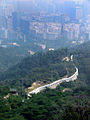
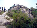
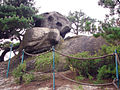
Inwangsan is a mountain with a height of 338 meters, located in Jongno-gu and Hongje-dong, Seodaemun-gu, central areas of Seoul, South Korea.[1] The name literally means "mountain of generous king" in Korean. The mountain covers an area of 1,086,696.50㎡ and has many huge granite peaks which distinguish it from other mountains in Seoul. Each rock is named after its characteristic form, such as gicha bawi (기차바위, train rock), chima bawi (치마바위 skirt rock), iseul bawi (이슬바위 dew rock), moja bawi (모자바위 hat rock), and jiryungii bawi (지렁이바위 worm rock).[2]
Inwangsan is famous for its view, so many painters depicted the mountain in their works such as Jeong Seon's Inwang jesaekdo. The Fortress Wall of Seoul surrounds the mountain in which Inwangsa temple and Guksadang shrine are located as well.[3]
Gallery
-
 Fort wall along Inwangsan in Seoul
 -
 Steps and fort wall on Inwangsan in Seoul
 -
 Fort wall on Inwangsan overlooking Seoul
 -
 Near the peak of Inwangsan in Seoul
 -
 On the top of Inwangsan in Seoul
 -
 Fort wall reconstruction on Inwangsan in Seoul
 -
 Remaining vigilant on Inwangsan in Seoul


See also
References
- ^ 인왕산 仁王山 (in Korean). Doosan Encyber. Retrieved 2008-05-05.
- ^ Mount Inwang, Seoul - IgoUgo Reviews
- ^ 인왕산 공원 (in Korean). The official site of the Seoul Metropolitan Government. Retrieved 2008-05-05. [dead link]