
Mikołajki: Difference between revisions
add info |
HerkusMonte (talk | contribs) →History: background |
||
| Line 46: | Line 46: | ||
Mikołajki is an old [[Masuria]]n church town first documented as Nickelsdorf (Sankt Niklas) in 1444 and Niklasdorf in 1493. The name refers to [[Saint Nicholas]] (''Mikołaj'' in Polish).<ref name=Czopek>{{cite web|url=http://ou.unideb.hu/onomural/kotetek/ou8/12czopek.pdf|title=Geographical Names Deriving from Saints’ Names (Patrocinia) in Poland |first=Barbara| last= Czopek-Kopciuch |page=231| format=PDF}}</ref><ref name=Bednarz>{{cite book |title=Fernes nahes Land |first=Klaus | last=Bednarz|authorlink=Klaus Bednarz|publisher =Hoffmann und Campe |year=1996|ISBN=3-455-11059-2|page=30 |language=German}}</ref> It was part of the [[State of the Teutonic Order]] and, from 1525 on, the [[Duchy of Prussia]]. Similar to all of [[Masuria]], it was mainly inhabited by [[Poles]], hailing from nearby [[Masovia]]. In 1539 the inhabitants of Nikokaiken were almost entirely [[Poles]].<ref name=sgk>''Słownik geograficzny Królestwa Polskiego i innych krajów słowiańskich'', Tom VI, Warszawa, 1885, p. 400 (in Polish)</ref> First Protestant pastors were mentioned in 1552.<ref name=sgk/> The settlement, now within the [[Kingdom of Prussia]], grew during the 18th century, receiving its [[town privileges]] as Nikolaiken in 1726. Because of its location on [[Śniardwy]], the fishery of Nikolaiken ensured continued prosperity; the [[Coregonus|whitefish]] of the region were especially popular throughout the province of [[East Prussia]]. |
Mikołajki is an old [[Masuria]]n church town first documented as Nickelsdorf (Sankt Niklas) in 1444 and Niklasdorf in 1493. The name refers to [[Saint Nicholas]] (''Mikołaj'' in Polish).<ref name=Czopek>{{cite web|url=http://ou.unideb.hu/onomural/kotetek/ou8/12czopek.pdf|title=Geographical Names Deriving from Saints’ Names (Patrocinia) in Poland |first=Barbara| last= Czopek-Kopciuch |page=231| format=PDF}}</ref><ref name=Bednarz>{{cite book |title=Fernes nahes Land |first=Klaus | last=Bednarz|authorlink=Klaus Bednarz|publisher =Hoffmann und Campe |year=1996|ISBN=3-455-11059-2|page=30 |language=German}}</ref> It was part of the [[State of the Teutonic Order]] and, from 1525 on, the [[Duchy of Prussia]]. Similar to all of [[Masuria]], it was mainly inhabited by [[Poles]], hailing from nearby [[Masovia]]. In 1539 the inhabitants of Nikokaiken were almost entirely [[Poles]].<ref name=sgk>''Słownik geograficzny Królestwa Polskiego i innych krajów słowiańskich'', Tom VI, Warszawa, 1885, p. 400 (in Polish)</ref> First Protestant pastors were mentioned in 1552.<ref name=sgk/> The settlement, now within the [[Kingdom of Prussia]], grew during the 18th century, receiving its [[town privileges]] as Nikolaiken in 1726. Because of its location on [[Śniardwy]], the fishery of Nikolaiken ensured continued prosperity; the [[Coregonus|whitefish]] of the region were especially popular throughout the province of [[East Prussia]]. |
||
From 1871 it was part of the [[German Empire]], located within the Sensburg district (''Landkreis Sensburg'') within the province of East Prussia. However, in 1877, the population was still predominantly Polish, mostly of Protestant confession.<ref name=sgk/> |
From 1871 it was part of the [[German Empire]], located within the Sensburg district (''Landkreis Sensburg'') within the province of East Prussia. However, in 1877, the population was still predominantly Polish, mostly of Protestant confession.<ref name=sgk/> In the [[1898 German federal election]], the candidate of the [[Masurian People's Party]], Zenon Eugeniusz Lewandowski, who was supported by the [[Free-minded People's Party (Germany)|German Free-minded People's Party]], received 50% of votes in Mikolajki.<ref>Mrągowo. Z dziejów miasta i powiatu. Andrzej Wakar Pojezierze, 1975, page 101</ref><ref>Andreas Kossert: ''"Wilhelminische Ostmarkenpolitik als infrastrukturelle Durchdringung? Masuren und der deutsch-polnische Antagonismus"'' in: Comparativ vol. 2 (2005), page 56 {{de icon}}</ref> |
||
As a result of the [[treaty of Versailles]] the [[1920 East Prussian plebiscite]] was organized on 11 July 1920 under the control of the [[League of nations]], which resulted in 1,800 votes to remain in Germany and none for Poland.<ref>{{cite book |title=Selbstbestimmung für Ostdeutschland – Eine Dokumentation zum 50 Jahrestag der ost- und westpreussischen Volksabstimmung am 11. Juli 1920|first1=Herbert| last1=Marzian|first2=Csaba|last2=Kenez|year=1970|ISBN=|page=114 |language=German}}</ref> During [[World War II]] it was one of the few Masurian towns not destroyed from the fighting, following the war it became part of Poland under the Polonized name ''Mikołajki''.<ref name=Czopek/> The German-speaking population was [[evacuation of East Prussia|evacuated]] and [[Expulsion of Germans after World War II|expelled]] by Polish and [[Soviet Union|Soviet]] soldiers in accordance to the [[Potsdam Agreement]].{{source needed|date=March 2020}} |
As a result of the [[treaty of Versailles]] the [[1920 East Prussian plebiscite]] was organized on 11 July 1920 under the control of the [[League of nations]], which resulted in 1,800 votes to remain in Germany and none for Poland.<ref>{{cite book |title=Selbstbestimmung für Ostdeutschland – Eine Dokumentation zum 50 Jahrestag der ost- und westpreussischen Volksabstimmung am 11. Juli 1920|first1=Herbert| last1=Marzian|first2=Csaba|last2=Kenez|year=1970|ISBN=|page=114 |language=German}}</ref> During [[World War II]] it was one of the few Masurian towns not destroyed from the fighting, following the war it became part of Poland under the Polonized name ''Mikołajki''.<ref name=Czopek/> The German-speaking population was [[evacuation of East Prussia|evacuated]] and [[Expulsion of Germans after World War II|expelled]] by Polish and [[Soviet Union|Soviet]] soldiers in accordance to the [[Potsdam Agreement]].{{source needed|date=March 2020}} |
||
Revision as of 16:18, 29 March 2020
Mikołajki | |
|---|---|
 Aerial view of Mikołajki | |
 Flag  Coat of arms | |
 Mikołajki  Mikołajki | |
| Coordinates: 53°48′N 21°35′E / 53.800°N 21.583°E | |
| Country | |
| Voivodeship | |
| County | Mrągowo |
| Gmina | Mikołajki |
| Established | 15th century |
| Town rights | 1726 |
| Government | |
| • Mayor | Piotr Jakubowski |
| Area | |
| • Total | 8.85 km2 (3.42 sq mi) |
| Highest elevation | 150 m (490 ft) |
| Lowest elevation | 116 m (381 ft) |
| Population (2017) | |
| • Total | 3,852 |
| • Density | 440/km2 (1,100/sq mi) |
| Time zone | UTC+1 (CET) |
| • Summer (DST) | UTC+2 (CEST) |
| Postal code | 11-730 |
| Area code | +48 87 |
| Car plates | NMR |
| Website | http://www.mikolajki.pl |
Mikołajki [mʲikɔˈwai̯kʲi] (German: ⓘ) is a resort town in Mrągowo County in the Warmian-Masurian Voivodeship in north-eastern Poland, with 3,852 inhabitants as of 2017. The town is located near the Śniardwy, the largest lake of the Masurian Lake District.
History

Mikołajki is an old Masurian church town first documented as Nickelsdorf (Sankt Niklas) in 1444 and Niklasdorf in 1493. The name refers to Saint Nicholas (Mikołaj in Polish).[1][2] It was part of the State of the Teutonic Order and, from 1525 on, the Duchy of Prussia. Similar to all of Masuria, it was mainly inhabited by Poles, hailing from nearby Masovia. In 1539 the inhabitants of Nikokaiken were almost entirely Poles.[3] First Protestant pastors were mentioned in 1552.[3] The settlement, now within the Kingdom of Prussia, grew during the 18th century, receiving its town privileges as Nikolaiken in 1726. Because of its location on Śniardwy, the fishery of Nikolaiken ensured continued prosperity; the whitefish of the region were especially popular throughout the province of East Prussia.
From 1871 it was part of the German Empire, located within the Sensburg district (Landkreis Sensburg) within the province of East Prussia. However, in 1877, the population was still predominantly Polish, mostly of Protestant confession.[3] In the 1898 German federal election, the candidate of the Masurian People's Party, Zenon Eugeniusz Lewandowski, who was supported by the German Free-minded People's Party, received 50% of votes in Mikolajki.[4][5] As a result of the treaty of Versailles the 1920 East Prussian plebiscite was organized on 11 July 1920 under the control of the League of nations, which resulted in 1,800 votes to remain in Germany and none for Poland.[6] During World War II it was one of the few Masurian towns not destroyed from the fighting, following the war it became part of Poland under the Polonized name Mikołajki.[1] The German-speaking population was evacuated and expelled by Polish and Soviet soldiers in accordance to the Potsdam Agreement.[citation needed]
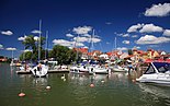
The town was a growing tourist center before the war, and is now one of the largest tourist sights in Masuria. The ice sailing in winter is an especially popular attraction.
Since 2005, the Rally of Poland has been based in Mikołajki.
Gallery
-

-

-
-
 Skyline of Mikołajki
 -
![Lutheran Holy Trinity church[2]](//upload.wikimedia.org/wikipedia/commons/thumb/1/1a/POL_Mikolajki_02.jpg/155px-POL_Mikolajki_02.jpg)
-
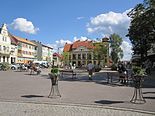 Freedom Square (Plac Wolności)


.jpg)
![Lutheran Holy Trinity church[2]](/wiki/File:POL_Mikolajki_02.jpg)
.jpg)
International relations
Twin towns — Sister cities
Mikołajki is twinned with:
References
- ^ a b Czopek-Kopciuch, Barbara. "Geographical Names Deriving from Saints' Names (Patrocinia) in Poland" (PDF). p. 231.
- ^ a b Bednarz, Klaus (1996). Fernes nahes Land (in German). Hoffmann und Campe. p. 30. ISBN 3-455-11059-2.
- ^ a b c Słownik geograficzny Królestwa Polskiego i innych krajów słowiańskich, Tom VI, Warszawa, 1885, p. 400 (in Polish)
- ^ Mrągowo. Z dziejów miasta i powiatu. Andrzej Wakar Pojezierze, 1975, page 101
- ^ Andreas Kossert: "Wilhelminische Ostmarkenpolitik als infrastrukturelle Durchdringung? Masuren und der deutsch-polnische Antagonismus" in: Comparativ vol. 2 (2005), page 56 Template:De icon
- ^ Marzian, Herbert; Kenez, Csaba (1970). Selbstbestimmung für Ostdeutschland – Eine Dokumentation zum 50 Jahrestag der ost- und westpreussischen Volksabstimmung am 11. Juli 1920 (in German). p. 114.
External links
- Mikołajki, at Phorum website
- Official website (in Polish)
| International | |
|---|---|
| National | |
| Geographic | |
This Mrągowo County location article is a stub. You can help Wikipedia by expanding it. |