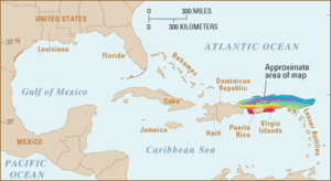
Milwaukee Deep


Milwaukee Deep, also known as The Milwaukee Depth, (19°35′N 66°30′W / 19.583°N 66.500°W) is the deepest part of the Atlantic Ocean and is part of the Puerto Rico Trench.[1] It has a maximum depth of at least 27,493 feet (8,380 m). It is just 76.0 miles (122.3 km) north of the coast of Puerto Rico at Punto Palmas Altas in Manatí.[2][3]
This ocean floor feature is named for the USS Milwaukee (CL-5), a U.S. Navy Omaha class cruiser, which discovered the Milwaukee Deep on February 14, 1939 with a reading of 28,680 feet (8,740 m).[4][5]
On August 19, 1952, the U.S. Fish and Wildlife vessel Theodore N. Gill obtained a reading of 28,560 feet (8,710 m) at (19°36′N 68°19′W / 19.600°N 68.317°W), virtually identical with the Milwaukee's reading.
The United States Citizen Victor Vescovo dived to the bottom of the Puerto Rico Trench on 19th of December 2018. He reached a depth of 8376m with the deep diving submersible Limiting Factor.[6]
The existence of deep water to the Atlantic Ocean side of the Caribbean has been known for more than a century. One of the area's earliest soundings was obtained June 12, 1852 by Lt. S. P. Lee, U.S. Navy brig Dolphin, with a reading of 22,950 feet (7,000 m) at (26°32′N 60°06′W / 26.533°N 60.100°W).[7]
See also
References
- ^ Vaughn; et al. (1940). "Chart I. - Major Ocean Basins with Depths Exceeding 4000 meters (I-XLV)" (PDF). earthguide.ucsd.edu. Retrieved 2014-08-25.
{{cite web}}: Explicit use of et al. in:|author=(help) - ^ "Milwaukee Depth". Encyclopædia Britannica. 2009. Encyclopædia Britannica Online. 12 October 2009 <http://www.britannica.com/EBchecked/topic/383165/Milwaukee-Depth>.
- ^ Bulent Kastarlak (1958). "Low Cost Housing Development with Aided Self-Help Method in Bayamon, Commonwealth of Puerto Rico" (PDF). dspace.mit.edu. Archived from the original (PDF) on 2014-08-26. Retrieved 2014-08-25.
{{cite web}}: Unknown parameter|deadurl=ignored (|url-status=suggested) (help) - ^ Vaughn; et al. (1940). "Chapter II: The Earth and its Ocean Basins" (PDF). earthguide.ucsd.edu. Retrieved 2014-08-25.
{{cite web}}: Explicit use of et al. in:|author=(help) - ^ Silverstone, Paul (2008). The Navy of World War II: 1922-1947.
- ^ "A $48 million submarine just took a record-breaking dive into the deepest corner of the Atlantic Ocean — 27,840 feet down". Business Insider. Retrieved 2018-12-21.
- ^ The Deepest Sounding in the North Atlantic, J. Lyman, Proceedings of the Royal Society of London. Series A, Mathematical and Physical Sciences, Vol. 222, No. 1150, A Discussion on the Floor of the Atlantic Ocean (March 18, 1954), pp. 334–336. Published by: The Royal Society. <https://www.jstor.org/stable/99222>

