Saint George (Staten Island Railway station): Difference between revisions
m override legend |
No edit summary |
||
| Line 11: | Line 11: | ||
| image_caption = From street |
| image_caption = From street |
||
| platforms = 6 [[island platform]]s (5 in revenue service) |
| platforms = 6 [[island platform]]s (5 in revenue service) |
||
| tracks = 10 |
| tracks = 12 (10 in revenue service) |
||
| structure = |
| structure = |
||
| address = Bay Street & Richmond Terrace<br/>Staten Island, NY 10301 |
| address = Bay Street & Richmond Terrace<br/>Staten Island, NY 10301 |
||
| Line 21: | Line 21: | ||
| close_date = |
| close_date = |
||
| next_north = (terminus) |
| next_north = (terminus) |
||
| next_south = [[Tompkinsville (Staten Island Railway station)|Tompkinsville]] (local via |
| next_south = [[Tompkinsville (Staten Island Railway station)|Tompkinsville]] (local via Bay Street Line)<br/>[[New Dorp (Staten Island Railway station)|New Dorp]] (AM rush hour express via Bay Street Line and Hylan Line)<br />[[Great Kills (Staten Island Railway station)|Great Kills]] (PM rush hour express via Bay Street Line and Hylan Line) <br/>[[Richmond County Bank Ballpark (Staten Island Railway station)|Richmond County Bank Ballpark]] (North Shore Line; game days only) |
||
| next_north_acc = none |
| next_north_acc = none |
||
| next_south_acc = [[Dongan Hills (Staten Island Railway station)|Dongan Hills]] |
| next_south_acc = [[Dongan Hills (Staten Island Railway station)|Dongan Hills]] |
||
Revision as of 20:57, 17 December 2009
This article needs additional citations for verification. (February 2009) |
Saint George | |||
|---|---|---|---|
 From street | |||
| Station statistics | |||
| Address | Bay Street & Richmond Terrace Staten Island, NY 10301 | ||
| Borough | Staten Island | ||
| Locale | St. George | ||
| Coordinates | 40°38′36″N 74°4′27″W / 40.64333°N 74.07417°W | ||
| Division | [1] | ||
| Services | SIR Main Line service | ||
| Transit | Staten Island Ferry | ||
| Platforms | 6 island platforms (5 in revenue service) | ||
| Tracks | 12 (10 in revenue service) | ||
| Other information | |||
| Opened | July 31, 1884[2] | ||
| Accessible | |||
| Traffic | |||
| 2023 | [3] | ||
| Rank | out of 423[3] | ||
| Station succession | |||
| Next north | (terminus) | ||
| Next south | Tompkinsville (local via Bay Street Line) New Dorp (AM rush hour express via Bay Street Line and Hylan Line) Great Kills (PM rush hour express via Bay Street Line and Hylan Line) Richmond County Bank Ballpark (North Shore Line; game days only) | ||
| |||
| |||
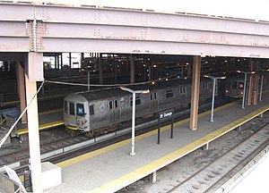
Saint George is a Staten Island Railway station in the neighborhood of Saint George, Staten Island, New York. Located at the Staten Island Ferry Terminal Building on the lower level, it is the northern terminus on the main line. It is also one of two stations that requires the US$2.25 fare on entry and exit.
This station is handicapped accessible and it is compliant with the Americans with Disabilities Act.[4][5]
This station is open cut with a four-lane bus terminal and parking lot above it. The station has five active platforms and ten tracks, numbered 1 through 10 from east to west. There is also a sixth platform to the west that is a passageway to the North Municipal Parking Field on Richmond Terrace, and towards Richmond County Bank Ballpark, one of two access points to this station. The track ballast is present through this construction zone. The mezzanine area has separate fare control areas, east side for entering passengers, and west side for exiting. Station booths and MetroCard vending machines are located on both sides. Just before each platform bay are the old destination indicators to the left and right of each platform entrance, corresponding to each departing track. There are green bulbs above these displays that indicate where the next train will be leaving from. This station originally opened with nothing overhead, no bus bays, no ramps. It was the site of a 1949 fire that nearly destroyed the terminal.
Connections
- Staten Island Ferry to South Ferry, Manhattan
- Bus: S40, S42, S44, S46, S48, S51, S52, S61, S62, S66, S67, S74, S76, S78, S81, S84, S86, S90, S91, S92, S94, S96, and S98
External links
References
- ^ "Glossary". Second Avenue Subway Supplemental Draft Environmental Impact Statement (SDEIS) (PDF). Vol. 1. Metropolitan Transportation Authority. March 4, 2003. pp. 1–2. Archived from the original (PDF) on February 26, 2021. Retrieved January 1, 2021.
- ^ Irvin Leigh and Paul Matus (December 23, 2001). "SIRT The Essential History". p. 6. Retrieved 2009-03-03.
- ^ a b "Annual Subway Ridership (2018–2023)". Metropolitan Transportation Authority. 2023. Retrieved April 20, 2024.
- ^ "North Shore line".
- ^ "MTA NYC Transit - Staten Island Railway Strip map (including bus transfers and parking)". Retrieved 2009-02-26.


