
Tünel: Difference between revisions
No edit summary |
|||
| Line 32: | Line 32: | ||
==History== |
==History== |
||
[[File:Gavand-Tunel-Fig11.jpg|thumb|right|200px|Profile of the tunnel, from ''Chemin de fer métropolitain de Constantinople, ou Chemin de fer souterrain de Galata à Péra, dit tunnel de Constantinople. Projet d'une nouvelle ville et d'un nouveau port de commerce à Constantinople'' by Eugène-Henri Gavand (1876).]] |
[[File:Gavand-Tunel-Fig11.jpg|thumb|right|200px|Profile of the tunnel, from ''Chemin de fer métropolitain de Constantinople, ou Chemin de fer souterrain de Galata à Péra, dit tunnel de Constantinople. Projet d'une nouvelle ville et d'un nouveau port de commerce à Constantinople'' by Eugène-Henri Gavand (1876).]] |
||
In the second half of the 19th century the neighborhoods of ''Pera'' (modern day Beyoğlu) and ''Galata'' (modern day [[Karaköy]]) had become the financial and commercial heart of [[Istanbul|Constantinople]] (modern day Istanbul) and the [[Ottoman Empire]]. Many Ottoman and foreign companies, mostly banks and insurance companies, set up their headquarters in these two neighborhoods. Separated by a large hill, Foreign embassies, hotels and commercial markets in Pera were located on the top while the stock exchange, banks and ports in Galata were at the bottom. Travelling between these two districts were tough as grades were as steep as 24%. The main street between these two areas, Yüksek Kaldırım Avenue, saw an average of 40,000 people commuting up and down the hill daily.<ref name="Çelik">''The remaking of Istanbul: portrait of an Ottoman city in the nineteenth century'', pp. 96-98. Çelik, Zeynep. University of California Press, 1993. ISBN 978-0-520-08239-7</ref> |
|||
The Tünel was originally conceived by the [[France|French]] engineer Eugène-Henri Gavand in 1867.<ref name=Tunel/> Its purpose was to provide an easy ride between the neighbourhoods of [[Pera]] (Beyoğlu) and [[Galata]] (Karaköy), both of which were in the relatively newer part of Istanbul, on the northern shore of the [[Golden Horn]]. Many people worked in Galata close to sea level, living uphill in Pera, about {{convert|60|m|0|abbr=off|sp=uk}} higher. The only direct street connecting the two, Yüksek Kaldırım, is steep and narrow; at the time of the construction of the Tünel, crowded with 40,000 pedestrians a day. Gavand conceived of the Tünel as "a kind of elevator ascending and descending" that would greatly ease the journey.<ref name="Çelik"/> |
|||
In 1867 a [[France|French]] engineer, Eugène-Henri Gavand, came to Constantinople for touristic purposes<ref name="Çelik"/>. During his visit he was taken back at the amount of people travelling on Yüksek Kaldırım Avenue. Gavand thought of a method to connect these two areas and came up with building a [[funicular railway]] that would ascend and descend the hill. Gavand went back to France shortly after to prepare his project. He returned to Constantinople in February 1868 to present his project to the [[Sublime Port]]. The railway would run from beginning of Yüksek Kaldırım Avenue in Pera to Yenicami street and close to the [[Galata Bridge]] in Galata. On 10 June 1869 [[Sultan of the Ottoman Empire|Sultan]] [[Abdülaziz]] granted Gavand with a concession to build the railway. Gavand worked with shareholders in France to start up a company to build the railway, but due to the [[Franco-Prussian War|Prussian invasion of France]] the formation of a French-based company became impossible. |
|||
| ⚫ | |||
| ⚫ | During the war, Gavand went to the [[United Kingdom]] to set the company up there. He formed the '''Metropolitan Railway of Constantinople''' to construct the line with the starting date being on 1 September 1871. Construction began on July 30, 1871 but was delayed significantly by conflicts between landowners and the company.<ref name="Çelik"/> The tunnel was not completed until December 1874 <ref name=Tunel/> and was finally opened for service on January 17, 1875.<ref name=Tunel/> |
||
The Metropolitan Railway company gained a fresh 75-year concession in 1904 but the Tünel was nationalised in 1923 when the Turkish Republic was proclaimed.<ref name="Çelik"/> In 1939 it was absorbed into the new [[IETT]] (İstanbul Elektrik Tramvay ve Tünel) transportation organization.<ref name=Tunel/> It was modernised and electrified in 1971.<ref name="funimag26-03"/> Today, the short line is no longer as vital for Istanbul's inner city traffic as it used to be back in the 19th century, but it is still a part of the municipal transport network and integrated tickets are valid. |
The Metropolitan Railway company gained a fresh 75-year concession in 1904 but the Tünel was nationalised in 1923 when the Turkish Republic was proclaimed.<ref name="Çelik"/> In 1939 it was absorbed into the new [[IETT]] (İstanbul Elektrik Tramvay ve Tünel) transportation organization.<ref name=Tunel/> It was modernised and electrified in 1971.<ref name="funimag26-03"/> Today, the short line is no longer as vital for Istanbul's inner city traffic as it used to be back in the 19th century, but it is still a part of the municipal transport network and integrated tickets are valid. |
||
Revision as of 22:44, 2 January 2015
| Tünel | |||
|---|---|---|---|
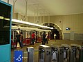
 Karaköy station. | |||
| Overview | |||
| Owner | Istanbul Metropolitan Municipality | ||
| Locale | Istanbul | ||
| Transit type | Funicular | ||
| Number of stations | 2 | ||
| Website | Tünel/Tunnel | ||
| Operation | |||
| Began operation | 17 January 1875 | ||
| Operator(s) | İETT | ||
| Number of vehicles | 2 | ||
| Technical | |||
| System length | 573 km (356 mi) | ||
| Track gauge | 1,435 mm (4 ft 8+1⁄2 in) (standard gauge) | ||
| |||
The Tünel (English: Tunnel ) is a short underground railway line in Istanbul, Turkey. It is an underground funicular with two stations, connecting the quarters of Karaköy and Beyoğlu. Located at the northern shore of the Golden Horn, the underground railway tunnel goes uphill from close to sea level and is about 573 metres long.[1] Inaugurated on January 17, 1875,[1] the Tünel is the second-oldest subterranean urban rail line in the world, after the London Underground (1863), and the first subterranean urban rail line in continental Europe.
History

In the second half of the 19th century the neighborhoods of Pera (modern day Beyoğlu) and Galata (modern day Karaköy) had become the financial and commercial heart of Constantinople (modern day Istanbul) and the Ottoman Empire. Many Ottoman and foreign companies, mostly banks and insurance companies, set up their headquarters in these two neighborhoods. Separated by a large hill, Foreign embassies, hotels and commercial markets in Pera were located on the top while the stock exchange, banks and ports in Galata were at the bottom. Travelling between these two districts were tough as grades were as steep as 24%. The main street between these two areas, Yüksek Kaldırım Avenue, saw an average of 40,000 people commuting up and down the hill daily.[2]
In 1867 a French engineer, Eugène-Henri Gavand, came to Constantinople for touristic purposes[2]. During his visit he was taken back at the amount of people travelling on Yüksek Kaldırım Avenue. Gavand thought of a method to connect these two areas and came up with building a funicular railway that would ascend and descend the hill. Gavand went back to France shortly after to prepare his project. He returned to Constantinople in February 1868 to present his project to the Sublime Port. The railway would run from beginning of Yüksek Kaldırım Avenue in Pera to Yenicami street and close to the Galata Bridge in Galata. On 10 June 1869 Sultan Abdülaziz granted Gavand with a concession to build the railway. Gavand worked with shareholders in France to start up a company to build the railway, but due to the Prussian invasion of France the formation of a French-based company became impossible.
During the war, Gavand went to the United Kingdom to set the company up there. He formed the Metropolitan Railway of Constantinople to construct the line with the starting date being on 1 September 1871. Construction began on July 30, 1871 but was delayed significantly by conflicts between landowners and the company.[2] The tunnel was not completed until December 1874 [1] and was finally opened for service on January 17, 1875.[1]
The Metropolitan Railway company gained a fresh 75-year concession in 1904 but the Tünel was nationalised in 1923 when the Turkish Republic was proclaimed.[2] In 1939 it was absorbed into the new IETT (İstanbul Elektrik Tramvay ve Tünel) transportation organization.[1] It was modernised and electrified in 1971.[3] Today, the short line is no longer as vital for Istanbul's inner city traffic as it used to be back in the 19th century, but it is still a part of the municipal transport network and integrated tickets are valid.
Description
The Tünel consists of a single brick-lined tunnel measuring 554.8 metres (1,820 ft) long, 6.7 metres (22 ft) wide and 4.9 metres (16 ft) high. It has one station at either end. The lower station is named Karaköy (located on the eastern end of Tersane Avenue at 41°01′22″N 28°58′30″E / 41.0229°N 28.9749°E), and the upper station Tünel Meydanı - Tünel Square (located on the southern end of Istiklal Avenue at 41°01′40″N 28°58′19″E / 41.0278°N 28.9719°E). The upper station stands 61.55 metres (201.9 ft) higher than the lower one. The slope of the tunnel varies along its length from 2 percent to 15 percent. It was originally built with two parallel lines,[2] but now has a single track with a short duplex section in the middle, where two trains pass side by side.
Rolling stock
The original rolling stock on the Tünel consisted of two wooden two-car trains. One car was reserved for passengers, with two classes provided, each of which had separate compartments for men and women. The other car was used to transport goods, animals and even horse-drawn carriages.[2] Motive power was provided by steam engines.[4]
The wooden carriages were replaced in 1971 with two electrified steel cars running on pneumatic tires. Their cruising speed is roughly 25 km/h (16 mph). A trip between the two stations takes about 1.5 minutes, with an extra two minutes of waiting between operations to allow passengers to board the train.[3][4]
Gallery
-
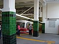
 The Funicular was built in moresque style
 -
 Karaköy station
 -
 Tünel Meydanı (Beyoğlu) station
 -
 Map showing the route of the Tünel


See also
- Istanbul Metro
- Istanbul modern tramways
- Istanbul nostalgic tramways
- List of rapid transit systems
- Public transport in Istanbul
References
- Notes
- ^ a b c d e "Tunnel". IETT. Retrieved 2014-04-25.
- ^ a b c d e f The remaking of Istanbul: portrait of an Ottoman city in the nineteenth century, pp. 96-98. Çelik, Zeynep. University of California Press, 1993. ISBN 978-0-520-08239-7
- ^ a b "The 1971 funicular". Funimag, issue 26. 27 September 2005. Retrieved 19 July 2009.
{{cite web}}: Italic or bold markup not allowed in:|work=(help) - ^ a b "The first funicular – The Tünel". Funimag, issue 26. 27 September 2005. Retrieved 19 July 2009.
{{cite web}}: Italic or bold markup not allowed in:|work=(help)
External links
| |||||
| |
| ||||
| |||||
| |||||
| Operators | |||||
Lines in italic are under construction with planned opening year in parentheses. | |||||