
Îles d'Hyères
You can help expand this article with text translated from the corresponding article in French. (September 2013) Click [show] for important translation instructions.
|
The Îles d'Hyères (pronounced [il djɛːʁ]; or Îles d'Or, [il dɔːʁ]) are a group of four Mediterranean islands off Hyères in the Var département of south-east France. With a combined area of 29 square kilometers, they comprise:
- Porquerolles – 1,254 hectares, an extension of the Giens peninsula
- Port-Cros – 650 hectares, the most mountainous, a national park, noted for rare flora and as a bird refuge
- Île du Bagaud – 45 hectares, part of the same national park, and without permitted access
- Île du Levant – 900 hectares, mostly for military use, partly a long-established nudist colony centered on the privately owned village of Héliopolis
-
 Porquerolles
 -
 Porquerolles
 -
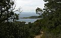 Port-Cros
 -
 Île du Levant


See also
References
Wikivoyage has a travel guide for Îles d'Hyères.
43°00′36″N 6°24′16″E / 43.01°N 6.4045°E
This Var geographical article is a stub. You can help Wikipedia by expanding it. |